


一种基于北斗三号系统的GNSS-R海面干涉测高技术
doi: 10.11728/cjss2022.03.210315029 cstr: 32142.14.cjss2022.03.210315029
A New GNSS-R Interferometric Ocean Altimetry Using Beidou-3 Signal
-
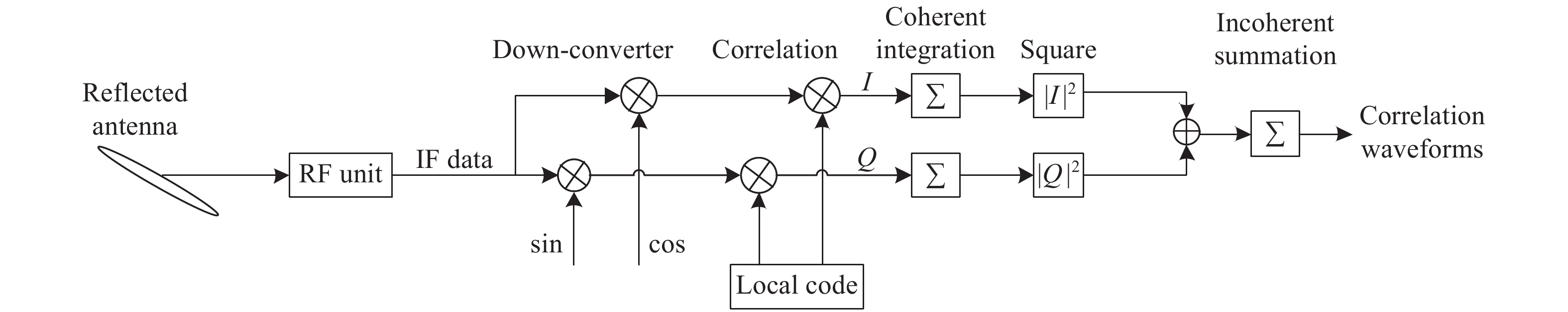
摘要: GNSS-R干涉测高技术可用于中尺度海面高度观测,具有空间分辨率高、测量精度高等优势。与传统的GNSS-R本地码测高技术相比,GNSS-R干涉测高技术可以有效提升高度测量精度。虽然GNSS-R干涉测高技术已有一些研究,但是基于北斗三号的干涉测高应用还很少。本文根据GNSS-R干涉测高技术优势,针对北斗三号系统在干涉测高技术上的应用,研发了支持北斗三号的GNSS-R干涉测高接收机并描述了整体架构及实现。利用所研发的接收机进行水面干涉测高试验,首次获取了北斗三号B1和B2干涉测高波形,与传统GPS L1和北斗B1本地码测高波形进行对比。对两种方法计算出的水面高度进行对比,结果显示北斗三号干涉测高精度明显优于GPS L1和北斗B1传统本地码测高精度。Abstract: GNSS-R interferometric altimetry can be used for meso-scale sea level observation with the advantages of high spatial resolution and high measurement accuracy. Compared with the traditional GNSS-R which uses local code tracking for altimetry, GNSS-R interferometric could effectively improve the altimetry accuracy. Although a lot of researches had been carried out in GNSS-R interferometric altimetry around the world, there are few researches in the application of interferometric altimetry using Beidou-3 signal. This article introduces the basic theory of GNSS-R interferometric altimetry technology and its advantages. Aiming at the application of Beidou-3 signal in interferometric altimetry, a GNSS interferometric altimetry instrument had been developed. The overall architecture and implementation of this new instrument is introduced in this paper. An open-field GNSS-R water surface altimetry experiments was conducted using this instrument. In the experiment, the interferometric waveforms generated from Beidou-3 B1 and B2 signal were obtained for the first time, and were compared with the traditional GPS L1 and Beidou-2 B1 local code tracking waveforms. Finally, the inversion results of the water surface height calculated by the two approaches are compared. The comparison results show that the precision of Beidou-3 system’s interferometric measurement is significantly better than that of GPS L1 and Beidou-2 B1 traditional local code altimetry.
-
Key words:
- GNSS-R /
- Beidou-3 /
- Interferometric altimetry /
- Local code altimetry
-

图 3 GPS L1频段干涉测高与GPS L1本地码测高波形
Figure 3. GPS L1 C/A and L1 interferometric ACF results

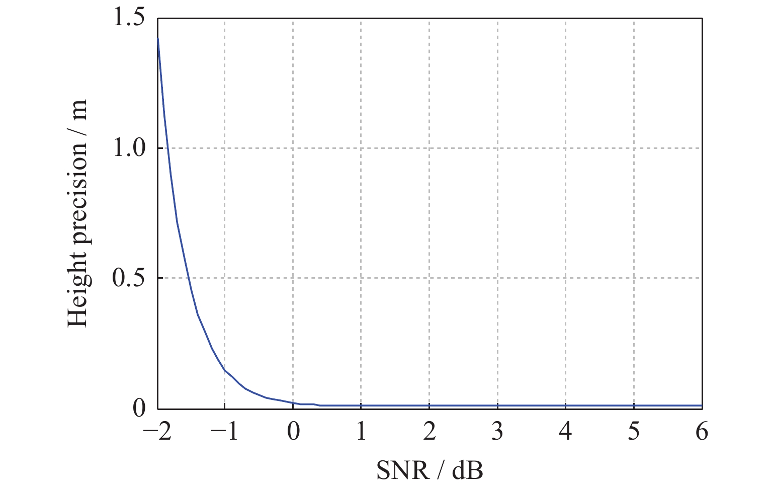
图 4 不同波形因子K和信号载噪比CNR与测高精度的关系
Figure 4. Relationships between K, CNR and the height precision

图 5 非相干累加次数与测高精度的关系
Figure 5. Relationship between incoherent integration count and the height precision

图 7 B1频段信号带宽与测高精度的关系
Figure 7. Relationship between the B1 bandwidth and height precision

图 9 BD (a),GPS (b)和GAL (c)实测干涉测高波形
Figure 9. Received BD (a), GPS (b) and GAL (c) interferometric tracking waveforms

图 10 BD (a),GPS (b)和GAL (c)实测本地码测高波形
Figure 10. Received BD (a), GPS (b) and GAL (c) local code tracking waveforms

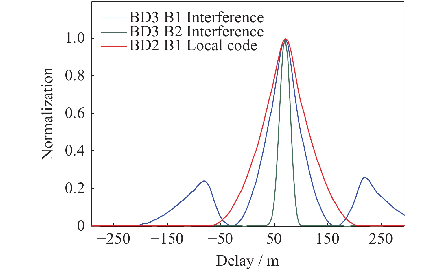
图 11 北斗三号干涉测高与本地码测高波形的对比
Figure 11. Comparison between BD3 interference and BD2 B1 local tracking results
表 1 本地码测高技术与干涉测高技术可利用的GNSS信号对比
Table 1. Available GNSS signals using interference and local code tracking technology
导航
系统频段 码型及带宽/MHz 本地测高技术
可使用码型本地测高技术可
利用带宽/MHz干涉测高技术
可使用码型干涉测高技术可
利用带宽/MHzGPS L1 L1C/A+L1P(授权)+
M(授权)
(32.736)L1C/A 2.046 L1C/A+L1P+M 32.736 L2 L2C+L2P(授权)
(20.46)L2C 2.046 L2C+L2P 20.46 L5 L5I+L5Q
(20.46)L5I+L5Q 20.46 L5I+L5Q 20.46 BDS B1I B1I(4.092) B1I 4.092 B1I 4.092 B1C B1C(32.736) B1C 32.736 B1C 32.736 B2 B2A+B2B(51.15) B2A或B2B 20.46 B2A+B2B 51.15 B3I B3I(20.46) B3I 20.46 B3I 20.46 GAL E1 E1B+E1C(32) E1B或E1C 4.092 E1B+E1C 32 E5 E5a+E5b(51.15) E5a或E5b 20.46 E5a+E5b 51.15 E6 E6B+E6C(40.92) 授权 – E6B+E6C 40.92  下载: 导出CSV
表 2 水面高度计算结果(单位m)
Table 2. Results of the water surface height (unit m)
跟踪类型 卫星号 时间段(UT) 高度标准差 GPS L1本地码 G17 2019-09-27 01:14-1:44 0.78 北斗B1
本地码B13 2019-09-27 08:18-8:48 0.90 北斗三号B1
干涉B19 2019-09-27 09:10-9:40 0.14 北斗三号B2干涉 B22 2019-09-27 11:29-11:59 0.12
下载: 导出CSV
-
[1] 符养, 周兆明. GNSS-R海洋遥感方法研究[J]. 武汉大学学报/信息科学版, 2006, 31(2): 128-131FU Yang, ZHOU Zhaoming. Investigation of ocean remote sensing by using GNSS-R signal[J]. Geomatics and Information Science of Wuhan University, 2006, 31(2): 128-131 [2] ZAVOROTNY V U, VORONOVICH A G. Scattering of GPS signals from the ocean with wind remote sensing application[J]. IEEE Transactions on Geoscience and Remote Sensing, 2000, 38(2): 951-964 doi: 10.1109/36.841977 [3] 骆黎明, 白伟华, 孙越强, 等. 基于树模型机器学习方法的GNSS-R海面风速反演[J]. 空间科学学报, 2020, 40(4): 595-601 doi: 10.11728/cjss2020.04.595LUO Liming, BAI Weihua, SUN Yueqiang, et al. GNSS-R sea surface wind speed inversion based on tree model machine learning method[J]. Chinese Journal of Space Science, 2020, 40(4): 595-601 doi: 10.11728/cjss2020.04.595 [4] CAMPS A, PARK H, PABLOS M, et al. Sensitivity of GNSS-R spaceborne observations to soil moisture and vegetation[J]. IEEE Journal of Selected Topics in Applied Earth Observations and Remote Sensing, 2016, 9(10): 4730-4742 doi: 10.1109/JSTARS.2016.2588467 [5] CHEW C, SHAH R, ZUFFADA C, et al. Demonstrating soil moisture remote sensing with observations from the UK TechDemoSat-1 satellite mission[J]. Geophysical Research Letters, 2016, 43(7): 3317-3324 doi: 10.1002/2016GL068189 [6] YAN Q Y, HUANG W M. Sea ice thickness measurement using spaceborne GNSS-R: first results with TechDemoSat-1 data[J]. IEEE Journal of Selected Topics in Applied Earth Observations and Remote Sensing, 2020, 13: 577-587 doi: 10.1109/JSTARS.2020.2966880 [7] MARTÍN-NEIRA M. A passive reflectometry and interferometry system (PARIS): application to ocean altimetry[J]. ESA Journal, 1993, 17: 331-355 [8] MARTÍN-NEIRA M, D’ADDIO S, BUCK C, et al. The PARIS ocean altimeter in-orbit demonstrator[J]. IEEE Transactions on Geoscience and Remote Sensing, 2011, 49(6): 2209-2237 doi: 10.1109/TGRS.2010.2092431 [9] CAMPS A, PARK H, DOMÈNECH E V I, et al. Optimization and performance analysis of interferometric GNSS-R altimeters: application to the PARIS IoD mission[J]. IEEE Journal of Selected Topics in Applied Earth Observations and Remote Sensing, 2014, 7(5): 1436-1451 doi: 10.1109/JSTARS.2014.2320873 [10] RIBÓ S, ARCO-FERNÁNDEZ J C, NOGUÉS-CORREIG O, et al. The software PARIS interferometric receiver[C]//2016 IEEE International Geoscience and Remote Sensing Symposium (IGARSS). Beijing: IEEE, 2016: 5593-5595 [11] RIUS A, NOGUÉS-CORREIG O, RIBÓ S, et al. Altimetry with GNSS-R interferometry: first proof of concept experiment[J]. GPS Solutions, 2012, 16(2): 231-241 doi: 10.1007/s10291-011-0225-9 [12] WICKERT J, CARDELLACH E, MARTIN-NEIRA M, et al. GEROS-ISS: GNSS REflectometry, radio occultation, and Scatterometry onboard the international space station[J]. IEEE Journal of Selected Topics in Applied Earth Observations and Remote Sensing, 2016, 9(10): 4552-4581 doi: 10.1109/JSTARS.2016.2614428 [13] ALONSO-ARROYO A, QUEROL J, LOPEZ-MARTINEZ C, et al. SNR and standard deviation of cGNSS-R and iGNSS-R scatterometric measurements[J]. Sensors, 2017, 17(1): 183 doi: 10.3390/s17010183 [14] PASCUAL D, CAMPS A, MARTIN F, et al. Precision bounds in GNSS-R ocean altimetry[J]. IEEE Journal of Selected Topics in Applied Earth Observations and Remote Sensing, 2014, 7(5): 1416-1423 doi: 10.1109/JSTARS.2014.2303251 -
-

 下载:
下载:


计量
- 文章访问数: 1178
- HTML全文浏览量: 520
- PDF下载量: 63
-
被引次数:
0(来源:Crossref)
0(来源:其他)

