


基于卫星遥感数据的Noah-MP地表反照率关键参数优化
doi: 10.11728/cjss2023.06.2023-0086 cstr: 32142.14.cjss2023.06.2023-0086
Toward Optimization of Key Parameters in Noah-MP Surface Albedo Using Satellite Remote Sensing Products
-
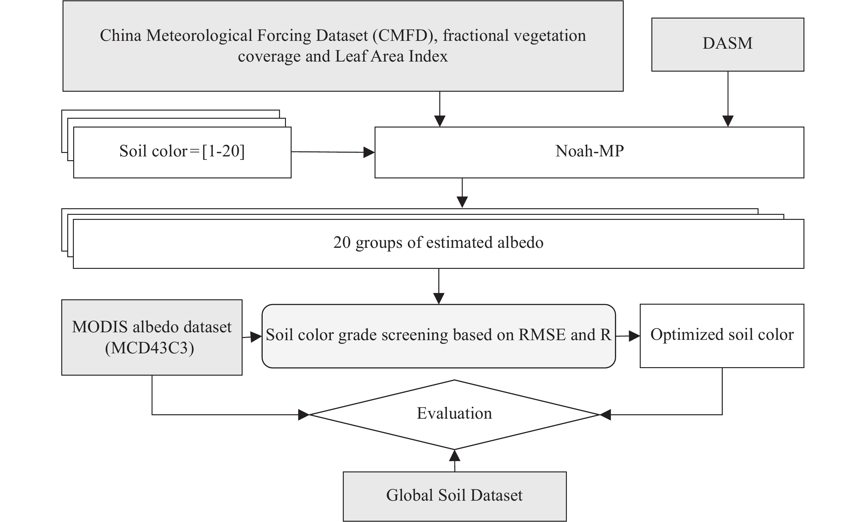
摘要: 地表反照率是影响地–气相互作用的关键因子,而准确描述地表反照率是改进陆面模型水热模拟能力的关键。当前Noah-MP (the Noah land surface model with Multiple Parameterizations) 土壤反照率估算主要依赖于查找表方法,该方法基于土壤颜色获得不同土壤类型的反照率,但在区域尺度上土壤颜色等级尚未得到有效率定,直接影响了区域反照率模拟水平。此外,裸土反照率的计算还高度依赖于土壤水分。针对这一问题,以同化得到的土壤水分数据作为输入,计算得到不同土壤颜色等级对应的反照率时间序列。在此基础上,以MODIS反照率为参照,同时排除高植被覆盖和积雪的影响,逐步筛选得到青藏高原区域0.25°格点尺度下最优的土壤颜色等级。评估结果表明,优化得到的土壤颜色等级空间分布规律符合土壤质地与反照率之间的物理规律,且改进了研究区域70%空间网格内的Noah-MP模型反照率估计。Abstract: Surface albedo is a key factor affecting land-air interactions. The accurate estimate of surface albedo is of great value for improving land model’s capability in hydrothermal simulation. In the Noah-MP (the Noah land surface model with multiple parameterizations) land surface model, estimation of soil albedo mainly relies on a look-up table-based method that characterize the albedo of different soil types with the so-called soil color. However, the soil color has not yet been calibrated at the regional or global scale, which greatly hinders the regional albedo simulation. In addition, the calculation of bare soil albedo is highly sensitive to surface soil moisture. To this end, this study first produces an ensemble of albedo time series with regard to different soil types with data assimilation generated soil moisture as input. Then, the optimal 0.25° soil color for the Tibetan Plateau region were screened by referring MODIS albedo and excluding the impacts from dense vegetation and snow cover. The evaluation results show that the spatial distribution of optimized soil color can reasonably reflect the relationship between soil texture and albedo, and improved Noah-MP albedo estimation in over 70% of the grid cells in the study area.
-
Key words:
- Land surface albedo /
- Noah-MP /
- Soil Color (SC) /
- Parameter optimization
-
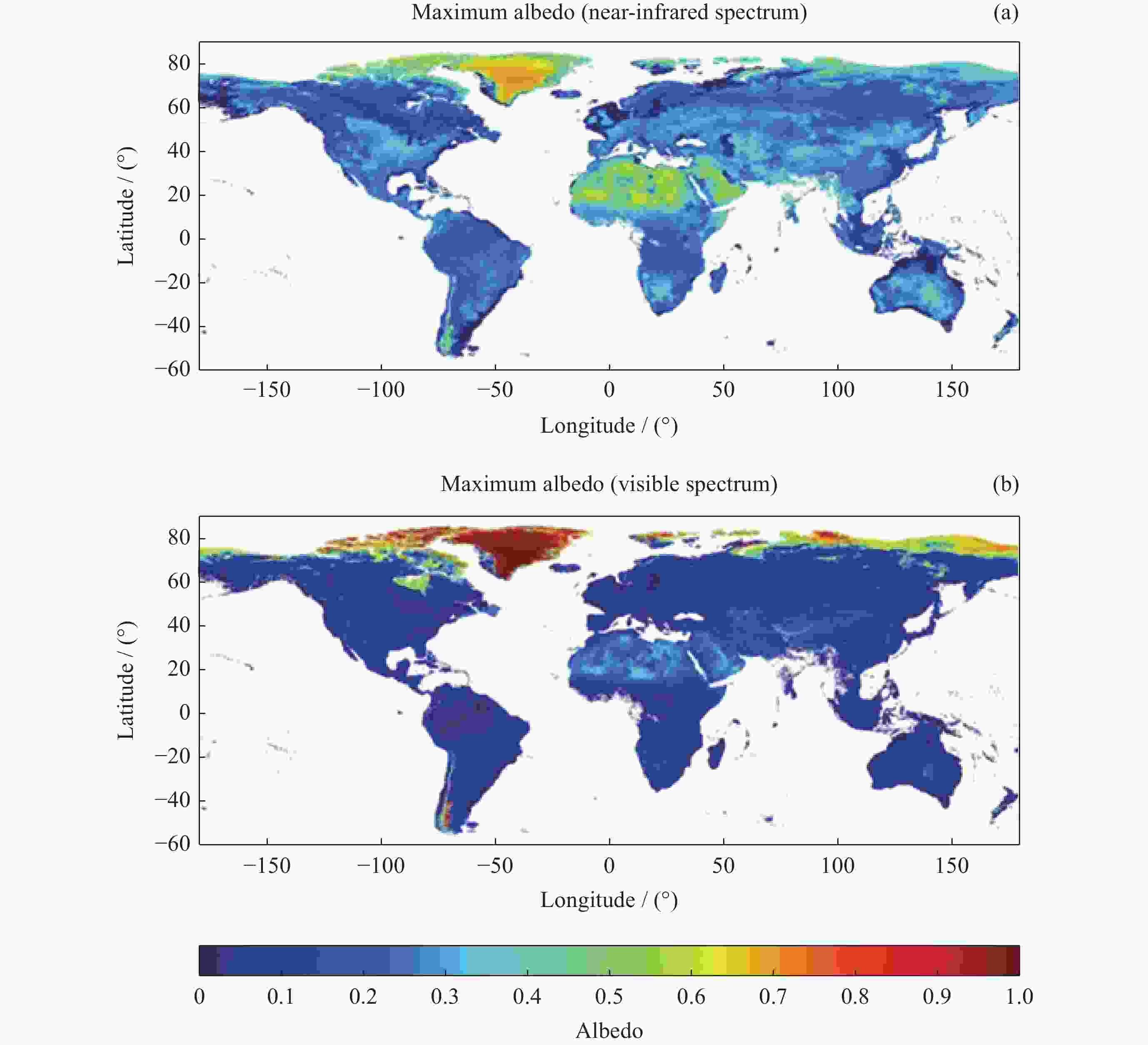
图 1 2016-2020年5-9月全球地表反照率最大值空间分布
Figure 1. Spatial distribution of the maximum global land surface albedo from 2016 to 2020 (Only for May to September)
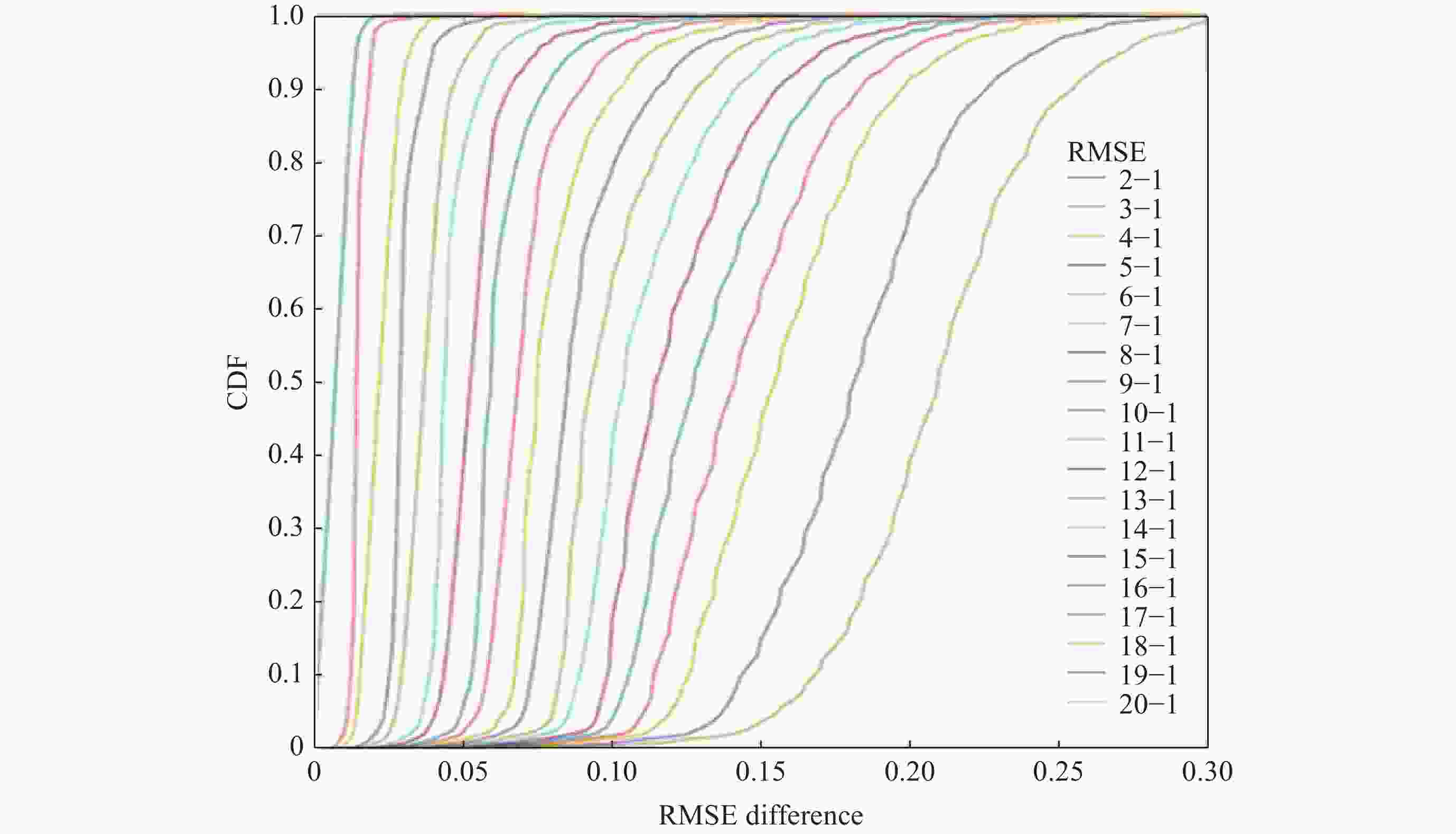
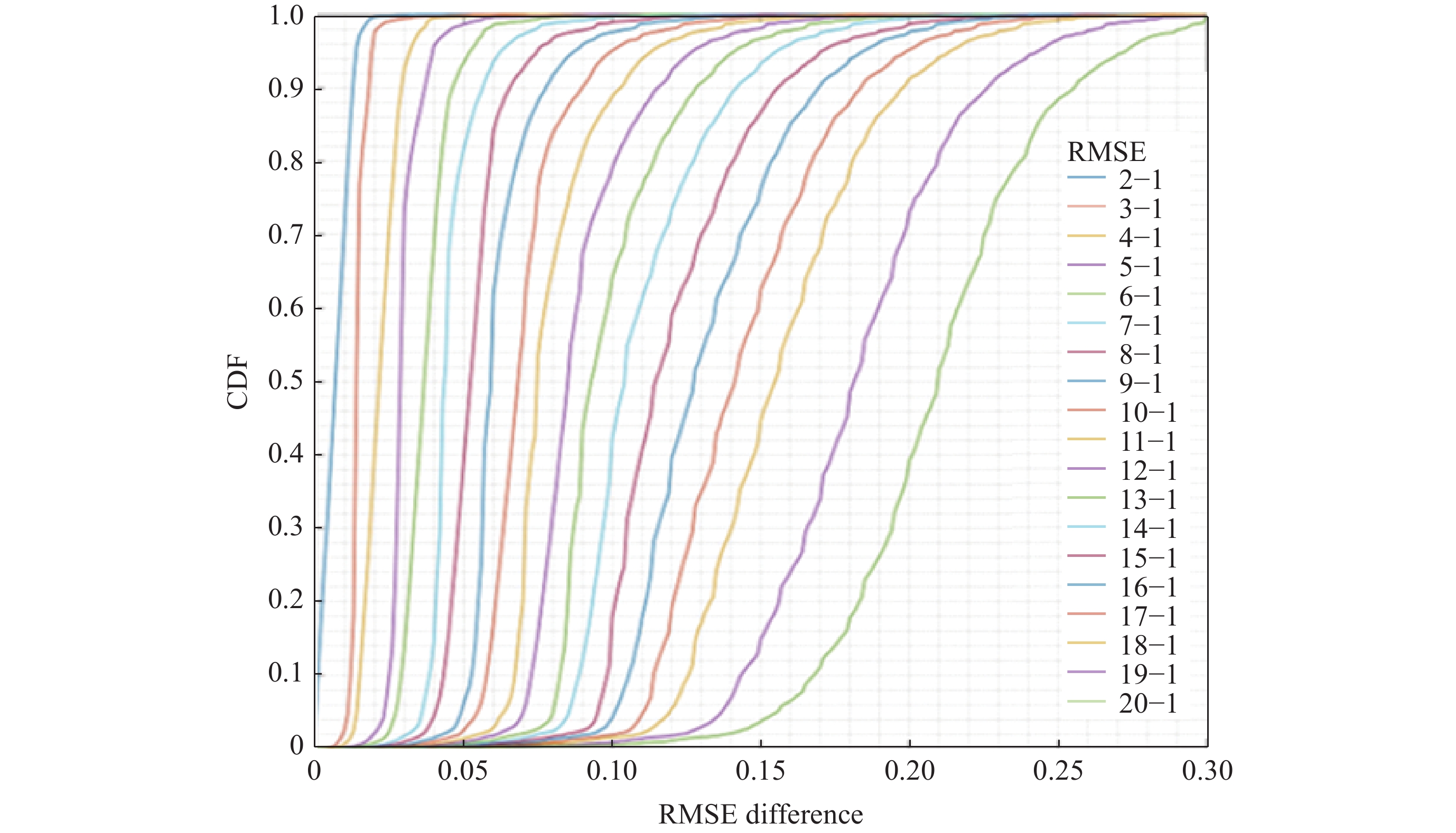
图 3 所有网格单元的排名最高和后19位土壤颜色等级对应的RMSE之间差异的累积分布函数(CDF)
Figure 3. Cumulative Distribution Function (CDF) of statistics differences overall grid-cells in terms of RMSE with regard to different soil colors
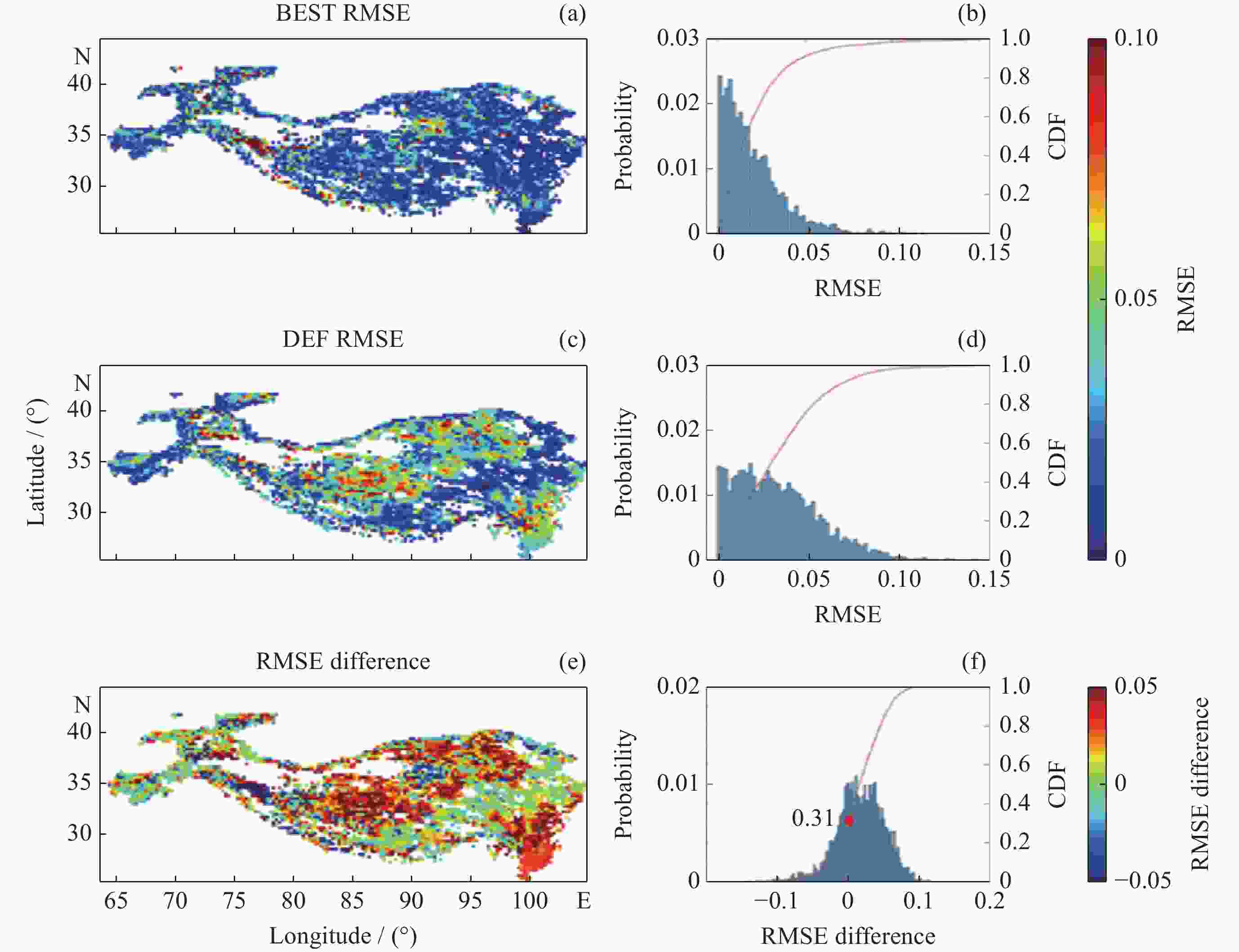
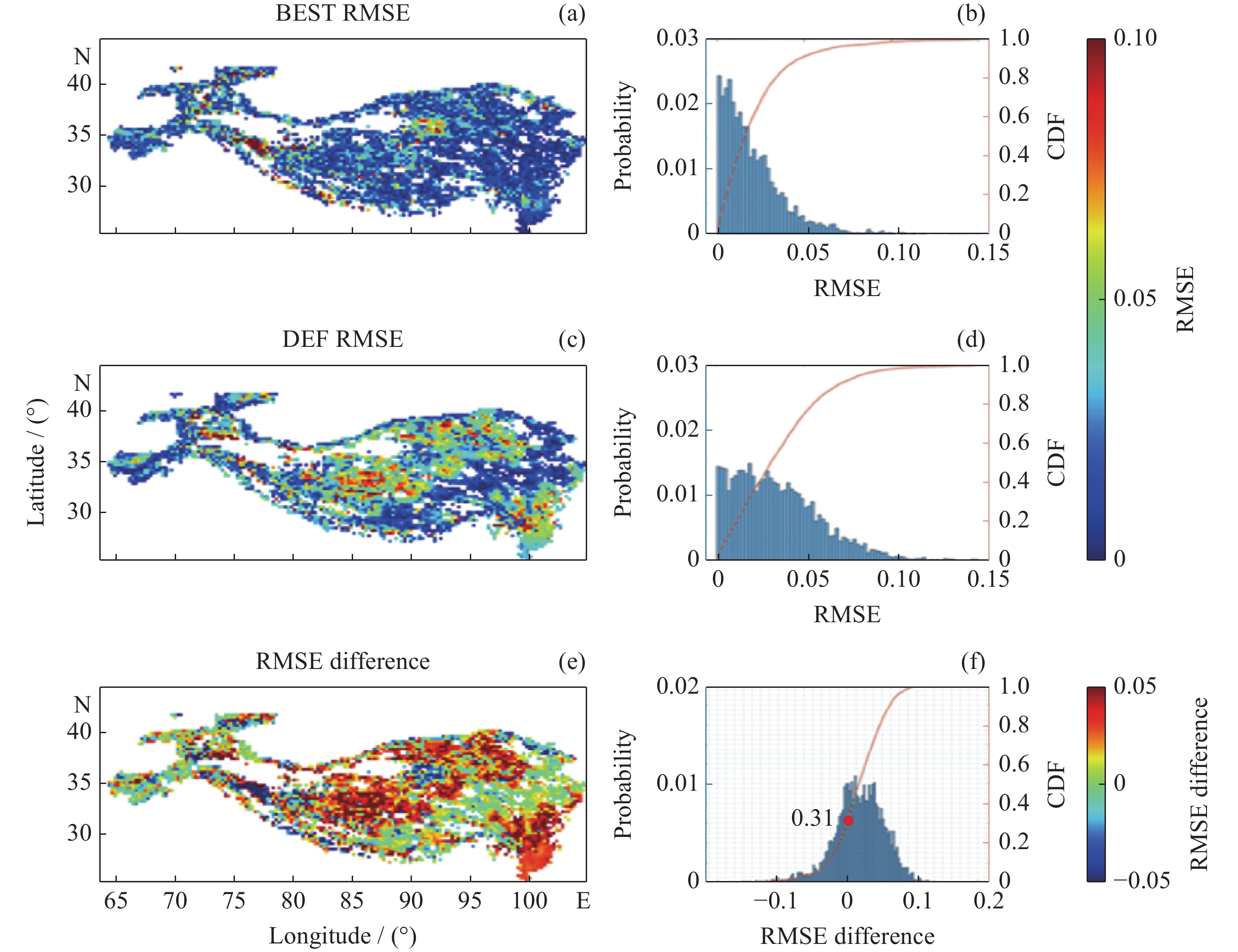
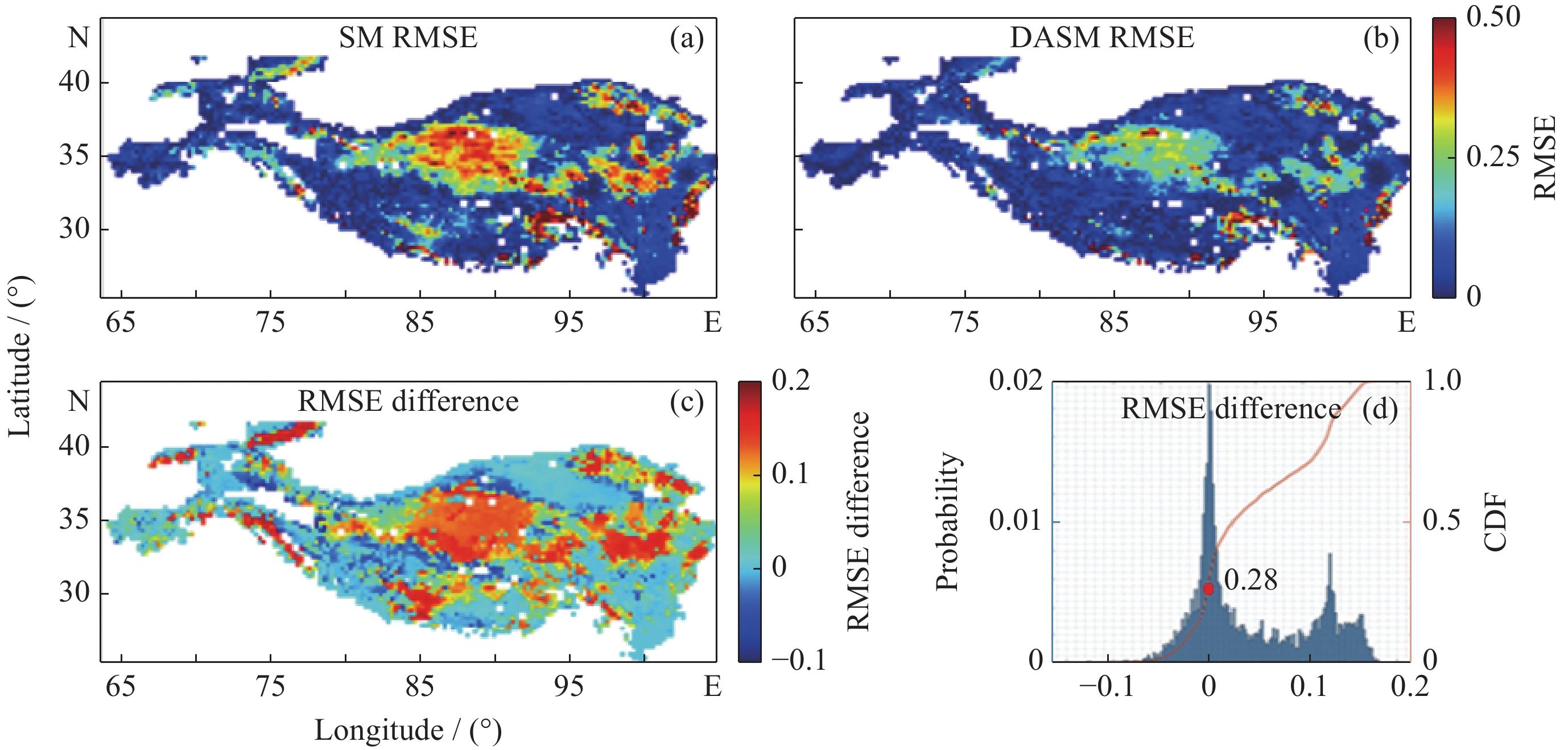
图 5 基于MODIS反照率数据的最优土壤颜色等级评估结果
Figure 5. Evaluation results of optimal soil color based on MODIS albedo data
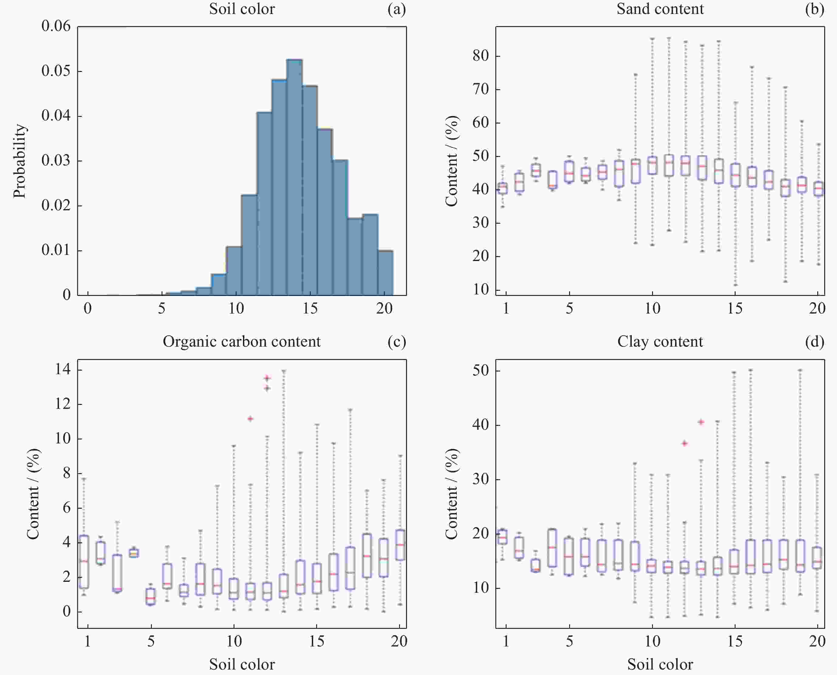
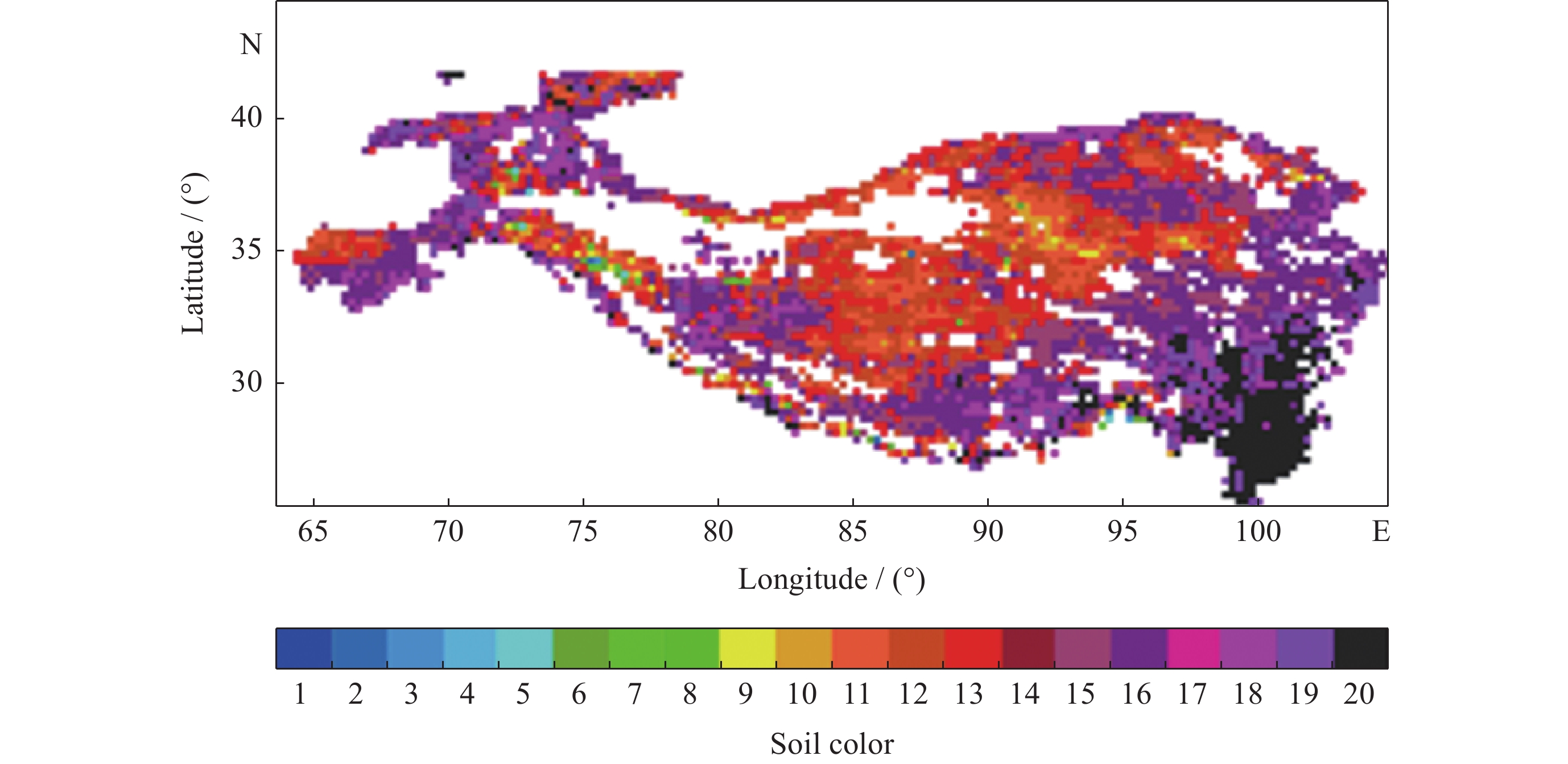
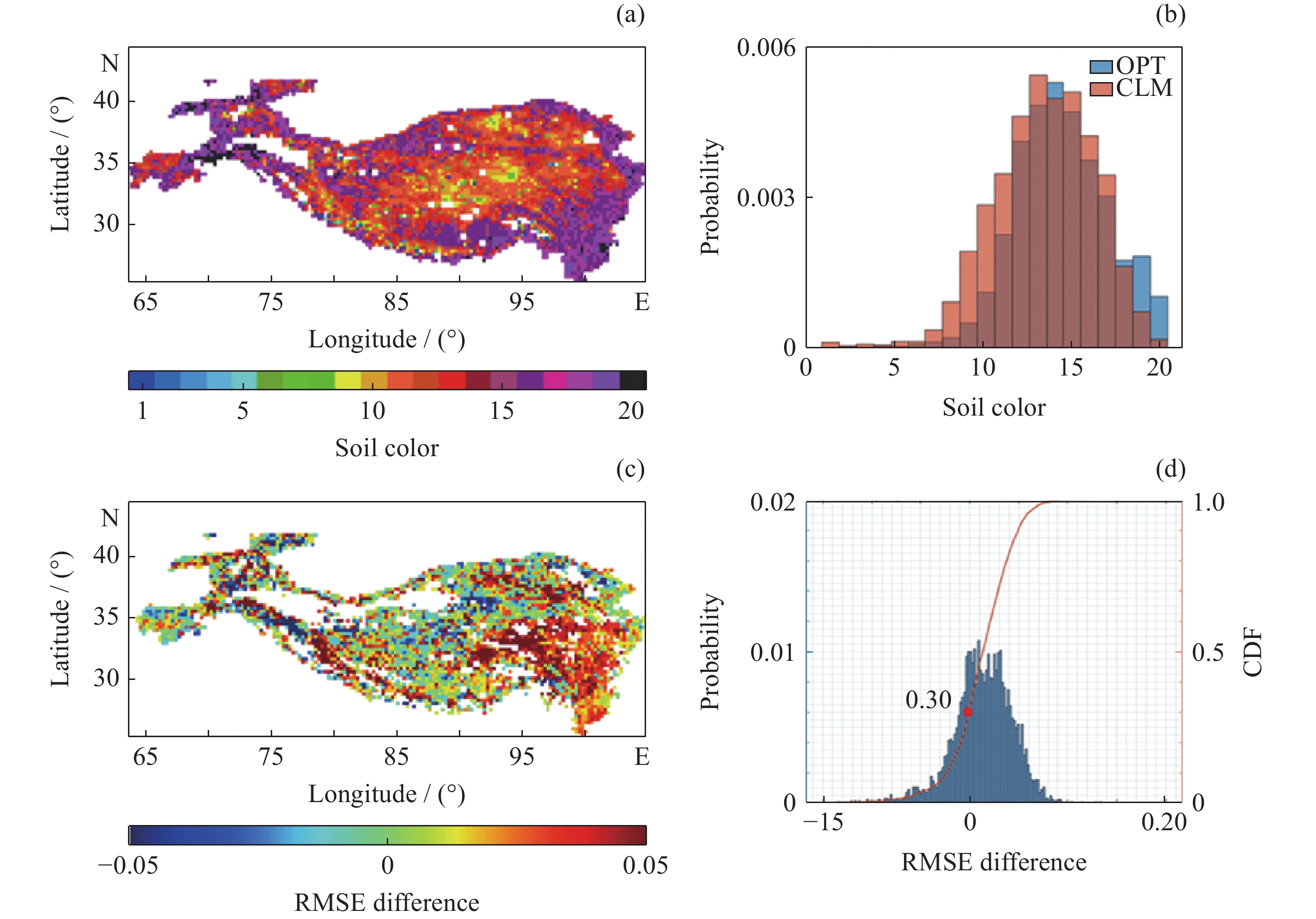
图 6 最优土壤颜色的频率分布(a)及其与不同土壤质地的关系(b~d)
Figure 6. Statistics of optimal soil color (a) and its relationship between different soil texture properties (b~d)
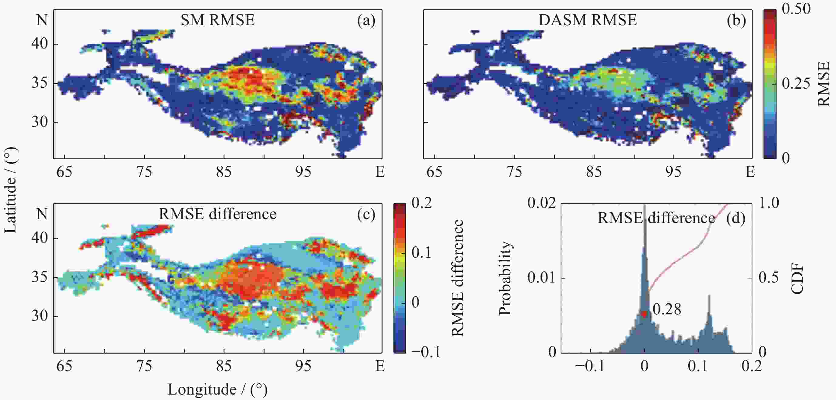
图 7 不同输入条件下模拟反照率与MODIS数据的RMSE空间分布
Figure 7. RMSE spatial distribution between simulated albedo with different input and MODIS products
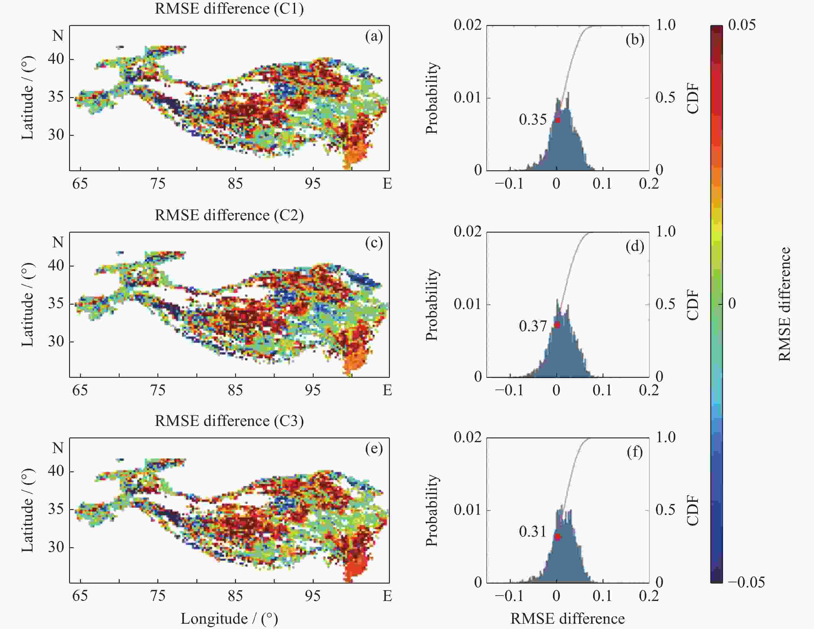
图 8 基于MODIS反照率数据的排除其他因素影响阈值的评估结果
Figure 8. Evaluation results of the threshold that excludes other factors based on MODIS albedo product
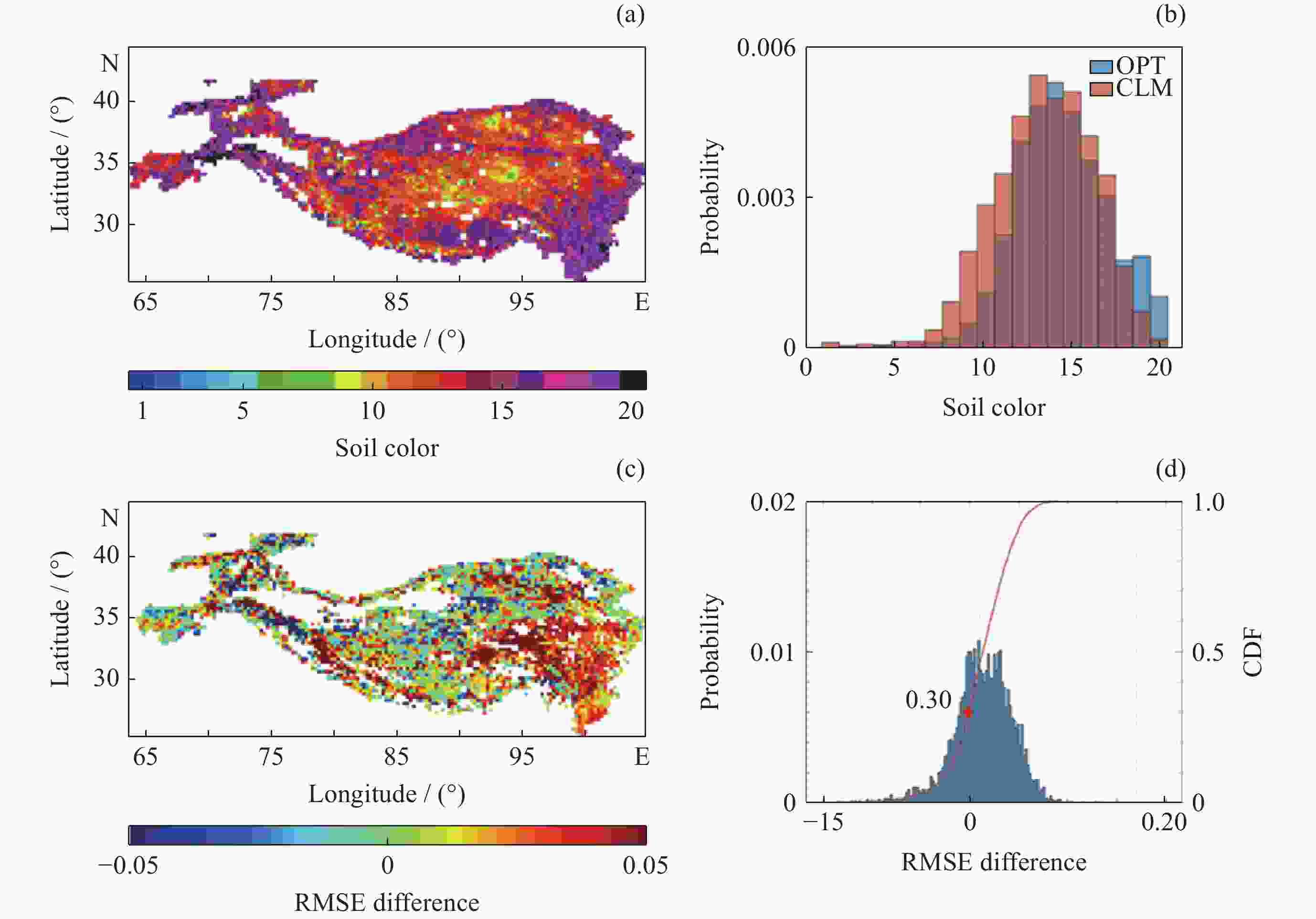
图 9 Lawrence土壤颜色等级优化结果与本研究结果的对比
Figure 9. Comparison between the optimization results of Lawrence soil color grade and the results of this study
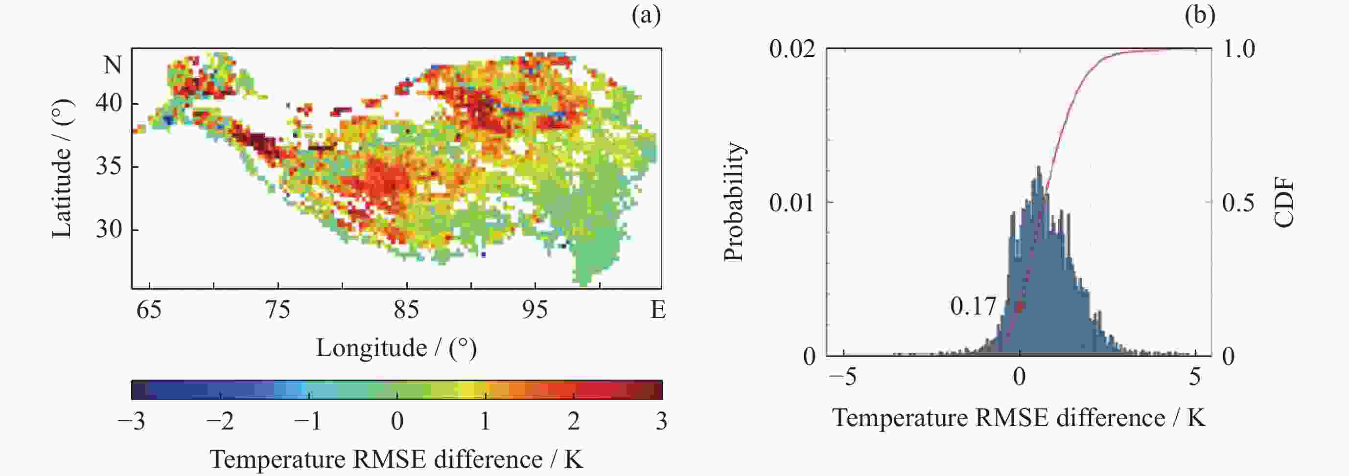
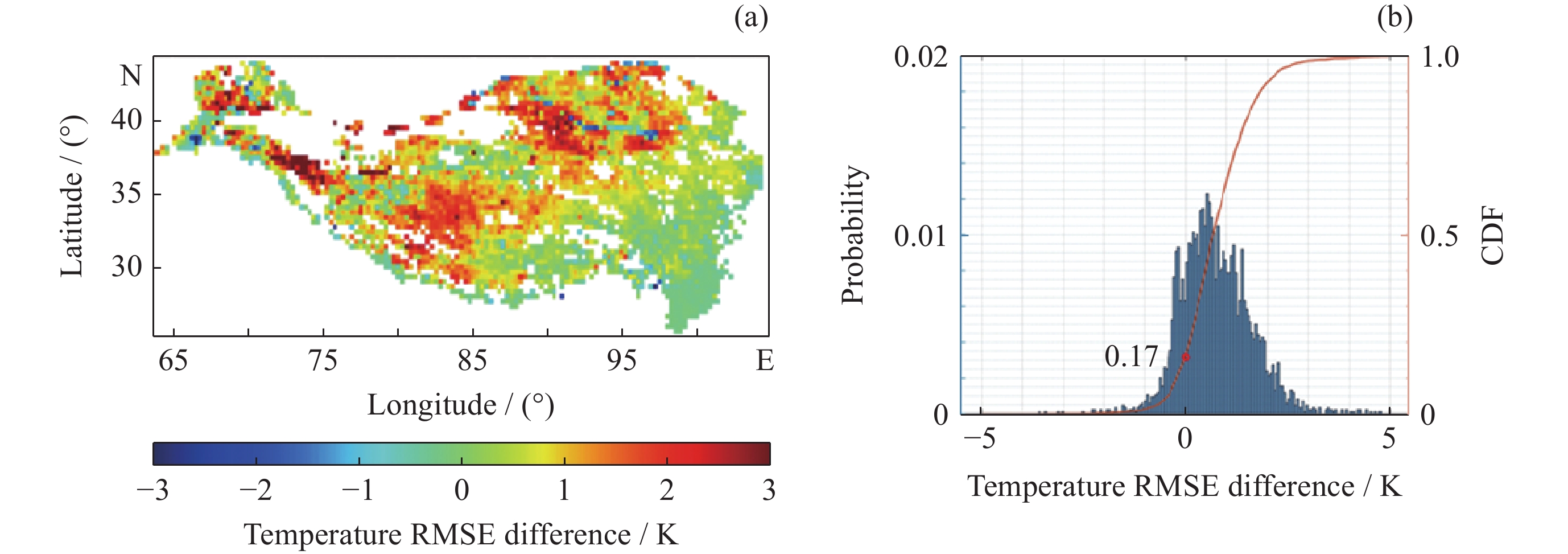
图 10 基于地表温度卫星数据的最优土壤颜色等级评估结果
Figure 10. Evaluation results of optimal soil color based on land surface temperature dataset
表 1 Noah-MP默认土壤颜色等级
Table 1. Soil color in Noah-MP
Soil color 1 2 3 4 5 6 7 8 SAT-VIS 0.15 0.11 0.10 0.09 0.08 0.07 0.06 0.05 SAT-NIR 0.30 0.22 0.20 0.18 0.16 0.14 0.12 0.10 DRY-VIS 0.27 0.22 0.20 0.18 0.16 0.14 0.12 0.10 DRY-NIR 0.54 0.44 0.40 0.36 0.32 0.28 0.24 0.20  下载: 导出CSV
表 2 扩展后的土壤颜色等级
Table 2. Soil color extended
Soil color SAT-VIS SAT-NIR DRY-VIS DRY-NIR 1 0.25 0.50 0.36 0.61 2 0.23 0.46 0.34 0.57 3 0.21 0.42 0.32 0.53 4 0.20 0.40 0.31 0.51 5 0.19 0.38 0.30 0.49 6 0.18 0.36 0.29 0.48 7 0.17 0.34 0.28 0.45 8 0.16 0.32 0.27 0.43 9 0.15 0.30 0.26 0.41 10 0.14 0.28 0.25 0.39 11 0.13 0.26 0.24 0.37 12 0.12 0.24 0.23 0.35 13 0.11 0.22 0.22 0.33 14 0.10 0.20 0.20 0.31 15 0.09 0.18 0.18 0.29 16 0.08 0.16 0.16 0.27 17 0.07 0.14 0.14 0.25 18 0.06 0.12 0.12 0.23 19 0.05 0.10 0.10 0.21 20 0.04 0.08 0.08 0.16 注 SAT-VIS为饱和土壤可见光波段反照率, SAT-NIR为饱和土 壤近红外波段反照率,DRY-VIS为干土可见光波段反照率, DRY-NIR为干土近红外波段反照率。
下载: 导出CSV
-
[1] CHARNEY J, QUIRK W J, CHOW S H, et al. A comparative study of the effects of albedo change on drought in semi-arid regions[J]. Journal of the Atmospheric Sciences, 1977, 34(9): 1366-1385 doi: 10.1175/1520-0469(1977)034<1366:ACSOTE>2.0.CO;2 [2] ELTAHIR E A B. A soil moisture-rainfall feedback mechanism: 1. Theory and observations[J]. Water Resources Research, 1998, 34(4): 765-776 doi: 10.1029/97WR03499 [3] CHAPIN F S. Climate change and the biosphere[J]. The Scientist, 2008, 22(1): 37 [4] BETTS AK, BALL JH, BELJAARS, ACM, MILLERMJ, VITERBO PA. The land surface–atmosphere interaction: a review based on observational and global modelling perspectives[J]. Journal of Geophysical Research-atmospheres, 1996, 101: 7209-7225 doi: 10.1029/95JD02135 [5] ALTON P. A simple retrieval of ground albedo and vegetation absorptance from MODIS satellite data for parameterisation of global Land-Surface Models[J]. Agricultural and Forest Meteorology, 2009, 149(10): 1769-1775 doi: 10.1016/j.agrformet.2009.04.012 [6] HENDERSON-SELLERS A, WILSON M F. Surface albedo data for climatic modeling[J]. Reviews of Geophysics, 1983, 21(8): 1743-1778 doi: 10.1029/RG021i008p01743 [7] EK M B, MITCHELL K E, LIN Y, et al. Implementation of Noah land surface model advances in the National Centers for Environmental Prediction operational mesoscale Eta model[J]. Journal of Geophysical Research: Atmospheres, 2003, 108(D22): 8851 [8] WILSON M F, HENDERSON-SELLERS A. A global archive of land cover and soils data for use in general circulation climate models[J]. Journal of Climatology, 1985, 5(2): 119-143 doi: 10.1002/joc.3370050202 [9] KOSTER R D, SUAREZ M J. The components of a ‘SVAT’ scheme and their effects on a GCM’s hydrological cycle[J]. Advances in Water Resources, 1994, 17(1/2): 61-78 [10] DICKINSON R E, HENDERSON-SELLERS A, KENNEDY P J. Biosphere-Atmosphere Transfer Scheme (BATS) Version 1e as Coupled to the NCAR Community Climate Model[R]. Boulder: NCAR, 1993 [11] SELLERS P J, MINTZ Y, SUD Y C, et al. A simple biosphere model (SIB) for use within general circulation models[J]. Journal of the Atmospheric Sciences, 1986, 43(6): 505-531 doi: 10.1175/1520-0469(1986)043<0505:ASBMFU>2.0.CO;2 [12] GEDNEY N, COX P M, DOUVILLE H, et al. Characterizing GCM land surface schemes to understand their responses to climate change[J]. Journal of Climate, 2000, 13(17): 3066-3079 doi: 10.1175/1520-0442(2000)013<3066:CGLSST>2.0.CO;2 [13] KIEHL J T, HACK J J, BONAN G B, et al. The national center for atmospheric research community climate model: CCM3[J]. Journal of Climate, 1998, 11(6): 1131-1149 doi: 10.1175/1520-0442(1998)011<1131:TNCFAR>2.0.CO;2 [14] WANG Z, ZENG X, BARLAGE M, et al. Using MODIS BRDF and albedo data to evaluate global model land surface albedo[J]. Journal of Hydrometeorology, 2004, 5(1): 3-14 doi: 10.1175/1525-7541(2004)005<0003:UMBAAD>2.0.CO;2 [15] LAWRENCE D M, SLINGO J M. An annual cycle of vegetation in a GCM. Part II: global impacts on climate and hydrology[J]. Climate Dynamics, 2004, 22(2/3): 107-122 [16] SHI Y, YU M, ERFANIAN A, et al. Modeling the dynamic vegetation-climate system over China using a coupled regional model[J]. Journal of Climate, 2018, 31(15): 6027-6049 doi: 10.1175/JCLI-D-17-0191.1 [17] WARREN S G, WISCOMBE W J. A model for the spectral albedo of snow. II: snow containing atmospheric aerosols[J]. Journal of the Atmospheric Sciences, 1980, 37(12): 2734-2745 doi: 10.1175/1520-0469(1980)037<2734:AMFTSA>2.0.CO;2 [18] WISCOMBE W J, WARREN S G. A model for the spectral albedo of snow. I: pure snow[J]. Journal of the Atmospheric Sciences, 1980, 37(12): 2712-2733 doi: 10.1175/1520-0469(1980)037<2712:AMFTSA>2.0.CO;2 [19] JONSELL U, HOCK R, HOLMGREN B. Spatial and temporal variations in albedo on Storglaciären, Sweden[J]. Journal of Glaciology, 2003, 49(164): 59-68 doi: 10.3189/172756503781830980 [20] HANSEN J, NAZARENKO L. Soot climate forcing via snow and ice albedos[J]. Proceedings of the National Academy of Sciences of the United States of America, 2003, 101(2): 423-428 [21] BAO Y, LÜ S H, ZHANG Y, et al. Improvement of surface albedo simulations over arid regions[J]. Advances in Atmospheric Sciences, 2008, 25(3): 481-488 doi: 10.1007/s00376-008-0481-y [22] PARK S, PARK S K. Parameterization of the snow-covered surface albedo in the Noah-MP Version 1.0 by implementing vegetation effects[J]. Geoscientific Model Development, 2016, 9(3): 1073-1085 doi: 10.5194/gmd-9-1073-2016 [23] ZHONG E F, LI Q, SUN S F, et al. Improvement of a snow albedo parameterization in the Snow-Atmosphere-Soil Transfer model: evaluation of impacts of aerosol on seasonal snow cover[J]. Advances in Atmospheric Sciences, 2017, 34(11): 1333-1345 doi: 10.1007/s00376-017-7019-0 [24] MIAO X, GUO W D, QIU B, et al. Accounting for topographic effects on snow cover fraction and surface albedo simulations over the Tibetan Plateau in winter[J]. Journal of Advances in Modeling Earth Systems, 2022, 14(8): e2022MS003035 doi: 10.1029/2022MS003035 [25] HOULDCROFT C J, GREY W M F, BARNSLEY M, et al. New vegetation albedo parameters and global fields of soil background albedo derived from MODIS for use in a climate model[J]. Journal of Hydrometeorology, 2009, 10(1): 183-198 doi: 10.1175/2008JHM1021.1 [26] LAWRENCE P J, CHASE T N. Representing a new MODIS consistent land surface in the Community Land Model (CLM 3.0)[J]. Journal of Geophysical Research: Biogeosciences, 2007, 112(G1): G01023 [27] YANG Z L, NIU G Y, MITCHELL K E, et al. The community Noah land surface model with multiparameterization options (Noah-MP): 2. Evaluation over global river basins[J]. Journal of Geophysical Research: Atmospheres, 2011, 116(D12): D12110 doi: 10.1029/2010JD015140 [28] ZHAO L, YANG K, HE J, et al. Potential of mapping global soil texture type from SMAP soil moisture product: a pilot study[J]. IEEE Transactions on Geoscience and Remote Sensing, 2022, 60: 4406410 [29] CAI X T, YANG Z L, DAVID C H, et al. Hydrological evaluation of the Noah-MP land surface model for the Mississippi River Basin[J]. Journal of Geophysical Research: Atmospheres, 2014, 119(1): 23-38 doi: 10.1002/2013JD020792 [30] HE C, VALAYAMKUNNATH P, BARLAGE M, et al. The Community Noah-MP Land Surface Modeling System Technical Description Version 5.0[R]. Boulder: NCAR, 2023. DOI: 10.5065/ew8g-yr95 [31] WANG Z S, SCHAAF C B, SUN Q S, et al. Capturing rapid land surface dynamics with Collection V006 MODIS BRDF/NBAR/Albedo (MCD43) products[J]. Remote Sensing of Environment, 2018, 207: 50-64 doi: 10.1016/j.rse.2018.02.001 [32] SCHAAF C, WANG Z. MCD43C3 MODIS/Terra+Aqua BRDF/Albedo Albedo Daily L3 Global 0.05Deg CMG V006[OL]. [2023-07-30]. https://doi.org/10.5067/MODIS/MCD43C3.006 [33] HE J, YANG K, TANG W J, et al. The first high-resolution meteorological forcing dataset for land process studies over China[J]. Scientific Data, 2020, 7(1): 25 doi: 10.1038/s41597-020-0369-y [34] 田佳鑫, 卢麾, 阳坤, 等. 基于扩展卡尔曼滤波和自动微分技术对陆面数据同化系统参数的快速估计及其影响[J]. 中国科学: 地球科学, 2023, 53 (11): 2591-2608TIAN J X, LU H, YANG K, et al. Quick estimation of parameters for the land surface data assimilation system and its influence based on the extended Kalman filter and automatic differentiation[J]. Science China Earth Sciences, 2023, 66 (11): 2546-2562 [35] XIAO Z Q, LIANG S L, WANG J D, et al. Long-time-series global land surface satellite leaf area index product derived from MODIS and AVHRR surface reflectance[J]. IEEE Transactions on Geoscience and Remote Sensing, 2016, 54(9): 5301-5318 doi: 10.1109/TGRS.2016.2560522 [36] PAN J M, YANG J W, JIANG L M, et al. Combination of snow process model priors and site representativeness evaluation to improve the global snow depth retrieval based on passive microwaves[J]. IEEE Transactions on Geoscience and Remote Sensing, 2023, 61: 4301120 [37] DAI Y J, CoLM Team. CoLM (Common Land Model) Version 2014, Model Item, OpenGMS[OL]. [2023-07-30]. https://geomodeling.njnu.edu.cn/modelItem/7b12e874-c7cb-4c2d-b9d3-e5017167da1d [38] YU P, ZHAO T J, SHI J C, et al. Global spatiotemporally continuous MODIS land surface temperature dataset[J]. Scientific Data, 2022, 9(1): 143 doi: 10.1038/s41597-022-01214-8 [39] BORMANN H. Towards a hydrologically motivated soil texture classification[J]. Geoderma, 2010, 157(3/4): 142-153 [40] WAGGONER D G, SOKOLIK I N. Seasonal dynamics and regional features of MODIS-derived land surface characteristics in dust source regions of East Asia[J]. Remote Sensing of Environment, 2010, 114(10): 2126-2136 doi: 10.1016/j.rse.2010.04.017 [41] IDSO S B, JACKSON R D, REGINATO R J, et al. The dependence of bare soil albedo on soil water content[J]. Journal of Applied Meteorology, 1975, 14(1): 109-113 doi: 10.1175/1520-0450(1975)014<0109:TDOBSA>2.0.CO;2 [42] GASCOIN S, DUCHARNE A, RIBSTEIN P, et al. Sensitivity of bare soil albedo to surface soil moisture on the moraine of the Zongo glacier (Bolivia)[J]. Geophysical Research Letters, 2009, 36(2): L02405 [43] 郑志远, 韦志刚, 李振朝, 等. 敦煌荒漠戈壁地区裸土地表反照率参数化研究[J]. 大气科学, 2014, 38(2): 297-308 doi: 10.3878/j.issn.1006-9895.2013.13147ZHENG Zhiyuan, WEI Zhigang, LI Zhenchao, et al. Study of parameterization of surface albedo of bare soil over the Gobi desert in the Dunhuang region[J]. Chinese Journal of Atmospheric Sciences, 2014, 38(2): 297-308 doi: 10.3878/j.issn.1006-9895.2013.13147 -
-

 下载:
下载:


计量
- 文章访问数: 1410
- HTML全文浏览量: 523
- PDF下载量: 67
-
被引次数:
0(来源:Crossref)
0(来源:其他)

