


风云三号E星GNSS-R反演有效波高敏感性分析
doi: 10.11728/cjss2025.02.2024-0093 cstr: 32142.14.cjss.2024-0093
-
 黄飞雄 男, 1992年4月出生于湖北省武汉市, 现为中国科学院国家空间科学中心副研究员, 硕士生导师, 主要研究方向为星载GNSS-R数据定标、海洋遥感及其同化应用. E-mail: huangfeixiong@nssc.ac.cn
 -
 夏俊明 男, 1986年2月出生于河南省新乡市, 现为中国科学院国家空间科学中心副研究员, 硕士生导师, 主要研究方向为GNSS反射信号遥感技术与应用. E-mail: xiajunming@nssc.ac.cn
作者简介:
Sensitivity Analysis on the Retrieval of Significant Wave Height Using Fengyun-3E GNSS-R
-
摘要: 星载全球导航卫星反射遥感(GNSS-R)是一种利用导航卫星L波段信号前向准镜面反射的新型海洋遥感技术. 通过对比GNSS-R技术与其他微波遥感技术的异同, 在测量方法上提出了两种GNSS-R反演有效波高的技术路线. 一种为基于GNSS-R归一化时延波形前沿斜率的直接测量方法, 另一种为基于GNSS-R海面粗糙度的间接测量方法. 通过理论分析, 结合风云三号E星实测数据, 分析了两种方法的可行性和敏感性. 结果表明, 受限于当前体制下的GNSS信号带宽, GNSS-R测距精度不足, 其波形前沿斜率对有效波高几乎无敏感性, 无法用于反演; GNSS-R测量的海面粗糙度可以用于反演有效波高, 精度为0.5~0.55 m, 虽然也存在一定的局限性, 但可作为一种获取有效波高数据的良好补充手段. 研究结果可为后续GNSS-R卫星任务的设计提供指导.
-
关键词:
- 全球导航卫星系统反射遥感 /
- 有效波高 /
- 敏感性分析 /
- 海面粗糙度
Abstract: The Global Navigation Satellite System Reflectometry (GNSS-R) is a new ocean remote sensing technique using L-band forward quasi-specular scattering navigation signals. After comparing the similarities and differences between GNSS-R and other microwave remote sensing techniques, two methods of retrieving Significant Wave Height (SWH) by GNSS-R are proposed: one is a direct method using the leading edge slope of the normalized delay waveform; the other is indirect based on the sea surface roughness measurement. The feasibility and sensitivity of the two methods are analyzed through theoretical model and actual measurements from Fengyun-3E data. The results show that due to the low ranging accuracy from GNSS signals bandwidth, the leading edge slope is almost insensitive to SWH, which cannot be used for retrieval; the sea surface roughness from GNSS-R can be used to retrieve SWH with an accuracy of about 0.5~0.55 m. Although it still has some limitations, it can be used as a good supplementary means to obtain SWH data. The results of this paper can also provide guidance for the design of future GNSS-R satellite missions.-
Key words:
- GNSS-R /
- Significant wave height /
- Sensitivity analysis /
- Ocean surface roughness
-
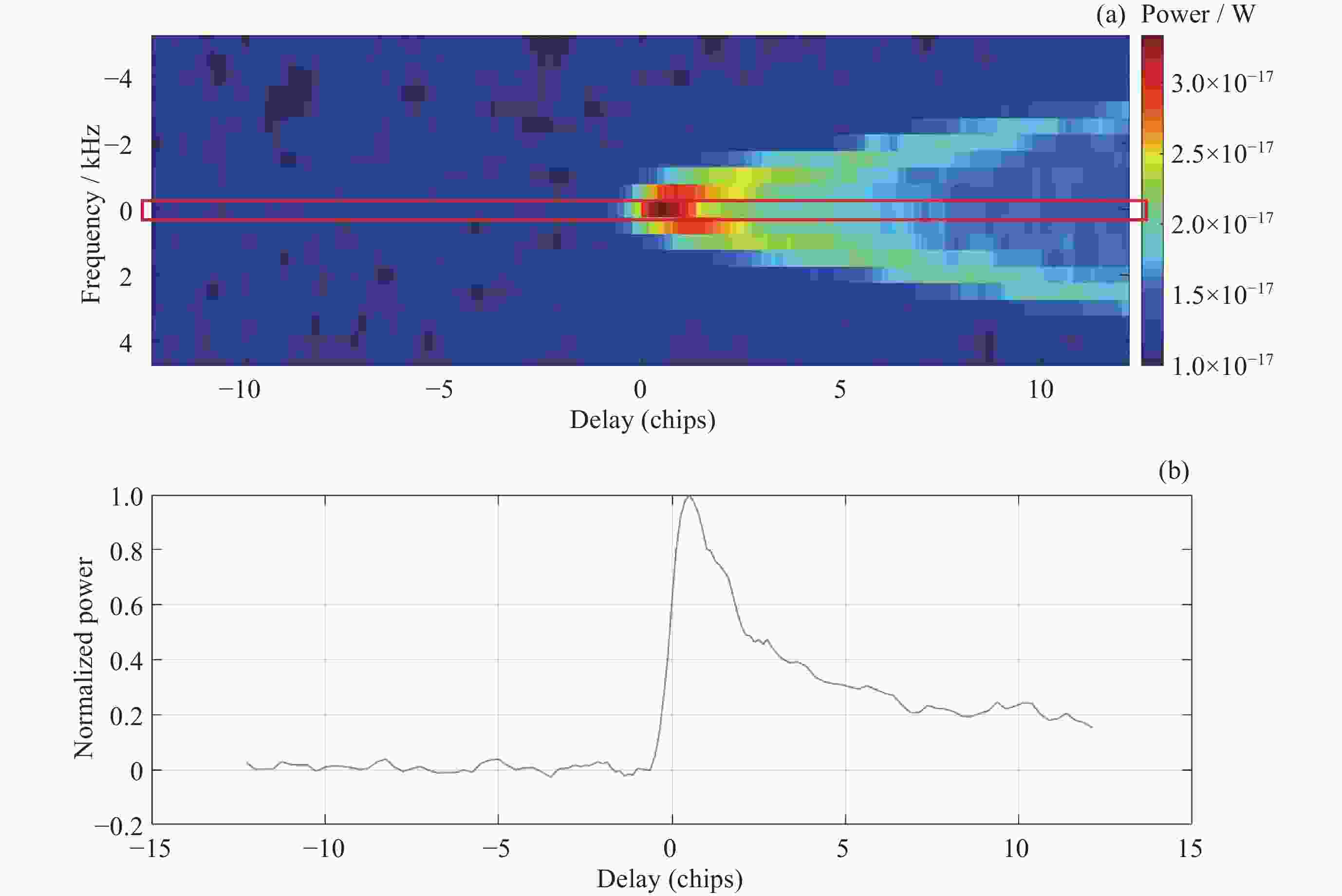
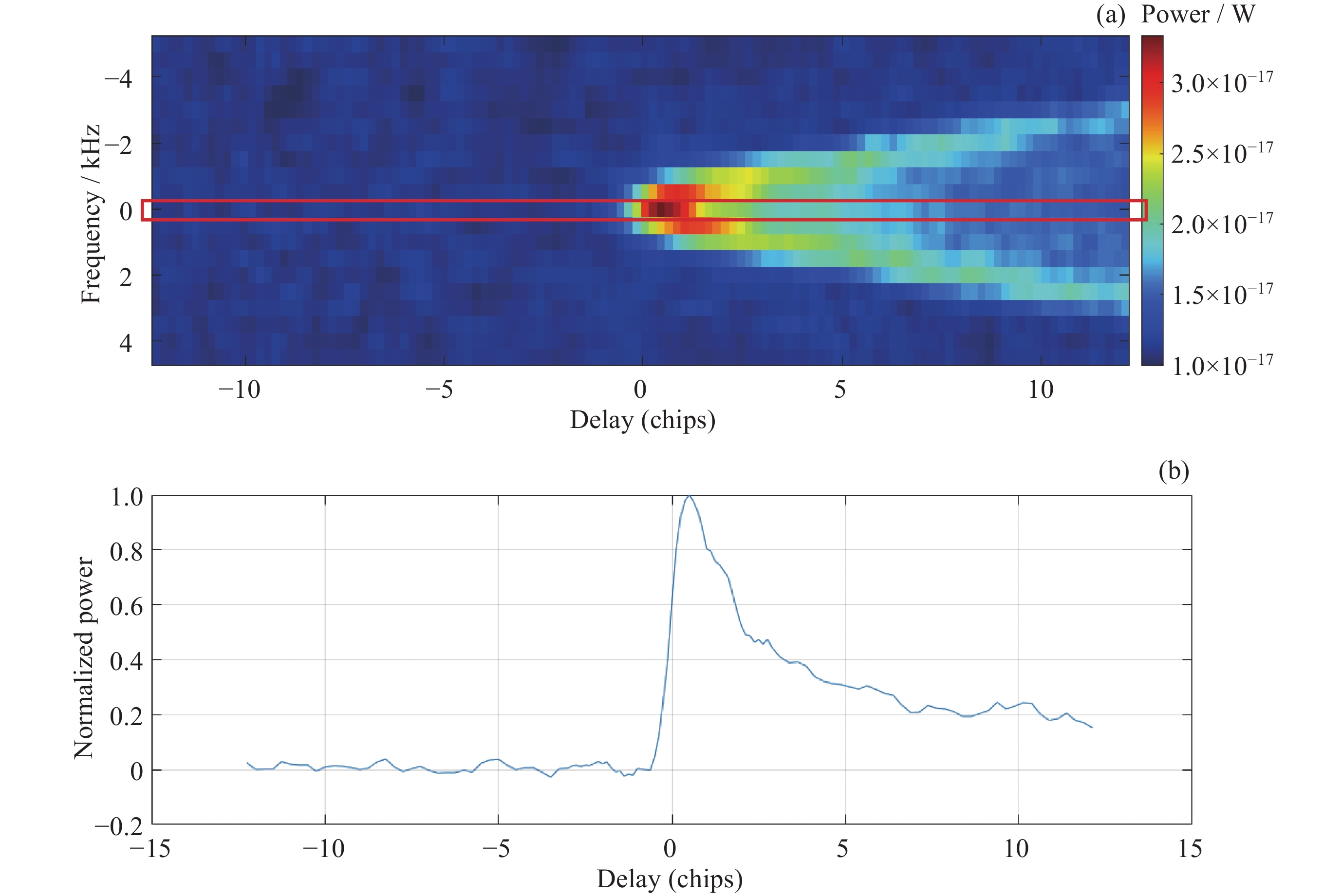
图 1 星载GNSS-R DDM二维波形(a)与从DDM中提取的归一化一维波形(b)
Figure 1. Spaceborne GNSS-R DDM two-dimensional waveform (a) and the one dimensional waveform extracted from the DDM (b)
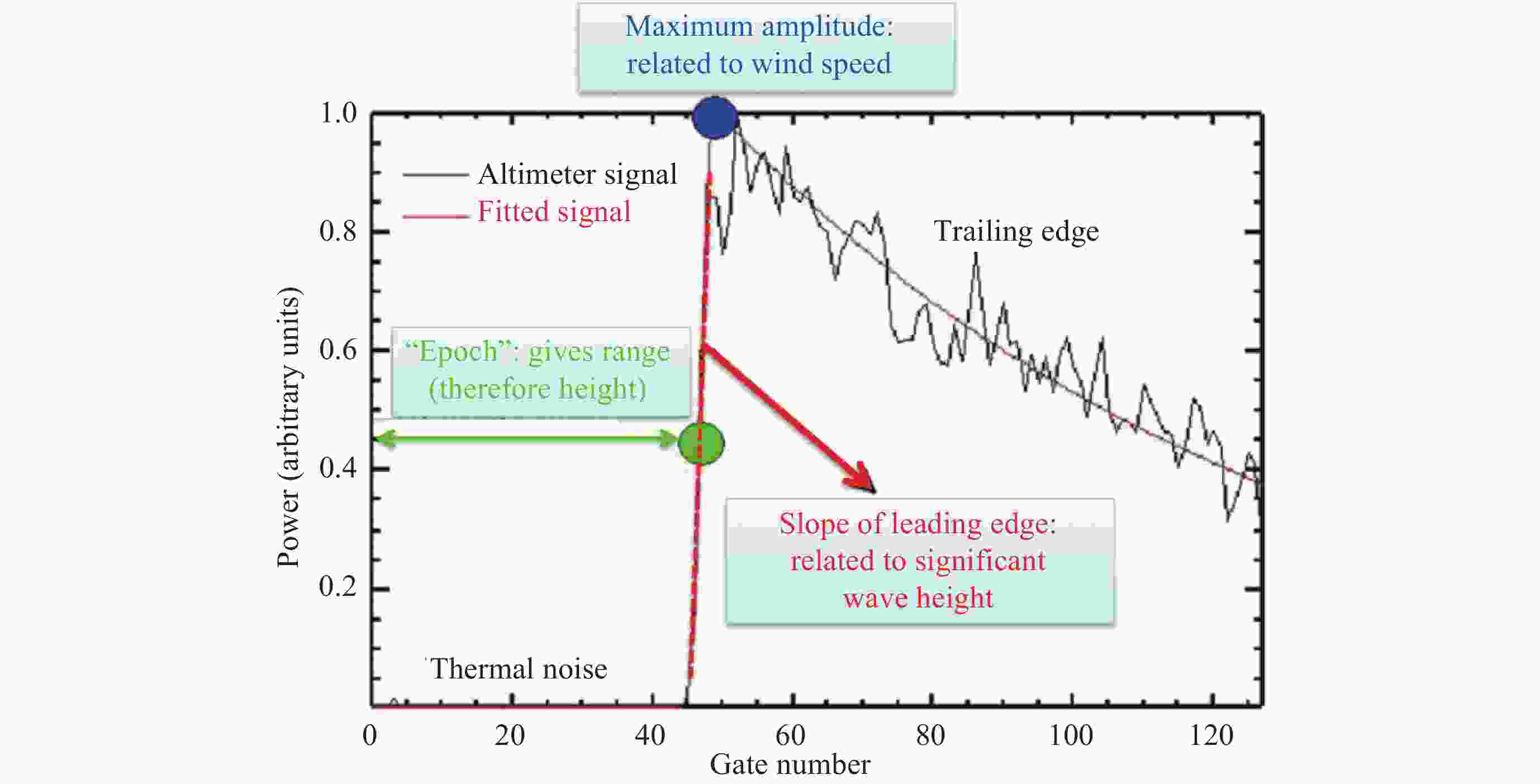
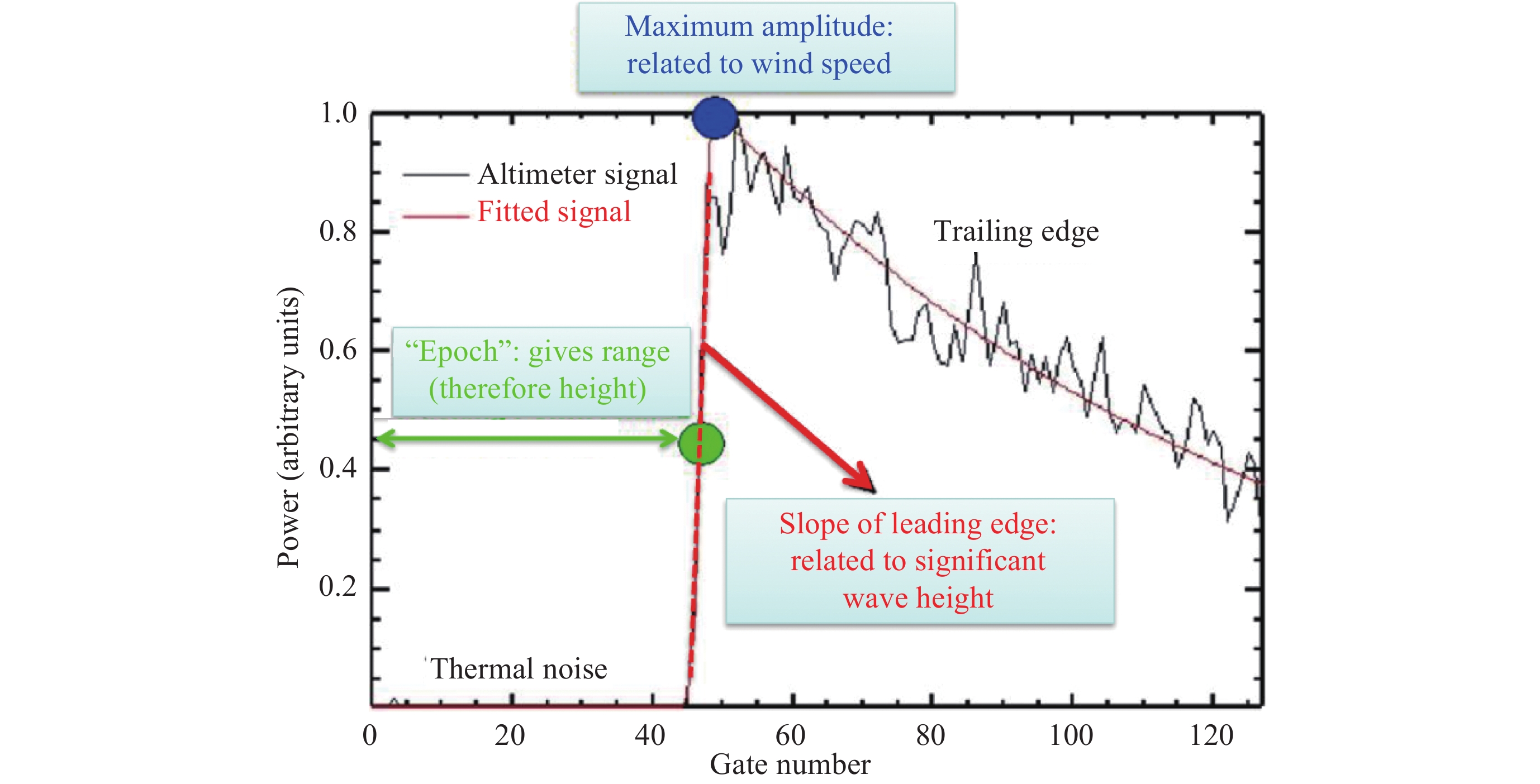
图 2 雷达高度计波形及反演海面高度、海面风速、有效波高的观测量
Figure 2. Radar altimeter waveform and observations of sea surface height, sea surface wind speed and significant wave height
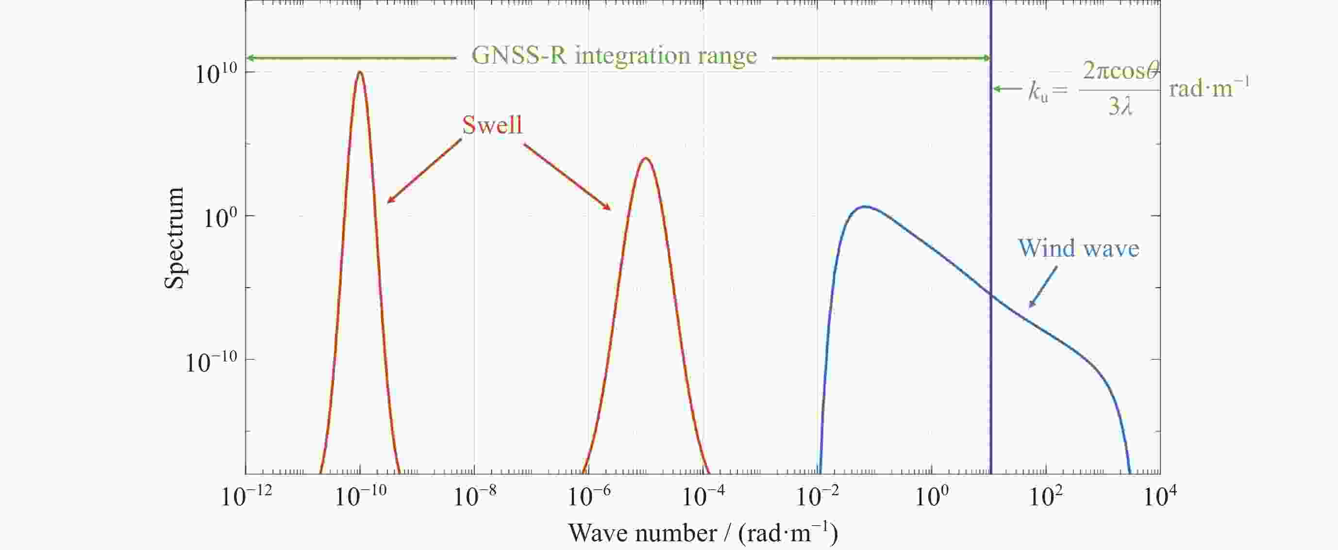
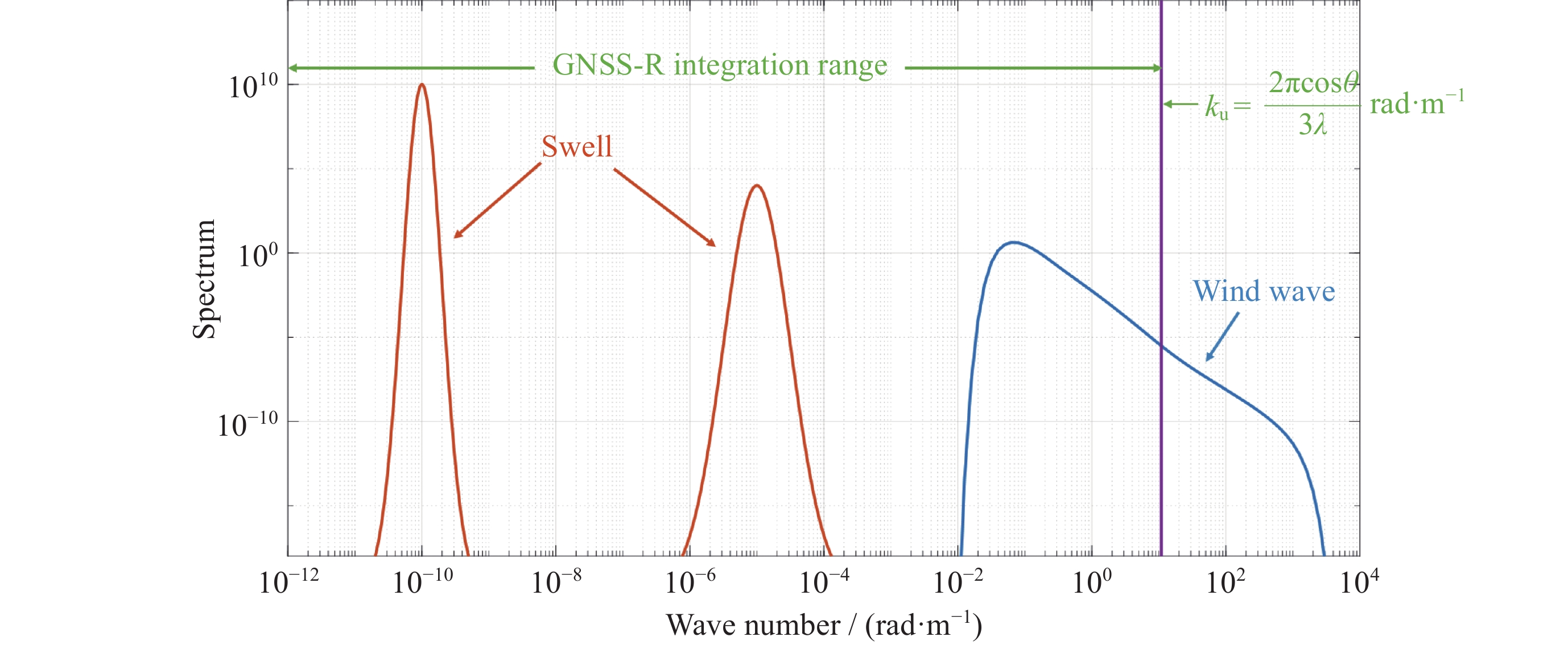
图 3 GNSS-R MSS的计算以及与涌浪、风浪海浪谱的关系
Figure 3. Calculation of GNSS-R MSS and its relationship with the spectrums of swell and wind
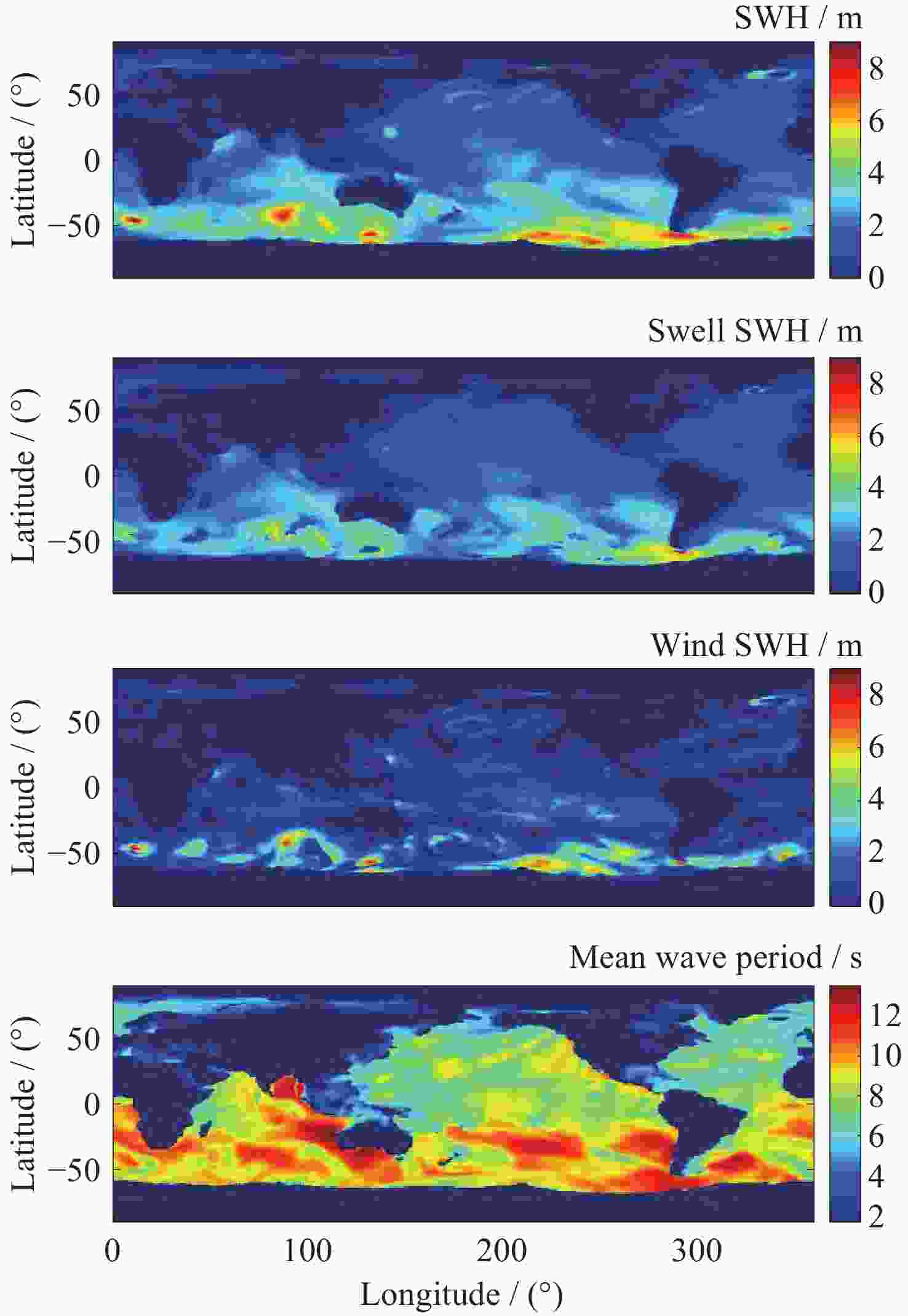
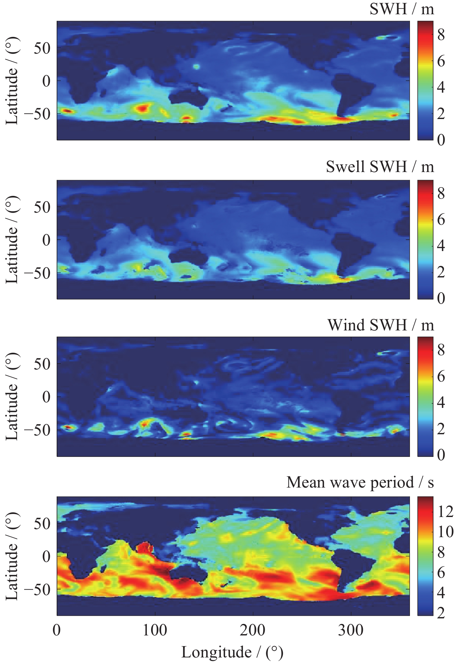
图 4 2022年7月28日00:00 UT时ECWMF ERA5的整体有效波高、涌浪有效波高、风浪有效波高和平均海浪周期
Figure 4. Total SWH, swell SWH, wind SWH and mean wave period from ECMWF ERA5 at 00:00 UT on 28 July 2022
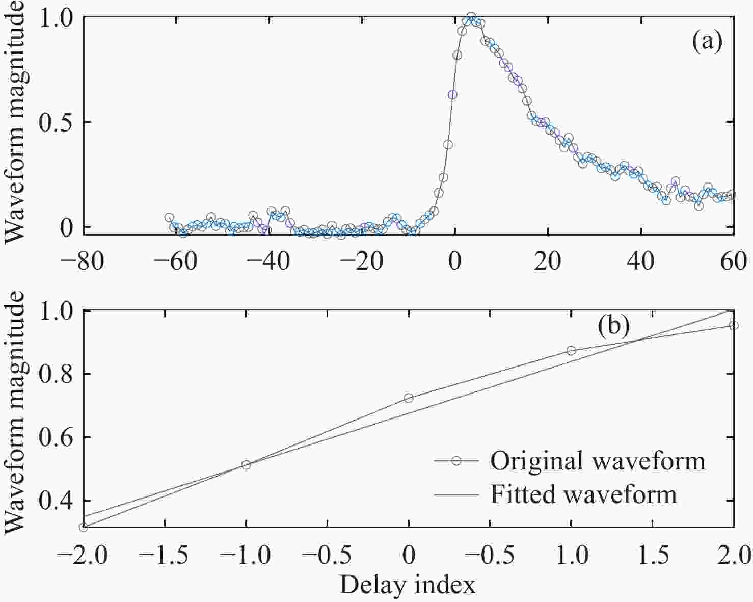
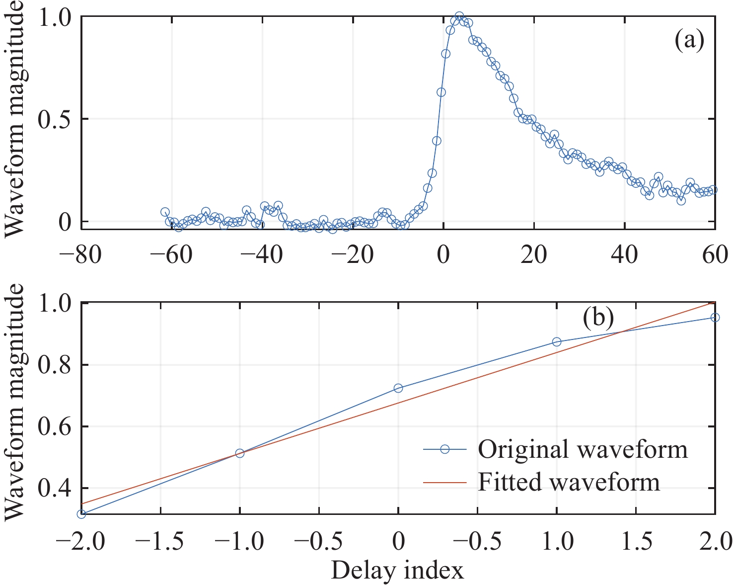
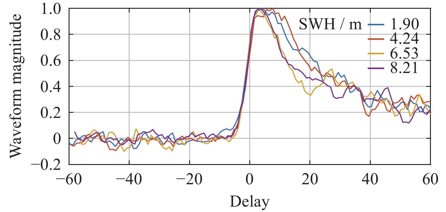
图 5 GNSS-R一维时延波形(a)与镜面反射点附近原始一维时延波形与拟合后波形(b)
Figure 5. GNSS-R one dimensional delay waveform (a), GNSS-R original waveform and fitted waveform near the specular point (b)
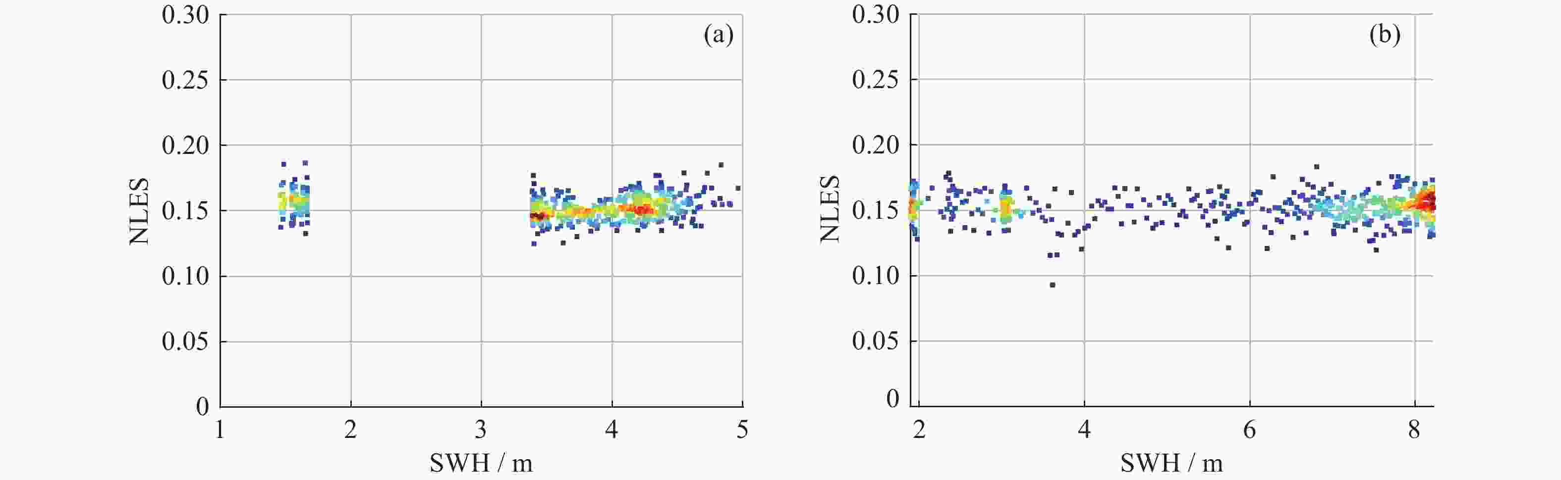
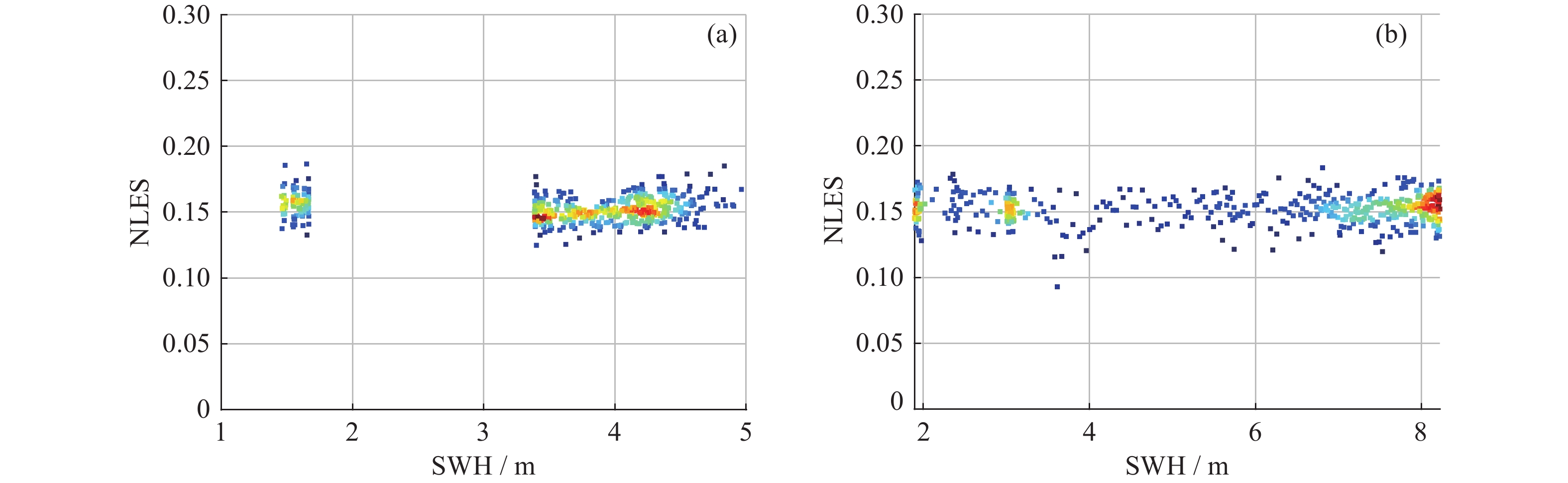
图 7 归一化波形前沿斜率与有效波高的散点密度. (a) 2022年7月10日19:00 UT-20:00 UT数据, (b) 2022年7月29日13:00 UT-14:00 UT 数据
Figure 7. Scatter density plots for the comparison between NLES and SWH. (a) Data at 19:00 UT-20:00 UT on 10 July 2022, (b) data at 13:00 UT-14:00 UT on 29 July 2022
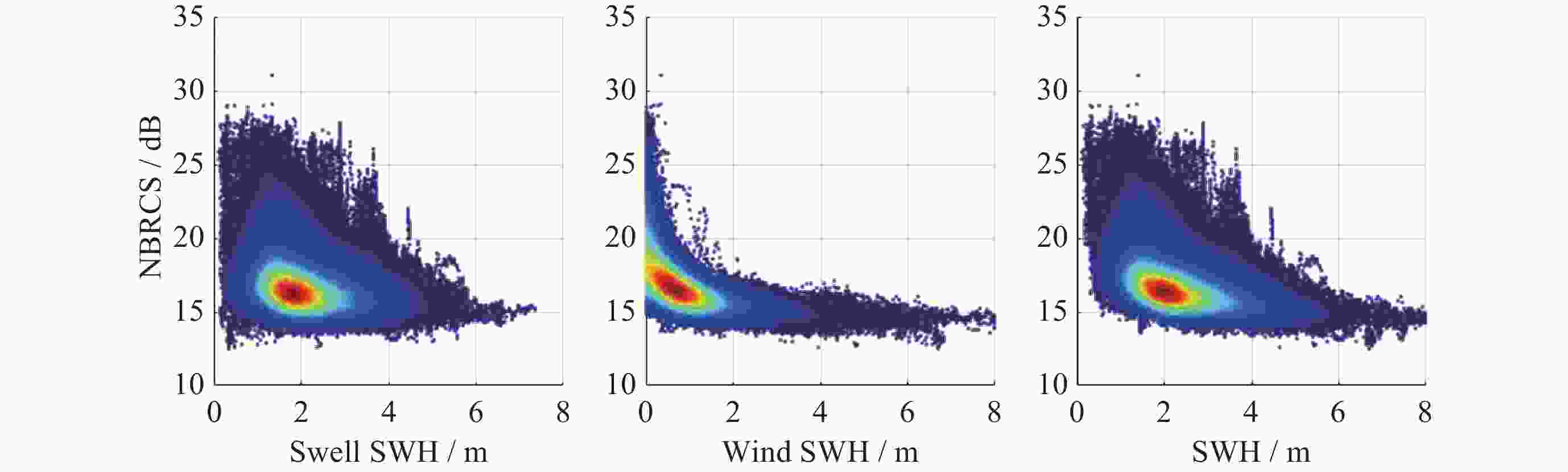
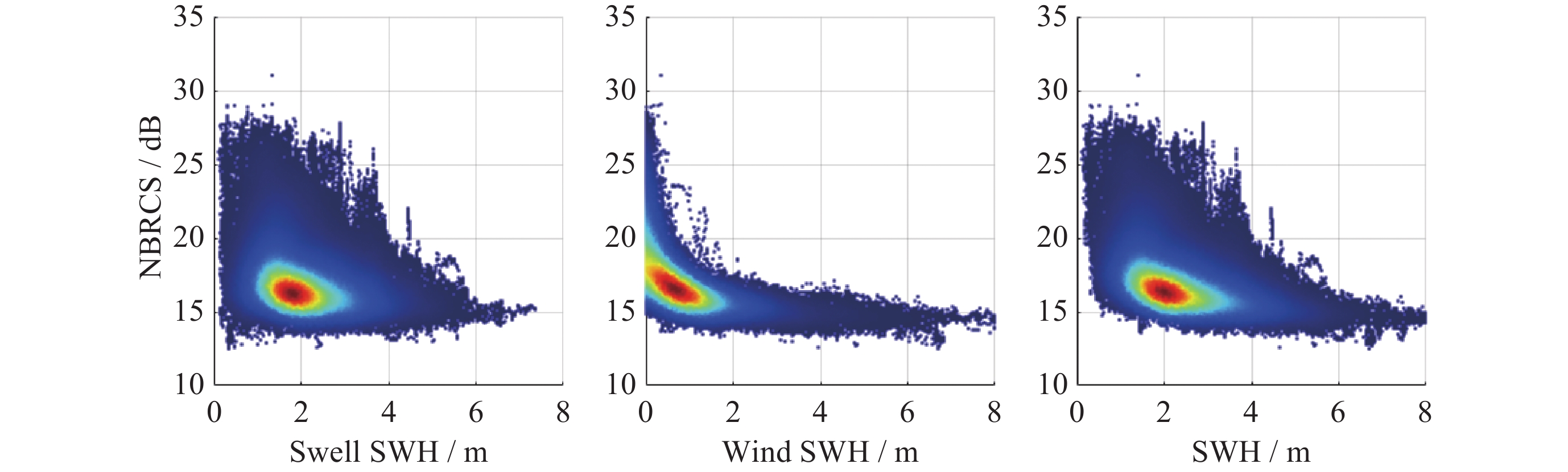
图 8 FY-3E NBRCS与涌浪有效波高、风浪有效波高、整体有效波高的散点密度
Figure 8. Density scatter plots for the comparison between FY-3E NBRCS and swell, wind and total SWH
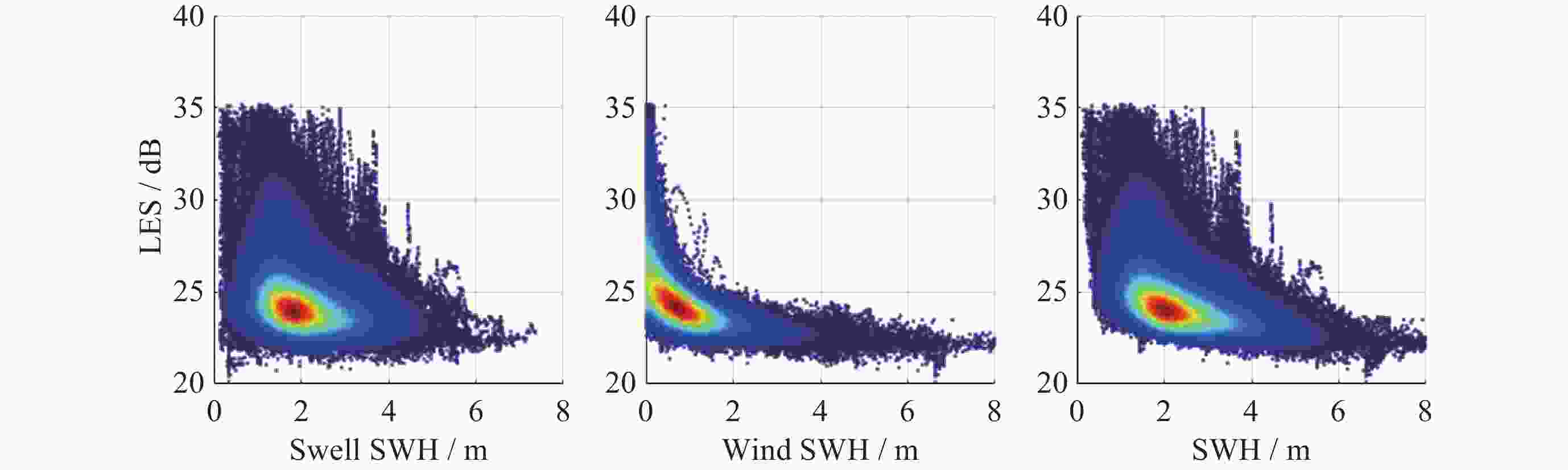
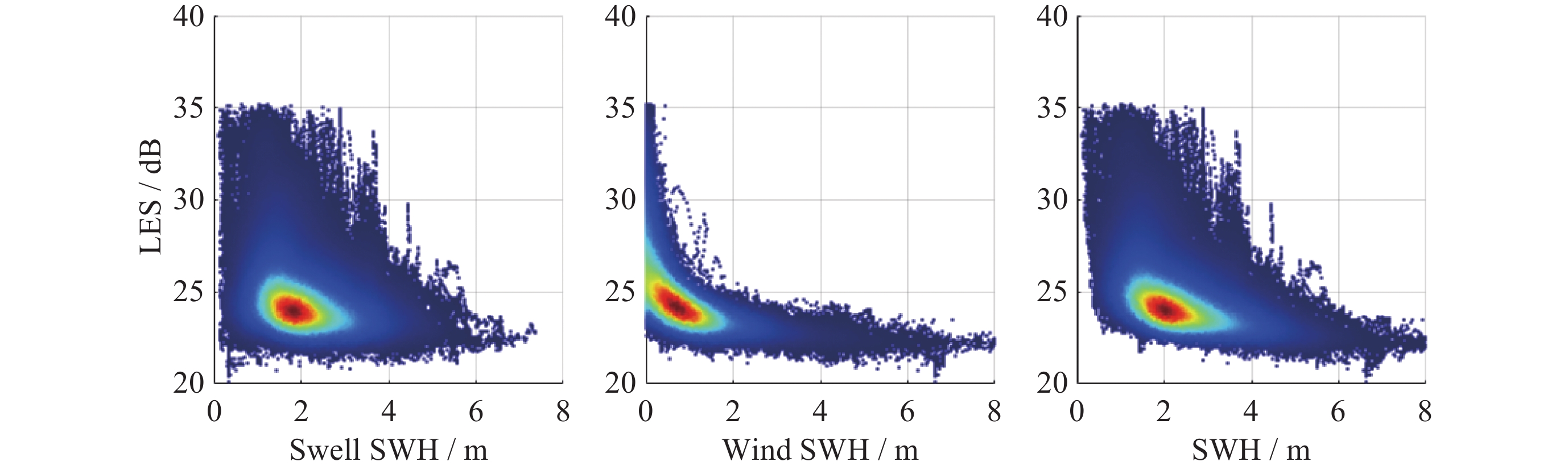
图 9 FY-3E LES与涌浪有效波高、风浪有效波高、整体有效波高的散点密度
Figure 9. Density scatter plots for the comparison between FY-3E LES and swell, wind and total SWH
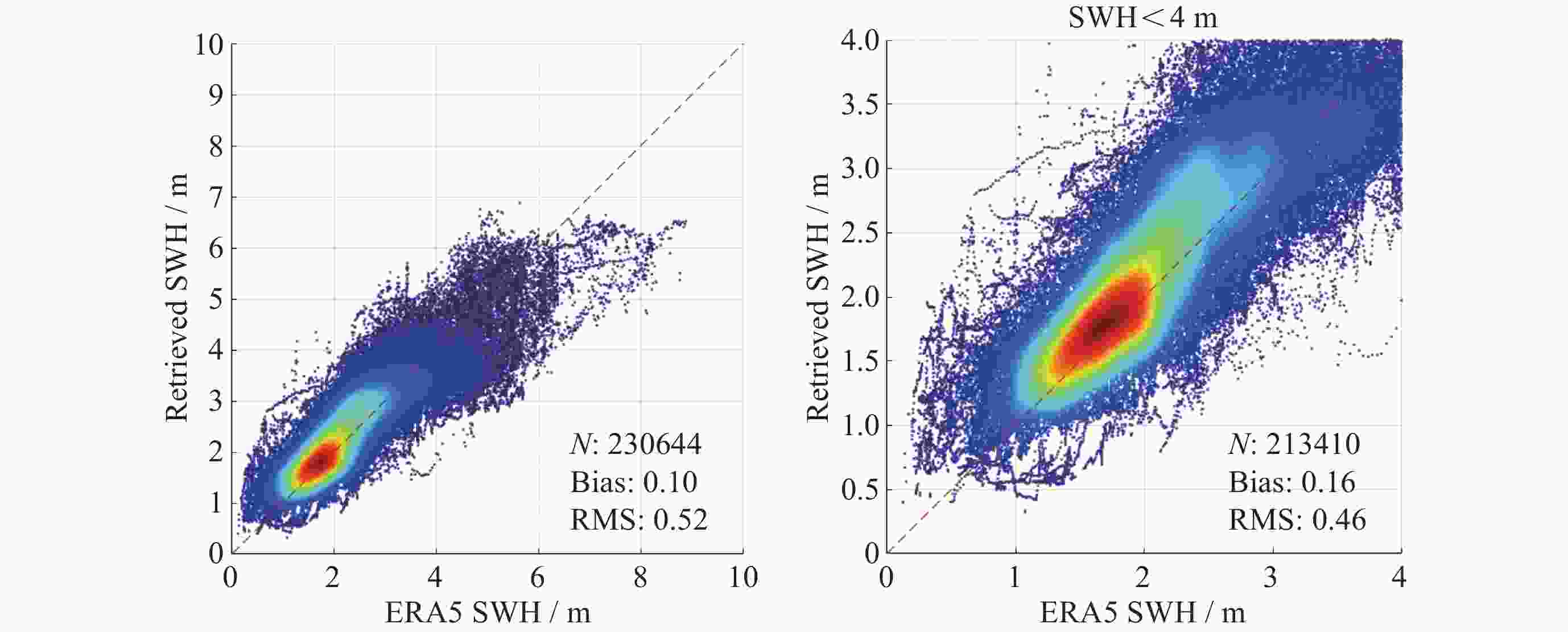
图 10 GNSS-R反演有效波高与ECMWF ERA5有效波高对比的散点密度. (a)整体对比, (b) 4 m以下对比
Figure 10. Density scatter plots for the comparison of between SWH retrieved by GNSSR and ECMWF ERA5 SWH. (a) Overall comparison, (b) SWH under 4 m
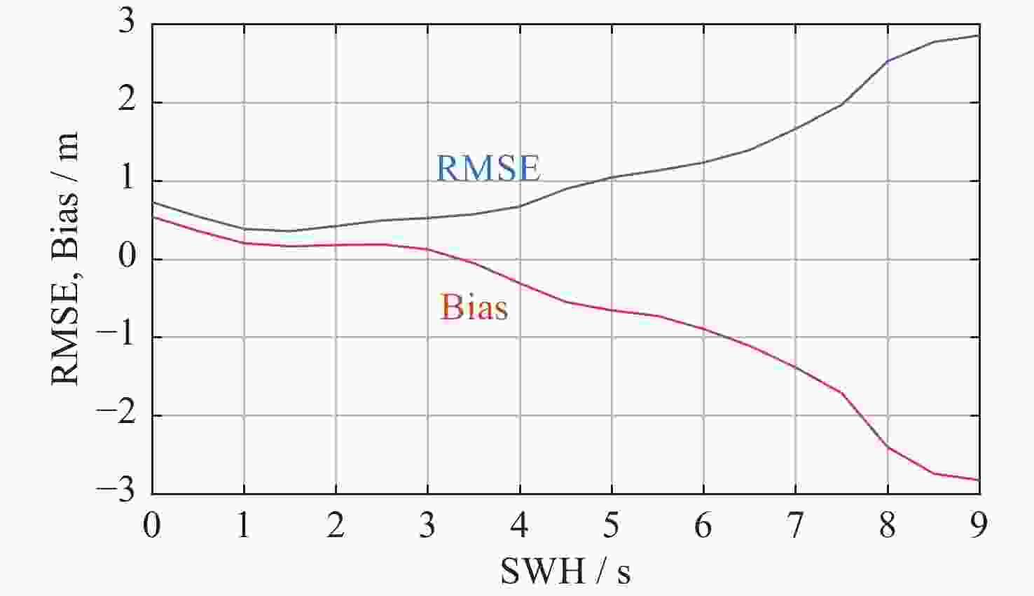
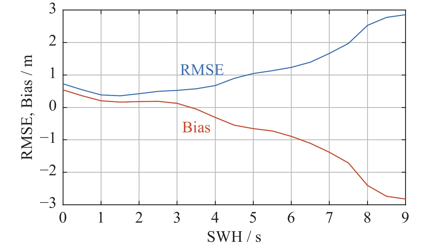
图 11 GNSS-R有效波高反演精度与ERA5有效波高的关系
Figure 11. SWH retrieval statistics as a function of ERA5 SWH
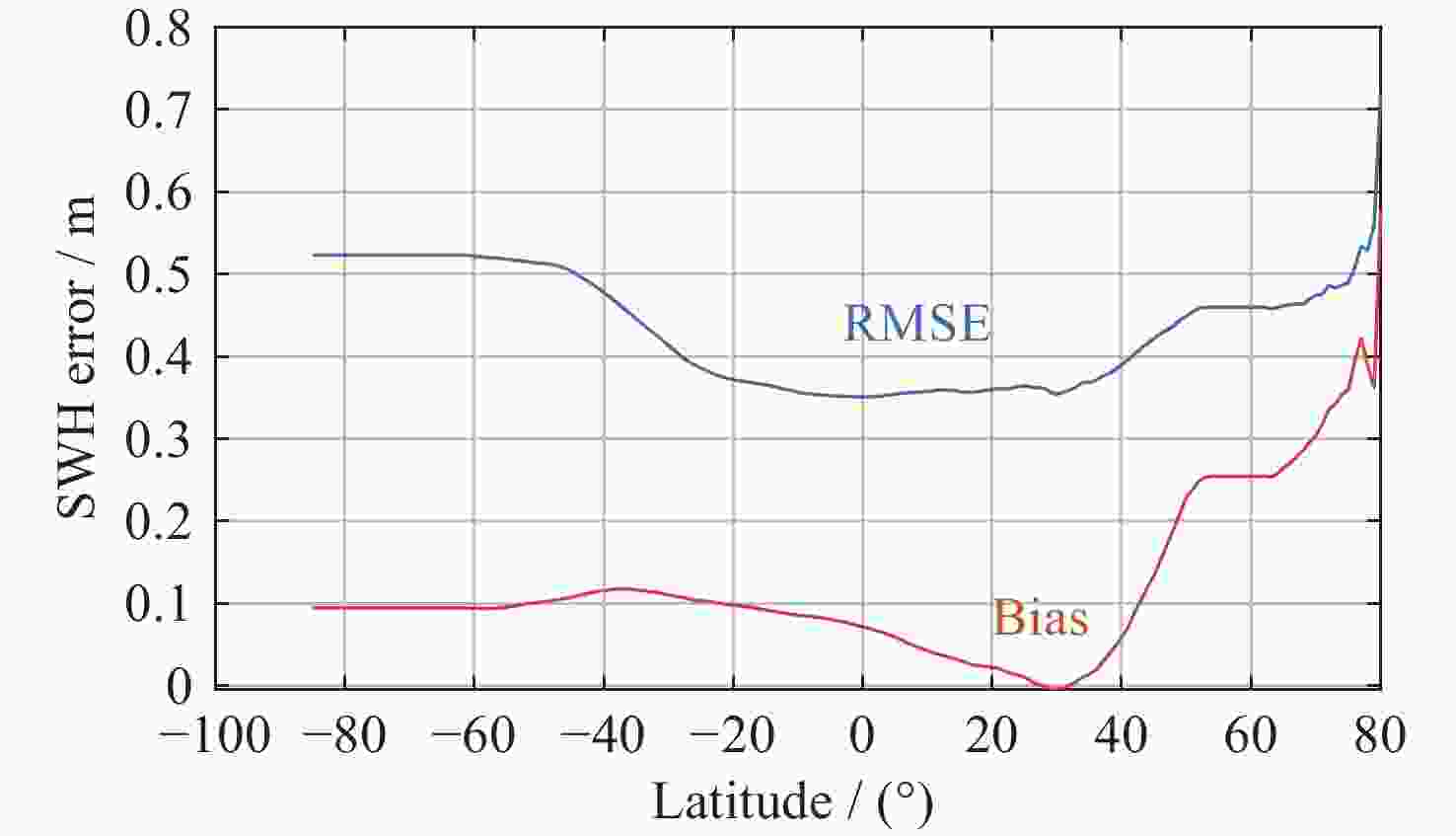
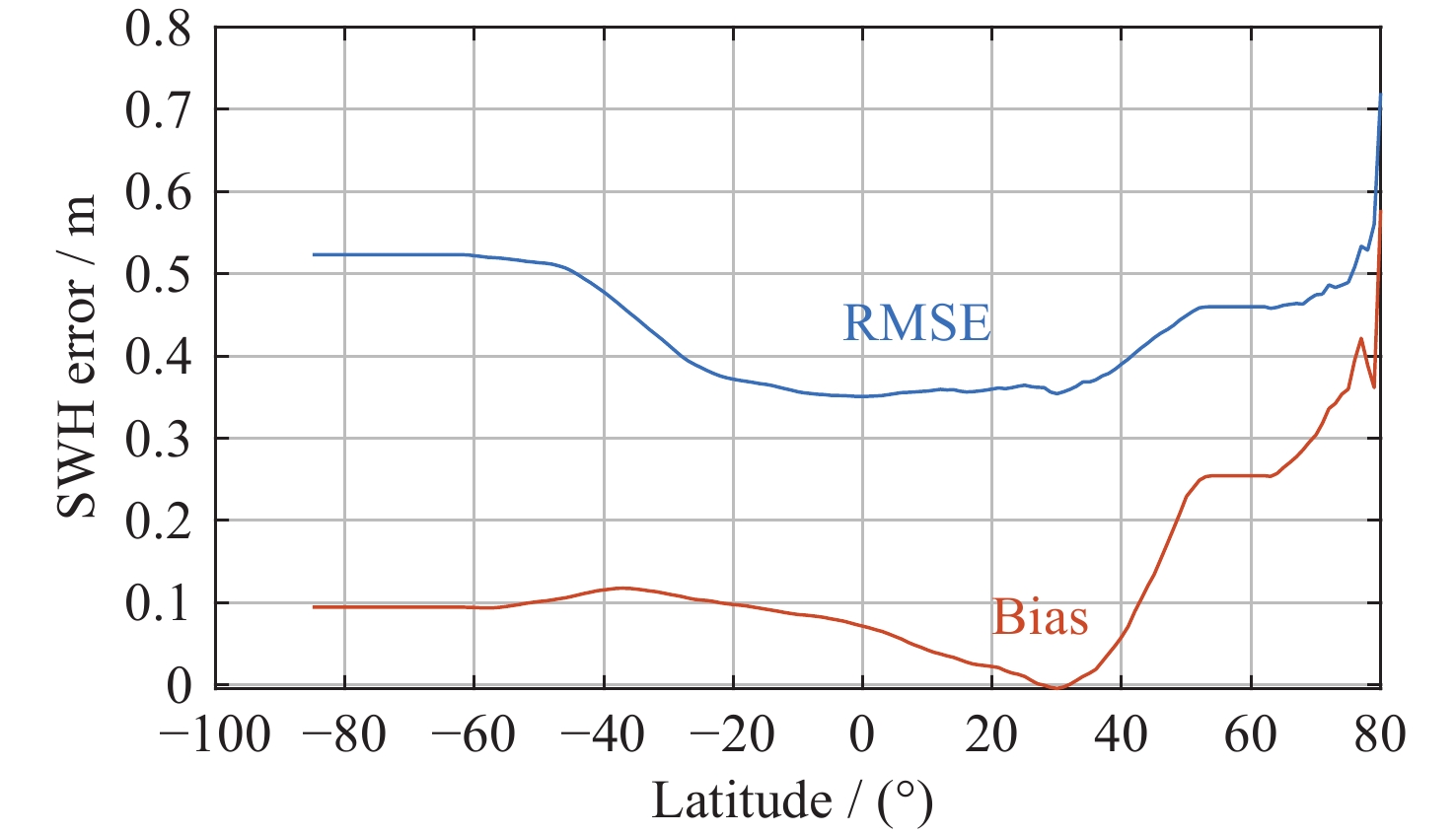
图 12 GNSS-R有效波高反演精度与数据纬度的关系
Figure 12. GNSS-R SWH retrieval statistics as a function of data latitudes
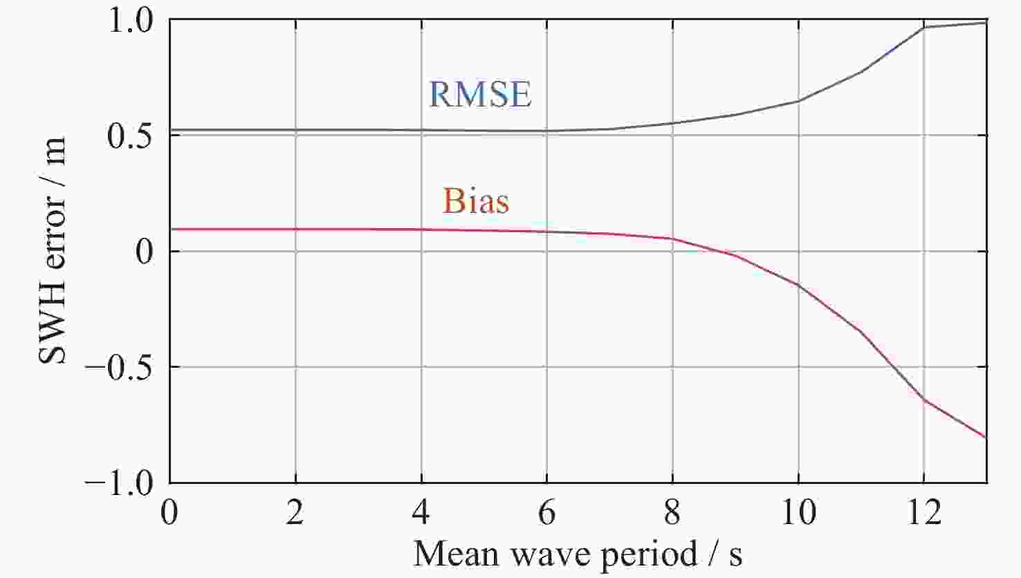
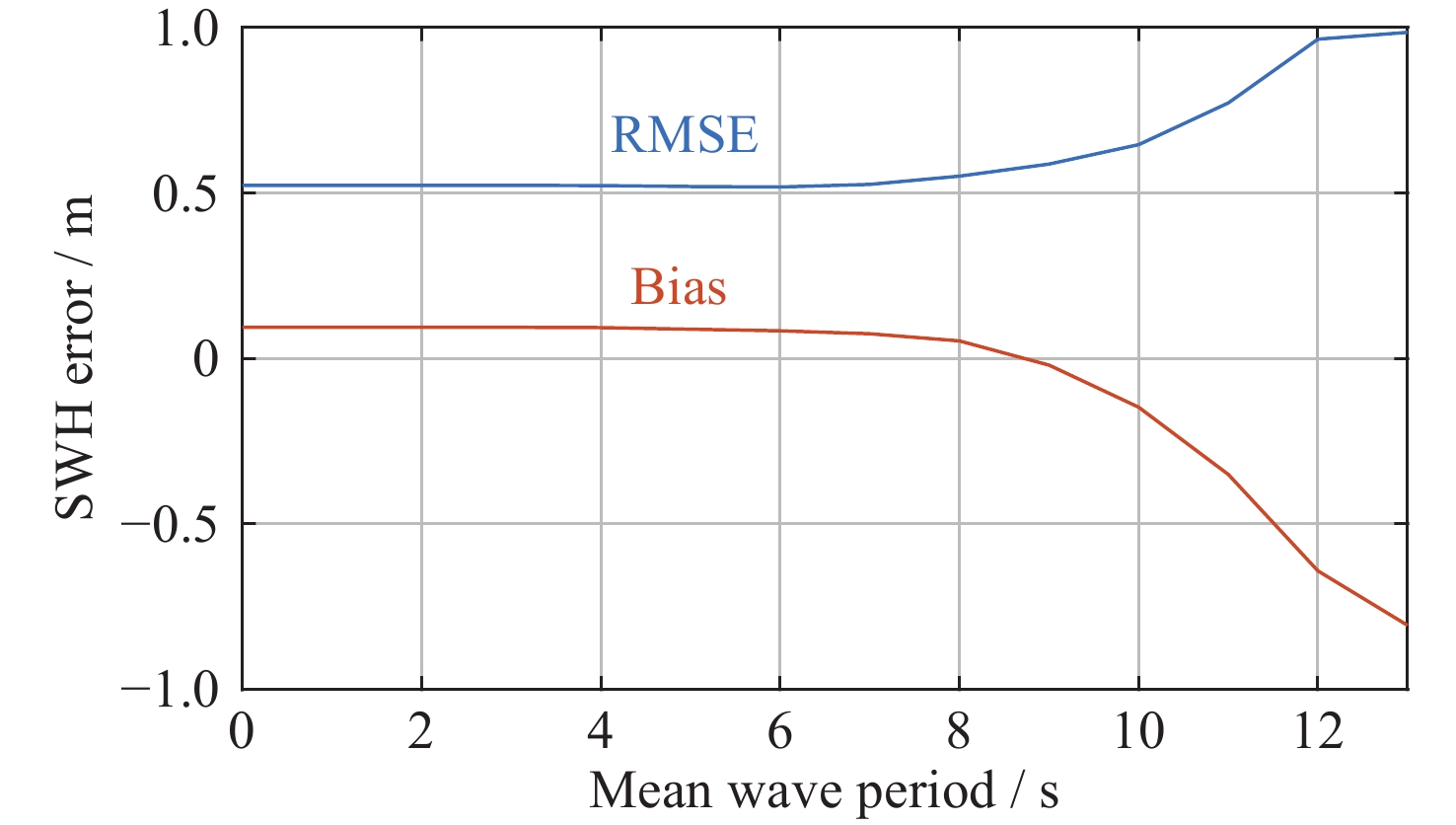
图 13 GNSS-R有效波高反演精度与海浪平均周期的关系
Figure 13. GNSS-R SWH retrieval statistics as a function of mean wave period
表 1 各种微波遥感技术在海洋遥感上的探测机理对比
Table 1. Comparison of mechanisms of different microwave ocean remote sensing techniques
探测技术 波段 主被动 探测机理 微波辐射计 C~Ka 被动 测量辐射亮温 散射计/SAR L~Ku 主动 后向布拉格散射 雷达高度计 Ku 主动 星下点镜面反射 GNSS-R L 主动 前向准镜面反射  下载: 导出CSV
表 2 各种微波遥感技术测量有效波高的卫星/载荷、反演精度、反演方法和对比数据源
Table 2. Satellite/payload, retrieval accuracy, methods, and comparison datasets from different microwave remote sensing technique in retrieving significant wave height
技术 卫星/载荷 精度/m 反演方法 对比数据源 参考文献 雷达高度计 Jason, Sentinel-3, HY-2 0.2~0.3 波形前沿斜率 浮标、高度计 [10–12,15] SAR Radasat, Sentinel-1等 0.3~0.5 先反演海浪谱, 再对海浪
谱积分或经验模型浮标、海浪模式 [13,14] 干涉成像高度计 天宫二号 0.3~0.5 与SAR相同 海浪模式、高度计 [15] 海浪波谱仪 CFOSAT/SWIM 0.3~0.4 波形前沿斜率 海浪模式、高度计 [16,17] 散射计 ERS-1/2, ASCAT等 0.5~0.72 雷达散射截面 浮标、海浪模式 [18,19]
下载: 导出CSV
表 3 不同特征参数、不同复杂度下的神经网络在训练集和测试集上的有效波高反演均方根误差 (单位: m)
Table 3. RMSE of neural network in retrieving SWH with different feature parameters and complexity (unit: m)
实验组 特征参数 网络 训练集精度 测试集精度 结果分析 1 NBRCS, LES, INC, AZI, PRN [25,25] 0.56 0.79 过拟合 2 同实验1 [10,10] 0.65 0.70 3 同实验1 [5,5] 0.68 0.69 4 实验1+SWS [25,25] 0.53 0.77 过拟合 5 实验1+SWS [10,10] 0.64 0.69 6 实验1+SWS [5,5] 0.67 0.68 7 实验1+SWS+Lat+Lon [25,25] 0.27 0.83 过拟合 8 实验1+SWS+Lat+Lon [10,10] 0.44 0.55 9 实验1+SWS+Lat+Lon [5,5] 0.46 0.52 10 实验1+SWS+Lat+Lon [3,3] 0.53 0.55 欠拟合 11 实验1 +Lat+Lon [5,5] 0.48 0.54 12 SWS+Lat+Lon [5,5] 0.53 0.58 13 Lat+Lon [5,5] 0.59 0.69
下载: 导出CSV
-
[1] ZAVOROTNY V U, GLEASON S, CARDELLACH E, et al. Tutorial on remote sensing using GNSS bistatic radar of opportunity[J]. IEEE Geoscience and Remote Sensing Magazine, 2014, 2(4): 8-45 doi: 10.1109/MGRS.2014.2374220 [2] MAYERS D R, RUF C S, WARNOCK A M. CYGNSS storm-centric tropical cyclone gridded wind speed product[J]. Journal of Applied Meteorology and Climatology, 2023, 62(3): 329-339 doi: 10.1175/JAMC-D-22-0054.1 [3] WARNOCK A M, RUF C S, RUSSEL A, et al. CYGNSS level 3 merged wind speed data product for storm force and surrounding environmental winds[J]. IEEE Journal of Selected Topics in Applied Earth Observations and Remote Sensing, 2024, 17: 6189-6200 doi: 10.1109/JSTARS.2024.3379934 [4] MUELLER M J, ANNANE B, LEIDNER S M, et al. Impact of CYGNSS-derived winds on tropical cyclone forecasts in a global and regional model[J]. Monthly Weather Review, 2021, 149(10): 3433-3447 doi: 10.1175/MWR-D-21-0094.1 [5] SUN Y Q, HUANG F X, XIA J M, et al. GNOS-II on Fengyun-3 satellite series: exploration of multi-GNSS reflection signals for operational applications[J]. Remote Sensing, 2023, 15(24): 5756 doi: 10.3390/rs15245756 [6] JALES P, CARTWRIGHT J, TALPE M, et al. Spire global’s operational GNSS-reflectometry constellation for earth surface observations[C]//Proceedings of 2023 IEEE International Geoscience and Remote Sensing Symposium. Pasadena: IEEE, 2023: 884-887 [7] HAUSER D, ABDALLA S, ARDHUIN F, et al. Satellite remote sensing of surface winds, waves, and currents: where are we now?[J]. Surveys in Geophysics, 2023, 44(5): 1357-1446 doi: 10.1007/s10712-023-09771-2 [8] AMANI M, GHORBANIAN A, ASGARIMEHR M, et al. Remote sensing systems for ocean: a review (Part 1: passive systems)[J]. IEEE Journal of Selected Topics in Applied Earth Observations and Remote Sensing, 2022, 15: 210-234 doi: 10.1109/JSTARS.2021.3130789 [9] AMANI M, MOHSENI F, LAYEGH N F, et al. Remote sensing systems for ocean: a review (Part 2: active systems)[J]. IEEE Journal of Selected Topics in Applied Earth Observations and Remote Sensing, 2022, 15: 1421-1453 doi: 10.1109/JSTARS.2022.3141980 [10] QUEFFEULOU P. Long-term validation of wave height measurements from altimeters[J]. Marine Geodesy, 2004, 27(3/4): 495-510 [11] JIA Y J, YANG J G, LIN M S, et al. Global assessments of the HY-2B measurements and cross-calibrations with Jason-3[J]. Remote Sensing, 2020, 12(15): 2470 doi: 10.3390/rs12152470 [12] 贾永君, 张有广, 林明森. HY-2卫星雷达高度计风速反演验证[J]. 中国工程科学, 2014, 16(6): 54-59JIA Yongjun, ZHANG Youguang, LIN Mingsen. Verification of HY-2 satellite radar altimeter wind retrieval[J]. Strategic Study of CAE, 2014, 16(6): 54-59 [13] STOPA J E, MOUCHE A. Significant wave heights from Sentinel‐1 SAR: validation and applications[J]. Journal of Geophysical Research: Oceans, 2017, 122(3): 1827-1848 doi: 10.1002/2016JC012364 [14] QUACH B, GLASER Y, STOPA J E, et al. Deep learning for predicting significant wave height from synthetic aperture radar[J]. IEEE Transactions on Geoscience and Remote Sensing, 2021, 59(3): 1859-1867 doi: 10.1109/TGRS.2020.3003839 [15] REN L, YANG J S, DONG X, et al. Preliminary significant wave height retrieval from interferometric imaging radar altimeter aboard the Chinese Tiangong-2 space laboratory[J]. Remote Sensing, 2021, 13(12): 2413 doi: 10.3390/rs13122413 [16] YE J, WAN Y, DAI Y S. Quality evaluation and calibration of the SWIM significant wave height product with buoy data[J]. Acta Oceanologica Sinica, 2021, 40(10): 187-196 doi: 10.1007/s13131-021-1835-x [17] HAUSER D, TOURAIN C, HERMOZO L, et al. New observations from the SWIM radar on-board CFOSAT: instrument validation and ocean wave measurement assessment[J]. IEEE Transactions on Geoscience and Remote Sensing, 2021, 59(1): 5-26 doi: 10.1109/TGRS.2020.2994372 [18] GUO J, HE Y J, PERRIE W, et al. A new model to estimate significant wave heights with ERS-1/2 scatterometer data[J]. Chinese Journal of Oceanology and Limnology, 2009, 27(1): 112-116 doi: 10.1007/s00343-009-0112-1 [19] WANG H, YANG J S, ZHU J H, et al. Estimation of significant wave heights from ASCAT scatterometer data via deep learning network[J]. Remote Sensing, 2021, 13(2): 195 doi: 10.3390/rs13020195 [20] WANG J K, AOUF L, DALPHINET A, et al. The wide swath significant wave height: an innovative reconstruction of significant wave heights from CFOSAT’s SWIM and scatterometer using deep learning[J]. Geophysical Research Letters, 2021, 48(6): e2020GL091276 doi: 10.1029/2020GL091276 [21] BU J W, YU K G. Significant wave height retrieval method based on spaceborne GNSS reflectometry[J]. IEEE Geoscience and Remote Sensing Letters, 2022, 19: 1503705 [22] WANG C Y, YU K G, ZHANG K F, et al. Significant wave height retrieval based on multivariable regression models developed with CYGNSS data[J]. IEEE Transactions on Geoscience and Remote Sensing, 2023, 61: 4200415 [23] WANG F, YANG D K, YANG L. Retrieval and assessment of significant wave height from CYGNSS mission using neural network[J]. Remote Sensing, 2022, 14(15): 3666 doi: 10.3390/rs14153666 [24] GÓMEZ-ENRI J, VIGNUDELLI S, QUARTLY G, et al. Bringing satellite radar altimetry closer to shore[C]//Proceedings of SPIE, Society of Photo-Optical Instrumentation Engineers. SPIE, 2009: 1-3 [25] ROSMORDUC V, BENVENISTE J, BRONNER E, et al. Radar altimetry tutorial[G/OL]. http://www.altimetry.info, 2011: 112-128 [26] HUANG F X, GARRISON J L, LEIDNER S M, et al. A forward model for data assimilation of GNSS ocean reflectometry delay-doppler maps[J]. IEEE Transactions on Geoscience and Remote Sensing, 2021, 59(3): 2643-2656 doi: 10.1109/TGRS.2020.3002801 [27] ZAVOROTNY V U, VORONOVICH A G. Scattering of GPS signals from the ocean with wind remote sensing application[J]. IEEE Transactions on Geoscience and Remote Sensing, 2000, 38(2): 951-964 doi: 10.1109/36.841977 [28] CHEN‐ZHANG D D, RUF C S, ARDHUIN F, et al. GNSS‐R nonlocal sea state dependencies: model and empirical verification[J]. Journal of Geophysical Research: Oceans, 2016, 121(11): 8379-8394 doi: 10.1002/2016JC012308 [29] SEMEDO A, SUŠELJ K, RUTGERSSON A, et al. A global view on the wind sea and swell climate and variability from ERA-40[J]. Journal of Climate, 2011, 24(5): 1461-1479 doi: 10.1175/2010JCLI3718.1 [30] LIN W M, PORTABELLA M, FOTI G, et al. Toward the generation of a wind geophysical model function for spaceborne GNSS-R[J]. IEEE Transactions on Geoscience and Remote Sensing, 2019, 57(2): 655-666 doi: 10.1109/TGRS.2018.2859191 -
-

 下载:
下载:


计量
- 文章访问数: 1488
- HTML全文浏览量: 501
- PDF下载量: 171
-
被引次数:
0(来源:Crossref)
0(来源:其他)

