


微波遥感与红外高光谱遥感联合应用的进展与展望
doi: 10.11728/cjss2025.02.2024-0195 cstr: 32142.14.cjss.2024-0195
-
 李旌阳 女, 现为中国科学院国家空间科学中心助理工程师, 主要从事红外与微波遥感融合技术及精细谱微波遥感分析研究. E-mail: lijingyang@mirslab.cn
 -
 何杰颖 女, 现为中国科学院国家空间科学中心研究员, 风云三号卫星微波湿度计与海洋卫星盐度辐射计副主任设计师、空间科学(二期)预先研究项目负责人, 主要从事星载微波辐射计设计与研制、定标技术及地球与行星探测定量反演研究. E-mail: hejieying@mirslab.cn
作者简介:
通讯作者:
Progress and Prospects of the Combined Application of Microwave Remote Sensing and Infrared Hyperspectral Remote Sensing
-
摘要: 随着地球科学研究的深入, 单一遥感技术由于物理机制的限制, 难以满足复杂地球系统观测对精度、时空分辨率和数据维度的需求. 本研究对微波遥感与红外高光谱遥感的结合应用进行综述, 通过分析相关文献, 探讨了两种技术的基础原理与特性, 总结其在灾害管理和生态环境监测中的应用现状, 梳理多传感器融合的技术进展, 并分析其面临的主要挑战, 包括时空分辨率差异、多传感器校准与数据处理复杂性等问题. 研究表明, 微波与红外高光谱遥感的融合能够提升观测精度与数据覆盖范围, 为气象预报、灾害响应和生态保护提供科学支持. 未来需优化融合算法与数据处理技术, 推动融合技术向产品化和实际应用转化, 为全球气候变化与生态环境研究提供更强有力的工具.Abstract: With the advancement of Earth science research, single remote sensing technologies face limitations in meeting the demands for accuracy, spatiotemporal resolution, and data dimensions in complex Earth system observations. This study reviews the combined application of microwave and infrared hyperspectral remote sensing. Through literature analysis, the fundamental principles and characteristics of both technologies are explored, their applications in disaster management and ecological environment monitoring are summarized, and the progress and challenges of multi-sensor data fusion are examined. Challenges include spatiotemporal resolution mismatches, multi-sensor calibration, and data processing complexities. The findings demonstrate that integrating microwave and infrared hyperspectral remote sensing can improve observation accuracy and data coverage, supporting weather forecasting, disaster response, and ecological protection. Future work should focus on optimizing fusion algorithms and data processing techniques to transition from theoretical research to practical applications, providing robust tools for global climate change and environmental studies.
-
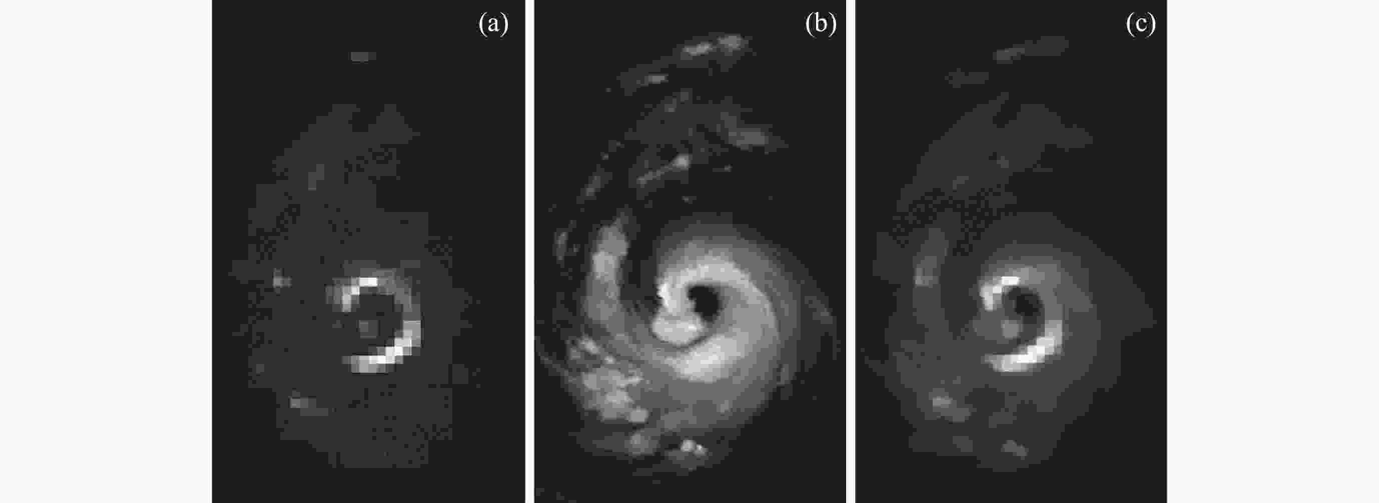
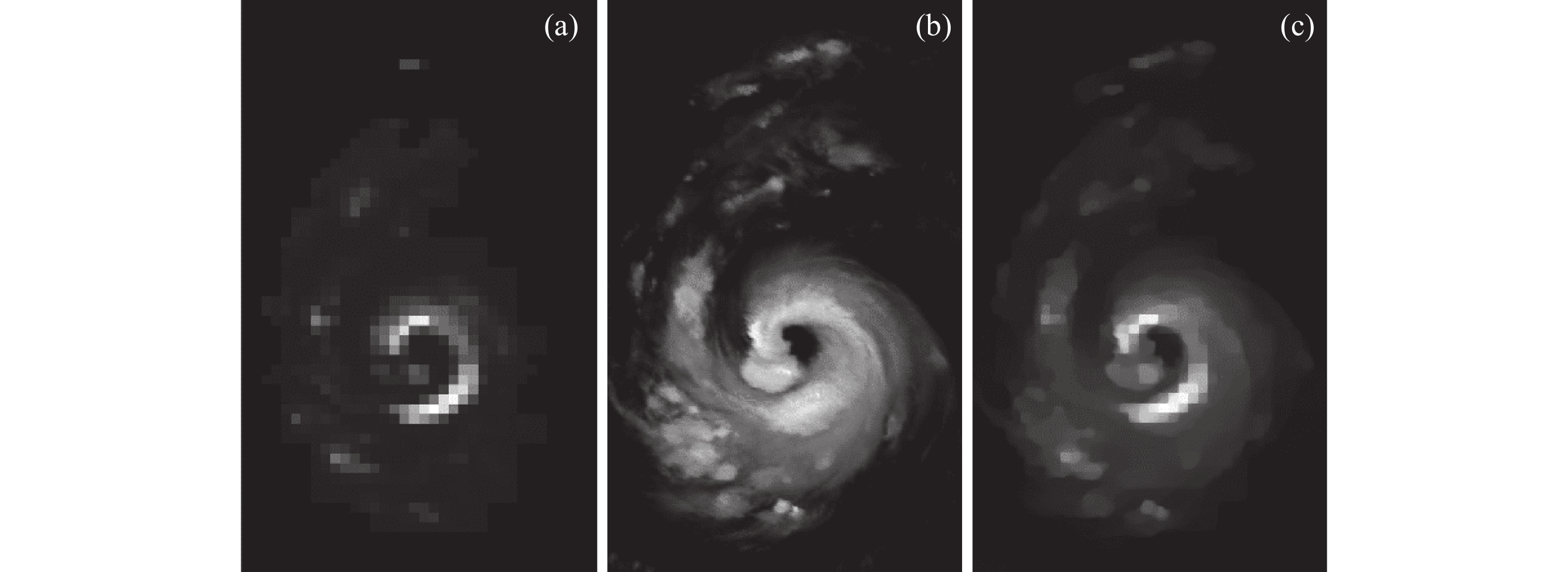
图 1 (a) 15 km 分辨率微波仪器Advanced Microwaved Sounding Unit-B (AMSU-B)图像, (b) 1.9 km分辨率红外高光谱仪器Advanced Very High Resolution Radiometer (AVHRR)图像, (c)数据融合结果
Figure 1. (a) AMSU-B image with 15 km resolution, (b) AVHRR image with 1.9 km resolution, (c) data fusion result with 1.9 km resolution
表 1 代表性微波载荷参数
Table 1. Specifications of representative microwave instruments
参数 MWHS-II ATMS 频率范围/GHz 89~183 23.8~183 通道数 15 22 空间分辨率/km 15 (166, 183 GHz)
30 (89, 118 GHz)16 (165~183 GHz)
32 (50 ~ 90 GHz)
75 (23~32 GHz) 下载: 导出CSV
表 2 代表性红外高光谱载荷参数
Table 2. Specifications of representative infrared hyperspectral instruments
参数 HIIRS-II AHSI LWIR MWIR SWIR VNIR SWIR 波长范围/μm 15.41~8.55 8.56~5.20 5.21~3.92 0.4~1.0 1.0~2.5 通道数 834 1207 1012 150 180 空间分辨率 14 km 30 m
下载: 导出CSV
-
[1] WULDER M A, LOVELAND T R, ROY D P, et al. Current status of Landsat program, science, and applications[J]. Remote Sensing of Environment, 2019, 225: 127-147 doi: 10.1016/j.rse.2019.02.015 [2] GORELICK N, HANCHER M, DIXON M, et al. Google Earth Engine: Planetary-scale geospatial analysis for everyone[J]. Remote Sensing of Environment, 2017, 202: 18-27 doi: 10.1016/j.rse.2017.06.031 [3] 李树涛, 李聪妤, 康旭东. 多源遥感图像融合发展现状与未来展望[J]. 遥感学报, 2021, 25(1): 148-166 doi: 10.11834/jrs.20210259LI Shutao, LI Congyu, KANG Xudong. Development status and future prospects of multi-source remote sensing image fusion[J]. National Remote Sensing Bulletin, 2021, 25(1): 148-166 doi: 10.11834/jrs.20210259 [4] SHEN H F, MENG X C, ZHANG L P. An integrated framework for the spatio–temporal–spectral fusion of remote sensing images[J]. IEEE Transactions on Geoscience and Remote Sensing, 2016, 54(12): 7135-7148 doi: 10.1109/TGRS.2016.2596290 [5] FAUVEL M, TARABALKA Y, BENEDIKTSSON J A, et al. Advances in spectral-spatial classification of hyperspectral images[J]. Proceedings of the IEEE, 2013, 101(3): 652-675 doi: 10.1109/JPROC.2012.2197589 [6] SISHODIA R P, RAY R L, SINGH S K. Applications of remote sensing in precision agriculture: a review[J]. Remote Sensing, 2020, 12(19): 3136 doi: 10.3390/rs12193136 [7] KE T, ZHONG Y F, SONG M, et al. Mineral detection based on hyperspectral remote sensing imagery on Mars: From detection methods to fine mapping[J]. ISPRS Journal of Photogrammetry and Remote Sensing, 2024, 218: 761-780 doi: 10.1016/j.isprsjprs.2024.09.020 [8] TSANG L, KONG J A, SHIN R T. Theory of Microwave Remote Sensing[M]. New York: Wiley-Interscience, 1985 [9] PAMPALONI P, PALOSCIA S. Microwave Radiometry and Remote Sensing of the Earth’s Surface and Atmosphere[M]. London: CRC Press, 2000 [10] GUIRAUD F O, HOWARD J, HOGG D C. A dual-channel microwave radiometer for measurement of precipitable water vapor and liquid[J]. IEEE Transactions on Geoscience Electronics, 1979, 17(4): 129-136 doi: 10.1109/TGE.1979.294639 [11] LIN M S, JIA Y J. Past, present and future marine microwave satellite missions in China[J]. Remote Sensing, 2022, 14(6): 1330 doi: 10.3390/rs14061330 [12] PU R L. Hyperspectral Remote Sensing: Fundamentals and Practices[M]. Boca Raton: CRC Press, 2017 [13] SABINS F F JR, ELLIS J M. Remote Sensing: Principles, Interpretation, and Applications[M]. 4th ed. Long Grove: Waveland Press, 2020 [14] 何杰颖, 张升伟, 王振占, 等. 风云气象卫星微波大气探测回顾与展望[J]. 空间科学学报, 2023, 43(6): 1025-1035 doi: 10.11728/cjss2023.06.yg16HE Jieying, ZHANG Shengwei, WANG Zhenzhan, et al. Prospects for microwave atmospheric sounding of the new generation of Fengyun meteorological satellites[J]. Chinese Journal of Space Science, 2023, 43(6): 1025-1035 doi: 10.11728/cjss2023.06.yg16 [15] WANG Z, WENG F Z, HAN Y, et al. Evaluations of microwave sounding instruments onboard FY-3F satellites for tropical cyclone monitoring[J]. Remote Sensing, 2024, 16(23): 4546 doi: 10.3390/rs16234546 [16] XIAO H Y, HAN W, ZHANG P, et al. Assimilation of data from the MWHS-II onboard the first early morning satellite FY-3E into the CMA global 4D-Var system[J]. Meteorological Applications, 2023, 30(3): e2133 doi: 10.1002/met.2133 [17] 刘银年, 孙德新, 胡晓宁, 等. 高分五号可见短波红外高光谱相机设计与研制[J]. 遥感学报, 2020, 24(4): 333-344LIU Yinnian, SUN Dexin, HU Xiaoning, et al. Development of visible and short-wave infrared hyperspectral imager onboard GF-5 satellite[J]. Journal of Remote Sensing (Chinese), 2020, 24(4): 333-344 [18] WENG F, ZOU X, WANG X, et al. Introduction to Suomi national polar-orbiting partnership advanced technology microwave sounder for numerical weather prediction and tropical cyclone applications[J]. Journal of Geophysical Research: Atmospheres, 2012, 117(D19): D19112 [19] WAGNER W, BLÖSCHL G, PAMPALONI P, et al. Operational readiness of microwave remote sensing of soil moisture for hydrologic applications[J]. Hydrology Research, 2007, 38(1): 1-20 doi: 10.2166/nh.2007.029 [20] SRIVASTAVA P K, O’NEILL P, COSH M, et al. Evaluation of dielectric mixing models for passive microwave soil moisture retrieval using data from ComRAD ground-based SMAP simulator[J]. IEEE Journal of Selected Topics in Applied Earth Observations and Remote Sensing, 2015, 8(9): 4345-4354 doi: 10.1109/JSTARS.2014.2372031 [21] YANOVSKY I, BEHRANGI A, WEN Y X, et al. Enhanced resolution of microwave sounder imagery through fusion with infrared sensor data[J]. Remote Sensing, 2017, 9(11): 1097 doi: 10.3390/rs9111097 [22] 谢振超, 徐红新, 安大伟, 等. 微波辐射计静止轨道遥感试验技术[J]. 上海航天, 2018, 35(2): 49-59XIE Zhenchao, XU Hongxin, AN Dawei, et al. Remote sensing technology of experimental microwave radiometer in geostationary orbit[J]. Aerospace Shanghai, 2018, 35(2): 49-59 [23] 杨何群, 王晓峰, 高彦青, 等. 数值天气预报对卫星大数据的需求分析[J]. 大数据, 2022, 8(2): 89-102 doi: 10.11959/j.issn.2096-0271.2022017YANG Hequn, WANG Xiaofeng, GAO Yanqing, et al. Analysis of satellite big data requirements in numerical weather prediction[J]. Big Data Research, 2022, 8(2): 89-102 doi: 10.11959/j.issn.2096-0271.2022017 [24] MADDY E S, BOUKABARA S A. MIIDAPS-AI: An explainable machine-learning algorithm for infrared and microwave remote sensing and data assimilation preprocessing - Application to LEO and GEO sensors[J]. IEEE Journal of Selected Topics in Applied Earth Observations and Remote Sensing, 2021, 14: 8566-8576 doi: 10.1109/JSTARS.2021.3104389 [25] KAZUMORI M. Assimilation experiments of microwave and infrared radiance data in JMA global numrical weather prediction system[C]//IGARSS 2019 - 2019 IEEE International Geoscience and Remote Sensing Symposium. Yokohama, Japan: IEEE, 2019: 4738-4740 [26] WANG W W, SHI C, SHANG H Z, et al. Development of an algorithm for the simultaneous retrieval of cloud-top height and cloud optical thickness combining radiative transfer and multisource satellite information from O4 hyperspectral measurements[J]. IEEE Transactions on Geoscience and Remote Sensing, 2024, 62: 4104111 [27] KIDD C, KNIVETON D R, TODD M C, et al. Satellite rainfall estimation using combined passive microwave and infrared algorithms[J]. Journal of Hydrometeorology, 2003, 4(6): 1088-1104 doi: 10.1175/1525-7541(2003)004<1088:SREUCP>2.0.CO;2 [28] WANG C G, TANG G Q, GENTINE P. PrecipGAN: Merging microwave and infrared data for satellite precipitation estimation using generative adversarial network[J]. Geophysical Research Letters, 2021, 48(5): e2020GL092032 doi: 10.1029/2020GL092032 [29] UPADHYAYA S A, KIRSTETTER P E, GOURLEY J J, et al. On the propagation of satellite precipitation estimation errors: from passive microwave to infrared estimates[J]. Journal of Hydrometeorology, 2020, 21(6): 1367-1381 doi: 10.1175/JHM-D-19-0293.1 [30] LI S, JIANG N, XU T H, et al. Tightly coupled tomography model for atmospheric water vapor based on multisource remote-sensing and GNSS data[J]. IEEE Transactions on Geoscience and Remote Sensing, 2024, 62: 5800816 [31] SONG T, YANG K L, LI X, et al. Probabilistic estimation of tropical cyclone intensity based on multi-source satellite remote sensing images[J]. Remote Sensing, 2024, 16(4): 606 doi: 10.3390/rs16040606 [32] 覃丹宇, 方宗义. 利用静止气象卫星监测初生对流的研究进展[J]. 气象, 2014, 40(1): 7-17 doi: 10.7519/j.issn.1000-0526.2014.01.002QIN Danyu, FANG Zongyi. Research progress of geostationary satellite-based convective initiation[J]. Meteorological Monthly, 2014, 40(1): 7-17 doi: 10.7519/j.issn.1000-0526.2014.01.002 [33] 崔新艳, 陈明轩, 秦睿, 等. 对流初生机理的研究进展[J]. 气象, 2021, 47(11): 1297-1318 doi: 10.7519/j.issn.1000-0526.2021.11.001CUI Xinyan, CHEN Mingxuan, QIN Rui, et al. Research advances in the convective initiation mechanisms[J]. Meteorological Monthly, 2021, 47(11): 1297-1318 doi: 10.7519/j.issn.1000-0526.2021.11.001 [34] 马鹏辉, 杨燕军, 张剑. 基于卫星云图的对流初生预测技术综述[J]. 气象与减灾研究, 2014, 37(1): 1-5MA Penghui, YANG Yanjun, ZHANG Jian. Research summary of convective initiation prediction based on meteorological satellite images[J]. Meteorology and Disaster Reduction Research, 2014, 37(1): 1-5 [35] 韦晓澄. 红外成像和微波探测在局地对流发生预警中的联合应用研究[D]. 北京: 中国气象科学研究院, 2021WEI Xiaocheng. Joint Application of Infrared Imaging and Microwave Detection in Early Warning of Local Convection[D]. Beijing: Chinese Academy of Meteorological Sciences, 2021 [36] LIU C Y, KUO S C, LIM A H N, et al. Optimal use of space-borne advanced infrared and microwave soundings for regional numerical weather prediction[J]. Remote Sensing, 2016, 8(10): 816 doi: 10.3390/rs8100816 [37] CHANZY A, BRUCKLER L, PERRIER A. Soil evaporation monitoring: a possible synergism of microwave and infrared remote sensing[J]. Journal of Hydrology, 1995, 165(1/2/3/4): 235-259 [38] ZHONG Y M, WEI Z S, MIAO L G, et al. Downscaling passive microwave soil moisture estimates using stand-alone optical remote sensing data[J]. IEEE Transactions on Geoscience and Remote Sensing, 2024, 62: 4504919 [39] LI Z L, TANG B H, WU H, et al. Satellite-derived land surface temperature: current status and perspectives[J]. Remote Sensing of Environment, 2013, 131: 14-37 doi: 10.1016/j.rse.2012.12.008 [40] ZHANG X D, ZHOU J, GOTTSCHE F M, et al. A method based on temporal component decomposition for estimating 1-km all-weather land surface temperature by merging satellite thermal infrared and passive microwave observations[J]. IEEE Transactions on Geoscience and Remote Sensing, 2019, 57(7): 4670-4691 doi: 10.1109/TGRS.2019.2892417 [41] TANG W B, XUE D J, LONG Z Y, et al. Near-real-time estimation of 1-km all-weather land surface temperature by integrating satellite passive microwave and thermal infrared observations[J]. IEEE Geoscience and Remote Sensing Letters, 2022, 19: 7001305 [42] WANG Z D, GUO P, WAN H. Improved drought monitoring method based on multisource remote sensing data[C]//IGARSS 2020 – 2020 IEEE International Geoscience and Remote Sensing Symposium. Waikoloa, HI, USA: IEEE, 2020: 5282-5285 [43] 付浩阳. 基于光学及微波遥感技术的土地盐碱化监测及土壤水分盐分反演研究[D]. 长春: 吉林大学, 2020FU Haoyang. Salinization Monitoring and Soil Moisture and Salinity Retrieval based on Optical and Microwave Remote Sensing Technology[D]. Changchun: Jilin University, 2020 [44] ZHAO T J, SHI J C, HU T X, et al. High resolution freeze/thaw states detection using combination of passive microwave and thermal infrared observations[C]//IGARSS 2018 – 2018 IEEE International Geoscience and Remote Sensing Symposium. Valencia, Spain: IEEE, 2018: 8555-8558 [45] 吴立新, 毛文飞, 刘善军, 等. 岩石受力红外与微波辐射变化机理及地应力遥感关键问题[J]. 遥感学报, 2018, 22(S1): 146-161WU Lixin, MAO Wenfei, LIU Shanjun, et al. Mechanisms of altering infrared-microwave radiation from stressed rock and key issues on crust stress remote sensing[J]. Journal of Remote Sensing, 2018, 22(S1): 146-161 [46] GAO Y H, ZHANG M M, WANG J J, et al. Cross-scale mixing attention for multisource remote sensing data fusion and classification[J]. IEEE Transactions on Geoscience and Remote Sensing, 2023, 61: 5507815 [47] SHU T. Multi-sensor remote sensing image alignment based on fast algorithms[J]. Journal of Intelligent Systems, 2023, 32(1): 20220289 doi: 10.1515/jisys-2022-0289 [48] ZHANG J X. Multi-source remote sensing data fusion: Status and trends[J]. International Journal of Image and Data Fusion, 2010, 1(1): 5-24 doi: 10.1080/19479830903561035 [49] KHALEGHI B, KHAMIS A, KARRAY F O, et al. Multisensor data fusion: A review of the state-of-the-art[J]. Information Fusion, 2013, 14(1): 28-44 doi: 10.1016/j.inffus.2011.08.001 [50] LI J X, HONG D F, GAO L R, et al. Deep learning in multimodal remote sensing data fusion: A comprehensive review[J]. International Journal of Applied Earth Observation and Geoinformation, 2022, 112: 102926 doi: 10.1016/j.jag.2022.102926 [51] 苏远超, 许若晴, 高连如, 等. 基于深度学习的高光谱遥感图像混合像元分解研究综述[J]. 遥感学报, 2024, 28(1): 1-19 doi: 10.11834/jrs.20243165SU Yuanchao, XU Ruoqing, GAO Lianru, et al. Development of deep learning-based hyperspectral remote sensing image unmixing[J]. National Remote Sensing Bulletin, 2024, 28(1): 1-19 doi: 10.11834/jrs.20243165 [52] BLACKWELL W J, BICKMEIER L J, LESLIE R V, et al. Hyperspectral microwave atmospheric sounding[J]. IEEE Transactions on Geoscience and Remote Sensing, 2011, 49(1): 128-142 doi: 10.1109/TGRS.2010.2052260 [53] 何杰颖, 张升伟, 张瑜. 微波大气温湿度精细探测[J]. 科技纵览, 2024(4): 76-77 doi: 10.3969/j.issn.2095-4409.2024.04.024HE Jieying, ZHANG Shengwei ZHANG Yu. Microwave-Based High-Resolution Atmospheric Temperature and Humidity Detection[J]. IEEE Spectrum, 2024(4): 76-77 doi: 10.3969/j.issn.2095-4409.2024.04.024 -
-

 下载:
下载:

计量
- 文章访问数: 914
- HTML全文浏览量: 442
- PDF下载量: 109
-
被引次数:
0(来源:Crossref)
0(来源:其他)

