


Retrieval methods for Tree Leaf Area Parameters Based on Terrestrial Laser Scanning
-
摘要: 叶面积指数(Leaf Area Index, LAI)是表征植被冠层结构的核心参数,叶面积指数的间接测量一直是植被遥感的一项重要研究内容。地基激光雷达(Terrestrial Laser Scanning, TLS)以其高效、精细的三维观测能力被广泛用于叶面积指数的反演研究,同时地基激光雷达也为反演更精细的叶面积参数,例如叶面积体密度(Foliage Area Volume Density, FAVD)的三维分布提供了可能性。从方法论角度出发,对基于地基激光雷达反演叶面积参数的主要方法,不同方法的优势、局限性和影响因素进行分析。现有反演方法可分为四类:基于间隙率的方法、基于接触频率的方法、基于计算机图形学理论的方法以及基于生态生理学模型的方法。基于地基激光雷达的叶面积参数反演也从样方尺度叶面积指数向更精细的单木尺度叶面积垂直剖面(Vertical Foliage Profile, VFP)和体素尺度叶面积体密度发展。在此过程中,聚集效应、非均一路径长度和遮挡效应是影响测量精度的重要因素,需要进一步的研究和校正。Abstract: Leaf Area Index (LAI) is a key parameter that characterizes the structure of vegetation canopies, and the indirect measurement of LAI has always been an important research topic in vegetation remote sensing. Terrestrial Laser Scanning (TLS), with its efficient and precise three-dimensional observation capability, has been widely used for LAI estimation. At the same time, TLS provides possibilities for the inversion of more refined leaf area parameters, such as the three-dimensional distribution of Foliage Area Volume Density (FAVD). This paper reviews the main methods for retrieving leaf area parameters based on TLS from a methodological perspective, discussing their advantages, limitations, and influencing factors. The indirect measurement of leaf area parameters based on TLS can be classified into four categories: the gap fraction-based method, the contact frequency-based method, the computer graphics theory-based method, and the ecophysiological model-based method. These methods differ in theoretical foundations, data organization, etc., and are suitable for the retrieval of various leaf area parameters at different scales. Among them, the mainstream approach currently relies on the measurement and analysis of gap fraction, and it has evolved into three categories based on different forms of point cloud organization: 2D images, pulses, and voxels. Methods based on contact frequency, computer graphics theory, and ecophysiological models are also emerging, providing new avenues for leaf area parameter inversion and can be further optimized to improve the accuracy and efficiency of LAI estimation. Existing methods have basically covered the inversion of various leaf area parameters at different scales. From stand-scale LAI to more refined individual-tree-scale Vertical Foliage Profile (VFP) and voxel-scale FAVD, leaf area parameter inversion based on TLS continues to advance in a refined and three-dimensional direction. In this process, clumping effects, non-uniform path lengths, and occlusion effects are important factors that affect measurement accuracy and require further research and calibration.
-
Key words:
- Leaf area parameter /
- Terrestrial laser scanning /
- Gap frequency /
- Contact frequency /
- Voxel
-
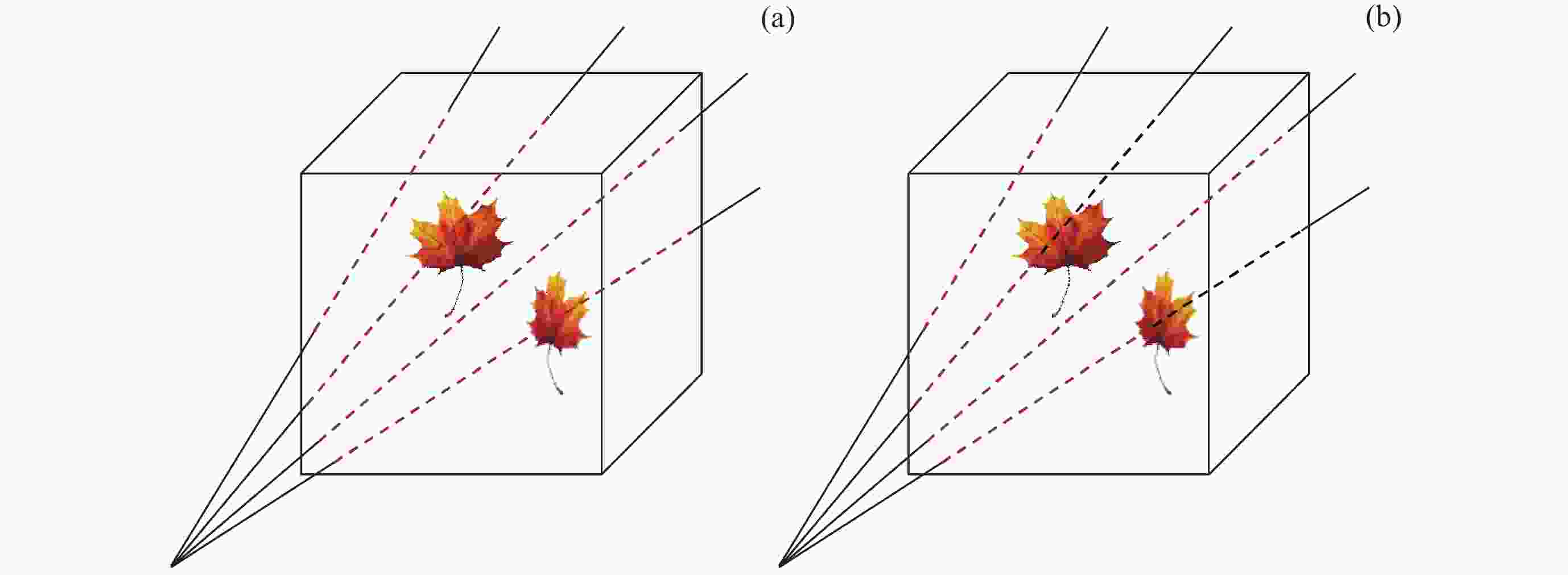
图 2 路径长度与自由路径长度。(a) 路径长度(红色虚线):不考虑命中植被元素条件下,光束通过体素的路径长度。(b) 自由路径长度(红色虚线):在最终命中植被元素之前光束实际探索的路径长度
Figure 2. Path length and free path length. (a) Path length (red dotted line): the length of the paths of beams through the voxels in case of absence of hit. (b) Free path length (red dotted line): the length of the paths actually explored by beams before eventual hit of vegetation element
表 1 不同的叶面积参数缩写及含义
Table 1. Abbreviations and meanings of different leaf area parameters
叶面积参数 缩写 含义 叶面积(Leaf Area) LA 所有叶片表面积的一半,常用于表征单木 叶面积指数(Leaf Area Index) LAI 单位水平地表面积上所有叶片表面积的一半 有效叶面积指数(Effective Leaf Area Index) LAIe 由Beer定律直接估算,未校正聚集效应的叶面积指数 真实叶面积指数(True Leaf Area Index) LAIc 由Beer定律估算并校正聚集效应的叶面积指数 叶面积体密度(Foliage Area Volume Density) FAVD 单位体积内单面叶面积总和,其在高度上的积分为叶面积指数 叶面积垂直剖面(Vertical Foliage Profile) VFP 以LAI或者FAVD表征冠层垂直方向上不同分层内叶面积差异  下载: 导出CSV
表 3 基于地基激光雷达的叶面积参数反演方法
Table 3. Leaf area parameter inversion methods based on TLS
理论机理 数据组织 方法概述 尺度 参数 代表文献 Beer定律 2D图像 经投影等操作转DHP图像 林分 LAIc [13, 33, 57, 59] 脉冲 点云切片计算RDI(Beer定律) 林分 LAIe [32, 61] 点云切片计算RDI(间隙大小分布法) 单木 LAIc [24–26] 构建树冠包络(路径长度分布模型) 单木 LA [14, 64] 体素 分层体素数量比计算间隙率(空/总) 单木 VFP [29] 体素内脉冲追踪 体素 FAVD [15, 27, 40] 斜点样方 体素 分层体素数量比计算接触频率(叶/总) 单木 VFP [79, 82] 体素内脉冲追踪(平均路径长度) 体素 FAVD [84] 体素内脉冲追踪(平均自由路径长度) 体素 FAVD [16, 86] 计算机图形学 点 特定点空间分辨率的代表面积 单木 LA [17] Delaunay三角网组织点云并计算面积 单木 LA [18] 生态生理学 点 构建异速生长回归方程 单木 LA [19]
下载: 导出CSV
表 4 联合多站数据方式及适用范围
Table 4. Approaches for joint multi-station data and their applicability
下载: 导出CSV
-
[1] CHEN J M, BLACK T A. Defining leaf area index for non-flat leaves[J]. Plant, Cell and Environment, 1992, 15(4): 421-429 doi: 10.1111/j.1365-3040.1992.tb00992.x [2] YAN G J, HU R H, LUO J H, et al. Review of indirect optical measurements of leaf area index: Recent advances, challenges, and perspectives[J]. Agricultural and Forest Meteorology, 2019, 265: 390-411 doi: 10.1016/j.agrformet.2018.11.033 [3] MAHOWALD N, LO F, ZHENG Y, et al. Projections of leaf area index in earth system models[J]. Earth System Dynamics, 2016, 7(1): 211-229 doi: 10.5194/esd-7-211-2016 [4] JUPP D L B, CULVENOR D S, LOVELL J L, et al. Estimating forest LAI profiles and structural parameters using a ground-based laser called Echidna[J]. Tree Physio logy, 2008, 29(2): 171-181 doi: 10.1093/treephys/tpn022 [5] 刘洋, 刘荣高, 陈镜明, 等. 叶面积指数遥感反演研究进展与展望[J]. 地球信息科学学报, 2013, 15(5): 734-743 doi: 10.3724/SP.J.1047.2013.00734LIU Yang, LIU Ronggao, CHEN Jingming, et al. Current status and perspectives of Leaf Area Index retrieval from optical remote sensing data[J]. Journal of Geo-Information Science, 2013, 15(5): 734-743 doi: 10.3724/SP.J.1047.2013.00734 [6] 王锦地, 李小文, STRAHLER A H. 树冠叶面积体密度和叶面积指数的间接估值方法研究[J]. 环境遥感, 1995, 10(4): 288-297WANG Jindi, LI Xiaowen, STRAHLER A H. An indirect estimating method of foliage area volume density and leaf-area index of tree crown[J]. Remote Sensing of Envi ronment China, 1995, 10(4): 288-297 [7] 骆社周, 王成, 张贵宾, 等. 机载激光雷达森林叶面积指数反演研究[J]. 地球物理学报, 2013, 56(5): 1467-1475 doi: 10.6038/cjg20130505LUO Shezhou, WANG Cheng, ZHANG Guibin, et al. Forest leaf area index (LAI) inversion using airborne LiDAR data[J]. Chinese Journal of Geophysics, 2013, 56(5): 1467-1475 doi: 10.6038/cjg20130505 [8] 徐希孺, 范闻捷, 陶欣. 遥感反演连续植被叶面积指数的空间尺度效应[J]. 中国科学 D辑: 中国科学, 2009, 39 (1): 79-87XU Xiru, FAN Wenjie, TAO Xin. The spatial scaling effect of continuous canopy Leaves Area Index retrieved by remote sensing[J]. Science in China Series D: Earth Sciences, 2009, 52 (3): 393-401 [9] BELAND M, PARKER G, SPARROW B, et al. On promoting the use of lidar systems in forest ecosystem research[J]. Forest Ecology and Management, 2019, 450: 117484 doi: 10.1016/j.foreco.2019.117484 [10] VAN LEEUWEN M, NIEUWENHUIS M. Retrieval of forest structural parameters using LiDAR remote sensing[J]. European Journal of Forest Research, 2010, 129(4): 749-770 doi: 10.1007/s10342-010-0381-4 [11] BAUWENS S, BARTHOLOMEUS H, CALDERS K, et al. Forest inventory with terrestrial LiDAR: a comparison of static and hand-held mobile laser scanning[J]. Forests, 2016, 7(6): 127 [12] NEWNHAM G, ARMSTON J, MUIR J, et al. Evaluation of Terrestrial Laser Scanners for Measuring Vegetation Structure[R]. Canberra: CSIRO, 2012 [13] ZHENG G, MOSKAL L M, KIM S H. Retrieval of effective leaf area index in heterogeneous forests with terrestrial laser scanning[J]. IEEE Transactions on Geoscience and Remote Sensing, 2013, 51(2): 777-786 doi: 10.1109/TGRS.2012.2205003 [14] HU R H, BOURNEZ E, CHENG S Y, et al. Estimating the leaf area of an individual tree in urban areas using terrestrial laser scanner and path length distribution model[J]. ISPRS Journal of Photogrammetry and Remote Sensing, 2018, 144: 357-368 doi: 10.1016/j.isprsjprs.2018.07.015 [15] NGUYEN V T, FOURNIER R A, CÔTÉ J F, et al. Estimation of vertical plant area density from single return terrestrial laser scanning point clouds acquired in forest environments[J]. Remote Sensing of Environment, 2022, 279: 113115 doi: 10.1016/j.rse.2022.113115 [16] BÉLAND M, WIDLOWSKI J L, FOURNIER R A, et al. Estimating leaf area distribution in savanna trees from terrestrial LiDAR measurements[J]. Agricultural and Forest Meteorology, 2011, 151(9): 1252-1266 doi: 10.1016/j.agrformet.2011.05.004 [17] MA L X, ZHENG G, EITEL J U H, et al. Determining woody-to-total area ratio using terrestrial laser scanning (TLS)[J]. Agricultural and Forest Meteorology, 2016, 228/229: 217-228 doi: 10.1016/j.agrformet.2016.06.021 [18] YUN T, CAO L, AN F, et al. Simulation of multi-platform LiDAR for assessing total leaf area in tree crowns[J]. Agricultural and Forest Meteorology, 2019, 276/277: 107610 doi: 10.1016/j.agrformet.2019.06.009 [19] OLSOY P J, MITCHELL J J, LEVIA D F, et al. Estimation of big sagebrush leaf area index with terrestrial laser scanning[J]. Ecological Indicators, 2016, 61: 815-821 doi: 10.1016/j.ecolind.2015.10.034 [20] 阎广建, 胡容海, 罗京辉, 等. 叶面积指数间接测量方法[J]. 遥感学报, 2016, 20(5): 958-978YAN Guangjian, HU Ronghai, LUO Jinghui, et al. Review of indirect methods for leaf area index measurement[J]. Journal of Remote Sensing, 2016, 20(5): 958-978 [21] WANG Y, FANG H L. Estimation of LAI with the LiDAR technology: a review[J]. Remote Sensing, 2020, 12(20): 3457 doi: 10.3390/rs12203457 [22] MUUMBE T P, BAADE J, SINGH J, et al. Terrestrial laser scanning for vegetation analyses with a special focus on savannas[J]. Remote Sensing, 2021, 13(3): 507 doi: 10.3390/rs13030507 [23] CIFUENTES R, VAN DER ZANDE D, FARIFTEH J, et al. Effects of voxel size and sampling setup on the estimation of forest canopy gap fraction from terrestrial laser scanning data[J]. Agricultural and Forest Meteorology, 2014, 194: 230-240 doi: 10.1016/j.agrformet.2014.04.013 [24] ZHU X, SKIDMORE A K, WANG T J, et al. Improving leaf area index (LAI) estimation by correcting for clumping and woody effects using terrestrial laser scanning[J]. Agricultural and Forest Meteorology, 2018, 263: 276-286 doi: 10.1016/j.agrformet.2018.08.026 [25] LI Y M, GUO Q H, SU Y J, et al. Retrieving the gap fraction, element clumping index, and leaf area index of individual trees using single-scan data from a terrestrial laser scanner[J]. ISPRS Journal of Photogrammetry and Remote Sensing, 2017, 130: 308-316 doi: 10.1016/j.isprsjprs.2017.06.006 [26] MOORTHY I, MILLER J R, BERNI J A J, et al. Field characterization of olive ( Olea europaea L. ) tree crown architecture using terrestrial laser scanning data[J]. Agricultural and Forest Meteorology, 2011, 151(2): 204-214 doi: 10.1016/j.agrformet.2010.10.005 [27] MKAOUAR A, KALLEL A, BEN RABAH Z, et al. Joint estimation of leaf area density and leaf angle distribution using TLS point cloud for forest stands[J]. IEEE Journal of Selected Topics in Applied Earth Observations and Remote Sensing, 2021, 14: 11095-11115 doi: 10.1109/JSTARS.2021.3120521 [28] WEI S S, YIN T G, DISSEGNA M A, et al. An assessment study of three indirect methods for estimating leaf area density and leaf area index of individual trees[J]. Agricultural and Forest Meteorology, 2020, 292/293: 108101 doi: 10.1016/j.agrformet.2020.108101 [29] ZHENG G, MOSKAL L M. Computational-geometry-based retrieval of effective leaf area index using terrestrial laser scanning[J]. IEEE Transactions on Geoscience and Remote Sensing, 2012, 50(10): 3958-3969 doi: 10.1109/TGRS.2012.2187907 [30] ZHAO K G, GARCÍA M, LIU S, et al. Terrestrial lidar remote sensing of forests: maximum likelihood estimates of canopy profile, leaf area index, and leaf angle distribution[J]. Agricultural and Forest Meteorology, 2015, 209/210: 100-113 doi: 10.1016/j.agrformet.2015.03.008 [31] YUN T, AN F, LI W Z, et al. A novel approach for retrieving tree leaf area from ground-based LiDAR[J]. Remote Sensing, 2016, 8(11): 942 doi: 10.3390/rs8110942 [32] PUESCHEL P, NEWNHAM G, HILL J. Retrieval of gap fraction and effective plant area index from phase-shift terrestrial laser scans[J]. Remote Sensing, 2014, 6(3): 2601-2627 doi: 10.3390/rs6032601 [33] GROTTI M, CALDERS K, ORIGO N, et al. An intensity, image-based method to estimate gap fraction, canopy openness and effective leaf area index from phase-shift terrestrial laser scanning[J]. Agricultural and Forest Meteorology, 2020, 280: 107766 doi: 10.1016/j.agrformet.2019.107766 [34] PASCU I S, DOBRE A C, BADEA O, et al. Estimating forest stand structure attributes from terrestrial laser scans[J]. Science of the Total Environment, 2019, 691: 205-215 doi: 10.1016/j.scitotenv.2019.06.536 [35] YANG X Y, STRAHLER A H, SCHAAF C B, et al. Three-dimensional forest reconstruction and structural parameter retrievals using a terrestrial full-waveform lidar instrument (Echidna®)[J]. Remote Sensing of Environment, 2013, 135: 36-51 doi: 10.1016/j.rse.2013.03.020 [36] ZHAO F, YANG X Y, SCHULL M A, et al. Measuring effective leaf area index, foliage profile, and stand height in New England forest stands using a full-waveform ground-based lidar[J]. Remote Sensing of Environment, 2011, 115(11): 2954-2964 doi: 10.1016/j.rse.2010.08.030 [37] HILKER T, VAN LEEUWEN M, COOPS N C, et al. Comparing canopy metrics derived from terrestrial and airborne laser scanning in a Douglas-fir dominated forest stand[J]. Trees, 2010, 24(5): 819-832 doi: 10.1007/s00468-010-0452-7 [38] STRAHLER A H, JUPP D L B, WOODCOCK C E, et al. Retrieval of forest structural parameters using a ground-based lidar instrument (Echidna®)[J]. Canadian Journal of Remote Sensing, 2008, 34(S2): S426-S440 [39] 郭庆华, 苏艳军, 胡天宇, 等. 激光雷达森林生态应用: 理论、方法及实例[M]. 北京: 高等教育出版社, 2018GUO Qinghua, SU Yanjun, HU Tianyu, et al. Lidar Principles, Processing and Applications in Forest Ecology[M]. Beijing: Higher Education Press, 2018 [40] GRAU E, DURRIEU S, FOURNIER R, et al. Estimation of 3D vegetation density with terrestrial laser scanning data using voxels. A sensitivity analysis of influencing parameters[J]. Remote Sensing of Environment, 2017, 191: 373-388 doi: 10.1016/j.rse.2017.01.032 [41] WANG Y, FANG H L, ZHANG Y H, et al. Retrieval and validation of vertical LAI profile derived from airborne and spaceborne LiDAR data at a deciduous needleleaf forest site[J]. GIScience & Remote Sensing, 2023, 60(1): 2214987 [42] DE WIT C T. Photosynthesis of Leaf Canopies[R]. Wageningen: Pudoc, 1965: 1-57 [43] MONSI M, SAEKI T. On the factor light in plant communities and its importance for matter production[J]. Annals of Botany, 2005, 95(3): 549-567 [44] ROSS J. The Radiation Regime and Architecture of Plant Stands[M]. Dordrecht: Springer, 1981 [45] NILSON T. A theoretical analysis of the frequency of gaps in plant stands[J]. Agricultural Meteorology, 1971, 8: 25-38 doi: 10.1016/0002-1571(71)90092-6 [46] WILSON J W. Inclined point quadrats[J]. New Phytologist, 1960, 59(1): 1-7 doi: 10.1111/j.1469-8137.1960.tb06195.x [47] YAN G J, JIANG H L, LUO J H, et al. Quantitative evaluation of leaf inclination angle distribution on leaf area index retrieval of coniferous canopies[J]. Journal of Remote Sensing, 2021, 2021: 2708904 [48] MILLER J B. A formula for average foliage density[J]. Australian Journal of Botany, 1967, 15(1): 141-144 doi: 10.1071/BT9670141 [49] 胡容海, 阎广建. 对Beer-Lambert定律间接测量森林LAI的误差低估分析[J]. 地球信息科学学报, 2012, 14(3): 366-375 doi: 10.3724/SP.J.1047.2012.00366HU Ronghai, YAN Guangjian. Indirect measurement of forest LAI to deal with the underestimation problem based on Beer-Lambert law[J]. Journal of Geo-Information Science, 2012, 14(3): 366-375 doi: 10.3724/SP.J.1047.2012.00366 [50] LANG A R G, XIANG Y Q. Estimation of leaf area index from transmission of direct sunlight in discontinuous canopies[J]. Agricultural and Forest Meteorology, 1986, 37(3): 229-243 doi: 10.1016/0168-1923(86)90033-X [51] CHEN J M, CIHLAR J. Plant canopy gap-size analysis theory for improving optical measurements of leaf-area index[J]. Applied Optics, 1995, 34(27): 6211-6222 doi: 10.1364/AO.34.006211 [52] LEBLANC S G, CHEN J M, FERNANDES R, et al. Methodology comparison for canopy structure parameters extraction from digital hemispherical photography in boreal forests[J]. Agricultural and Forest Meteorology, 2005, 129(3/4): 187-207 [53] WALTER J M N, FOURNIER R A, SOUDANI K, et al. Integrating clumping effects in forest canopy structure: an assessment through hemispherical photographs[J]. Canadian Journal of Remote Sensing, 2003, 29(3): 388-410 doi: 10.5589/m03-011 [54] HU R H, YAN G J, MU X H, et al. Indirect measurement of leaf area index on the basis of path length distribution[J]. Remote Sensing of Environment, 2014, 155: 239-247 doi: 10.1016/j.rse.2014.08.032 [55] HERBERT T J. Area projections of fisheye photographic lenses[J]. Agricultural and Forest Meteorology, 1987, 39(2/3): 215-223 [56] DANSON F M, HETHERINGTON D, MORSDORF F, et al. Forest canopy gap fraction from terrestrial laser scanning[J]. IEEE Geoscience and Remote Sensing Letters, 2007, 4(1): 157-160 doi: 10.1109/LGRS.2006.887064 [57] ZHENG G, MOSKAL L M. Spatial variability of terrestrial laser scanning based leaf area index[J]. International Journal of Applied Earth Observation and Geoinformation, 2012, 19: 226-237 doi: 10.1016/j.jag.2012.05.002 [58] SFU. Gap Light Analyzer (GLA)[M]. Burnaby: Simon Fraser University, 1999 [59] ARSLAN A E, ERTEN E, INAN M. A comparative study for obtaining effective Leaf Area Index from single Terrestrial Laser Scans by removal of wood material[J]. Measurement, 2021, 178: 109262 doi: 10.1016/j.measurement.2021.109262 [60] FLYNN W R M, OWEN H J F, GRIEVE S W D, et al. Quantifying vegetation indices using terrestrial laser scanning: methodological complexities and ecological insights from a Mediterranean forest[J]. Biogeosciences, 2023, 20(13): 2769-2784 doi: 10.5194/bg-20-2769-2023 [61] WOODGATE W, JONES S D, SUAREZ L, et al. Understanding the variability in ground-based methods for retrieving canopy openness, gap fraction, and leaf area index in diverse forest systems[J]. Agricultural and Forest Meteorology, 2015, 205: 83-95 doi: 10.1016/j.agrformet.2015.02.012 [62] MOORTHY I, MILLER J R, HU B X, et al. Retrieving crown leaf area index from an individual tree using ground-based lidar data[J]. Canadian Journal of Remote Sensing, 2008, 34(3): 320-332 doi: 10.5589/m08-027 [63] ANTONARAKIS A S, RICHARDS K S, BRASINGTON J, et al. Determining leaf area index and leafy tree roughness using terrestrial laser scanning[J]. Water Resources Research, 2010, 46(6): W06510 [64] CHEN Y M, ZHANG W M, HU R H, et al. Estimation of forest leaf area index using terrestrial laser scanning data and path length distribution model in open-canopy forests[J]. Agricultural and Forest Meteorology, 2018, 263: 323-333 doi: 10.1016/j.agrformet.2018.09.006 [65] BÉLAND M, WIDLOWSKI J L, FOURNIER R A. A model for deriving voxel-level tree leaf area density estimates from ground-based LiDAR[J]. Environmental Modelling & Software, 2014, 51: 184-189 [66] DURRIEU S, ALLOUIS T, FOURNIER R A, et al. Spatial quantification of vegetation density from terrestrial laser scanner data for characterization of 3D forest structure at plot level[C]//Proceedings of the SilviLaser 2008. Edinburgh: SilviLaser, 2008 [67] SOMA M, PIMONT F, DUPUY J L. Sensitivity of voxel-based estimations of leaf area density with terrestrial LiDAR to vegetation structure and sampling limitations: a simulation experiment[J]. Remote Sensing of Environment, 2021, 257: 112354 doi: 10.1016/j.rse.2021.112354 [68] SOMA M, PIMONT F, DURRIEU S, et al. Enhanced measurements of leaf area density with T-LiDAR: evaluating and calibrating the effects of vegetation heterogeneity and scanner properties[J]. Remote Sensing, 2018, 10(10): 1580 doi: 10.3390/rs10101580 [69] WU D, PHINN S, JOHANSEN K, et al. Estimating changes in leaf area, leaf area density, and vertical leaf area profile for mango, avocado, and macadamia tree crowns using terrestrial laser scanning[J]. Remote Sensing, 2018, 10(11): 1750 doi: 10.3390/rs10111750 [70] BÉLAND M, BALDOCCHI D D, WIDLOWSKI J L, et al. On seeing the wood from the leaves and the role of voxel size in determining leaf area distribution of forests with terrestrial LiDAR[J]. Agricultural and Forest Meteorology, 2014, 184: 82-97 doi: 10.1016/j.agrformet.2013.09.005 [71] SOMA M, PIMONT F, ALLARD D, et al. Mitigating occlusion effects in Leaf Area Density estimates from Terrestrial LiDAR through a specific kriging method[J]. Remote Sensing of Environment, 2020, 245: 111836 doi: 10.1016/j.rse.2020.111836 [72] CÔTÉ J F, FOURNIER R A, EGLI R. An architectural model of trees to estimate forest structural attributes using terrestrial LiDAR[J]. Environmental Modelling & Software, 2011, 26(6): 761-777 [73] HANCOCK S, ANDERSON K, DISNEY M, et al. Measurement of fine-spatial-resolution 3D vegetation structure with airborne waveform lidar: calibration and validation with voxelised terrestrial lidar[J]. Remote Sensing of Environment, 2017, 188: 37-50 doi: 10.1016/j.rse.2016.10.041 [74] HOSOI F, OMASA K. Factors contributing to accuracy in the estimation of the woody canopy leaf area density profile using 3D portable lidar imaging[J]. Journal of Experimental Botany, 2007, 58(12): 3463-3473 doi: 10.1093/jxb/erm203 [75] SCHNEIDER F D, KüKENBRINK D, SCHAEPMAN M E, et al. Quantifying 3D structure and occlusion in dense tropical and temperate forests using close-range LiDAR[J]. Agricultural and Forest Meteorology, 2019, 268: 249-257 doi: 10.1016/j.agrformet.2019.01.033 [76] TAHERIAZAD L, MOGHADAS H, SANCHEZ-AZOFEIFA A. Calculation of leaf area index in a Canadian boreal forest using adaptive voxelization and terrestrial LiDAR[J]. International Journal of Applied Earth Observation and Geoinformation, 2019, 83: 101923 doi: 10.1016/j.jag.2019.101923 [77] LEVY E B. The point method for pasture analysis[J]. N Z J Agric, 1933, 46: 267-279 [78] WILSON J W. Analysis of the spatial distribution of foliage by two-dimensional point quadrats[J]. New Phytologist, 1959, 58(1): 92-99 doi: 10.1111/j.1469-8137.1959.tb05340.x [79] HOSOI F, OMASA K. Voxel-based 3-D modeling of individual trees for estimating leaf area density using high-resolution portable scanning lidar[J]. IEEE Transactions on Geoscience and Remote Sensing, 2006, 44(12): 3610-3618 doi: 10.1109/TGRS.2006.881743 [80] HOSOI F, NAKAI Y, OMASA K. Estimation and error analysis of woody canopy leaf area density profiles using 3-D airborne and ground-based scanning lidar remote-sensing techniques[J]. IEEE Transactions on Geoscience and Remote Sensing, 2010, 48(5): 2215-2223 doi: 10.1109/TGRS.2009.2038372 [81] LI Y M, GUO Q H, TAO S L, et al. Derivation, validation, and sensitivity analysis of terrestrial laser scanning-based leaf area index[J]. Canadian Journal of Remote Sensing, 2016, 42(6): 719-729 doi: 10.1080/07038992.2016.1220829 [82] SU W, ZHU D H, HUANG J X, et al. Estimation of the vertical leaf area profile of corn ( Zea mays) plants using terrestrial laser scanning (TLS)[J]. Computers and Electronics in Agriculture, 2018, 150: 5-13 doi: 10.1016/j.compag.2018.03.037 [83] XIE X S, YANG Y Z, LI W Z, et al. Estimation of leaf area index in a typical northern tropical secondary monsoon rainforest by different indirect methods[J]. Remote Sensing, 2023, 15(6): 1621 doi: 10.3390/rs15061621 [84] BAILEY B N, MAHAFFEE W F. Rapid, high-resolution measurement of leaf area and leaf orientation using terrestrial LiDAR scanning data[J]. Measurement Science and Technology, 2017, 28(6): 064006 doi: 10.1088/1361-6501/aa5cfd [85] PIMONT F, ALLARD D, SOMA M, et al. Estimators and confidence intervals for plant area density at voxel scale with T-LiDAR[J]. Remote Sensing of Environment, 2018, 215: 343-370 doi: 10.1016/j.rse.2018.06.024 [86] BÉLAND M, KOBAYASHI H. Mapping forest leaf area density from multiview terrestrial lidar[J]. Methods in Ecology and Evolution, 2021, 12(4): 619-633 doi: 10.1111/2041-210X.13550 [87] YOU H K, LI S H, MA L X, et al. Leaf area index retrieval for broadleaf trees by envelope fitting method using terrestrial laser scanning data[J]. IEEE Geoscience and Remote Sensing Letters, 2022, 19: 1-5 [88] XU Y F, LI S H, YOU H K, et al. Retrieval of canopy gap fraction from terrestrial laser scanning data based on the monte carlo method[J]. IEEE Geoscience and Remote Sensing Letters, 2022, 19: 1-5 [89] WEISS M, BARET F, SMITH G J, et al. Review of methods for in situ Leaf Area Index (LAI) determination[J]. Agricultural and Forest Meteorology, 2004, 121(1/2): 37-53 [90] ROBERTS S D, DEAN T J, EVANS D L, et al. Estimating individual tree leaf area in loblolly pine plantations using LiDAR-derived measurements of height and crown dimensions[J]. Forest Ecology and Management, 2005, 213(1/2/3): 54-70 [91] FARID A, GOODRICH D C, BRYANT R, et al. Using airborne lidar to predict Leaf Area Index in cottonwood trees and refine riparian water-use estimates[J]. Journal of Arid Environments, 2008, 72(1): 1-15 doi: 10.1016/j.jaridenv.2007.04.010 [92] POPE G, TREITZ P. Leaf Area Index (LAI) estimation in boreal mixedwood forest of ontario, canada using Light Detection and Ranging (LiDAR) and WorldView-2 imagery[J]. Remote Sensing, 2013, 5(10): 5040-5063 doi: 10.3390/rs5105040 [93] QU Y H, SHAKER A, SILVA C A, et al. Remote sensing of leaf area index from LiDAR height percentile metrics and comparison with MODIS product in a selectively logged tropical forest area in eastern amazonia[J]. Remote Sensing, 2018, 10(6): 970 doi: 10.3390/rs10060970 [94] RICHARDSON J J, MOSKAL L M, KIM S H. Modeling approaches to estimate effective leaf area index from aerial discrete-return LIDAR[J]. Agricultural and Forest Meteorology, 2009, 149(6/7): 1152-1160 [95] LOVELL J L, JUPP D L B, CULVENOR D S, et al. Using airborne and ground-based ranging lidar to measure canopy structure in Australian forests[J]. Canadian Journal of Remote Sensing, 2003, 29(5): 607-622 doi: 10.5589/m03-026 [96] TAO S L, WU F F, GUO Q H, et al. Segmenting tree crowns from terrestrial and mobile LiDAR data by exploring ecological theories[J]. ISPRS Journal of Photogrammetry and Remote Sensing, 2015, 110: 66-76 doi: 10.1016/j.isprsjprs.2015.10.007 [97] LI W K, GUO Q H, JAKUBOWSKI M K, et al. A new method for segmenting individual trees from the lidar point cloud[J]. Photogrammetric Engineering & Remote Sensing, 2012, 78(1): 75-84 [98] FU H P, LI H, DONG Y Q, et al. Segmenting individual tree from TLS point clouds using improved DBSCAN[J]. Forests, 2022, 13(4): 566 doi: 10.3390/f13040566 [99] INDIRABAI I, NAIR M V H, JAISHANKER R N, et al. Terrestrial laser scanner based 3D reconstruction of trees and retrieval of leaf area index in a forest environment[J]. Ecological Informatics, 2019, 53: 100986 doi: 10.1016/j.ecoinf.2019.100986 [100] ROUZBEH KARGAR A, MACKENZIE R, ASNER G P, et al. A density-based approach for leaf area index assessment in a complex forest environment using a terrestrial laser scanner[J]. Remote Sensing, 2019, 11(15): 1791 doi: 10.3390/rs11151791 -
-

 下载:
下载:


计量
- 文章访问数: 1294
- HTML全文浏览量: 393
- PDF下载量: 85
-
被引次数:
0(来源:Crossref)
0(来源:其他)

