


Spatial Observation and Assessment of Sustainable Development Goals
-
摘要: 联合国《变革我们的世界:2030年可持续发展议程》已实施过半,国际社会广泛关切2030年议程前半程的有益经验和不利教训,并为后半程和未来可持续发展寻找指引和方向。及时、准确数据的缺失,仍然是制约人类应对长期、短期可持续发展问题的短板,更是阻碍可持续发展目标(Sustainable Development Goals, SDGs)进展监测、实施决策的瓶颈。作为全面、综合、整体研究地球系统的重要手段,空间观测技术是弥补当前SDGs指标统计数据不足、时空信息缺失的重要方法。本文介绍了空间观测技术在监测和评估SDG2零饥饿、SDG6清洁饮水和卫生设施、SDG7经济适用的清洁能源、SDG11可持续城市和社区、SDG13气候行动、SDG14水下生物和SDG 15陆地生物等7个可持续发展目标的研究进展及挑战,并对SDGs指标空间观测体系建设、空间观测数据共享和应用、SDGs监测评估方法研究等进行探讨。Abstract: Since 2015, the United Nations has reached the halfway point in implementing the 2030 agenda for sustainable development. During this period, progress on the Sustainable Development Goals (SDGs) faced challenges. In order to chart a course for future sustainable development, it’s essential for the worldwide community to learn from the experiences and lessons of the initial phase of the 2030 agenda, strengthening the implementation of the SDGs in the second phase. The lack of timely and accurate data remains a weak point in responding to both long and short-term issues and is a bottleneck in the implementation and monitoring of the SDGs and the development of science-based decision-making. Spatial observations, as a representative digital technology, can play an important role in bridging the gap between current statistical data and spatiotemporal information of the SDGs. This paper introduces important advances and existing issues in spatial observation techniques in the monitoring and evaluation of the seven sustainable development goals. Finally, the construction of SDGs spatial observation system, sharing and application of spatial observation data, and SDGs monitoring and evaluation methods are discussed.
-
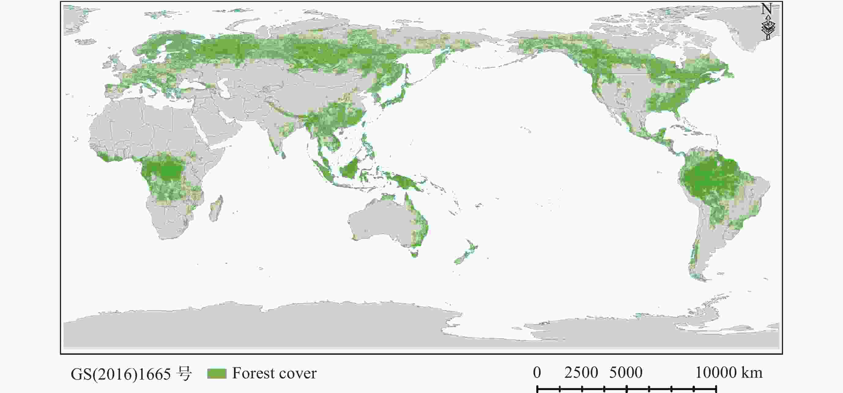
图 1 基于空间观测技术的全球森林覆盖分布
Figure 1. Global forests cover distribution based on spatial observation technology
-
[1] UN. Transforming Our World: the 2030 Agenda for Sustainable Development[R/OL]. (2015-10-21)[2023-08-20]. https://sdgs.un.org/2030agenda [2] UN. The Sustainable Development Goals Report 2022[R/OL]. (2022-07-12)[2022-08-22]. https://www.un.org/development/desa/dspd/2022/07/sdgs-report/ [3] SACHS J, LAFORTUNE G, KROLL C, et al. From Crisis to Sustainable Development: the SDGs as Roadmap to 2030 and Beyond. Sustainable Development Report 2022[R/OL]. (2022-06-02) [2023-08-22]. https://www.sdgindex.org/reports/sustainable-development-report-2022/ [4] UN. The Sustainable Development Goals Report 2023: Special Edition[R/OL]. (2023-07-10)[2023-08-20]. https://unstats.un.org/sdgs/report/2023/ [5] OECD. A Territorial Approach to the Sustainable Development Goals[R/OL]. (2020-02-07)[2022-08-22]. https://www.oecd.org/cfe/a-territorial-approach-to-the-sustainable-development-goals-e86fa715-en.htm [6] 施建成, 郭华东, 董晓龙, 等. 中国空间地球科学发展现状及未来策略[J]. 空间科学学报, 2021, 41(1): 95-117 doi: 10.11728/cjss2021.01.095SHI Jiancheng, GUO Huadong, DONG Xiaolong, et al. Developments and future strategies of Earth science from space in China[J]. Chinese Journal of Space Science, 2021, 41(1): 95-117 doi: 10.11728/cjss2021.01.095 [7] GUO H D, LIANG D, SUN Z C, et al. Measuring and evaluating SDG indicators with Big Earth Data[J]. Science Bulletin, 2022, 67(12): 1792-1801 [8] 郭华东, 梁栋, 陈方, 等. 地球大数据促进联合国可持续发展目标实现[J]. 中国科学院院刊, 2021, 36(8): 874-884 doi: 10.16418/j.issn.1000-3045.20210707006GUO Huadong, LIANG Dong, CHEN Fang, et al. Big earth data facilitates sustainable development goals[J]. Bulletin of Chinese Academy of Sciences, 2021, 36(8): 874-884 doi: 10.16418/j.issn.1000-3045.20210707006 [9] FAO. Tracking Progress on Food and Agriculture-Related SDG Indicators 2021: A Report on the Indicators under FAO Custodianship[R]. Rome: FAO, 2021. DOI: 10.4060/cb6872en [10] FAO, IFAD, UNICEF, et al. The State of Food Security and Nutrition in the World 2022. Repurposing Food and Agricultural Policies to Make Healthy Diets More Affordable[R]. Rome: FAO, IFAD, UNICEF, WFP, WHO, 2022. DOI: 10.4060/cc0639en [11] OECD, FAO. OECD-FAO Agricultural Outlook 2023-2032[OL]. (2022-07-06)[2023-08-22]. https://doi.org/10.1787/08801ab7-en [12] FAO. FAO and the SDGs. Indicators: Measuring Up to the 2030 Agenda for Sustainable Development[R]. Rome: FAO, 2017 [13] FAO. FAO Stat: FAOSTAT Online Statistical Service Food and Agriculture Organization[OL]. (2023-07-17)[2023-08-22]. https://www.fao.org/faostat/en/#home [14] GENNARI P, ROSERO-MONCAYO J, TUBIELLO F N. The FAO contribution to monitoring SDGs for food and agriculture[J]. Nature Plants, 2019, 5(12): 1196-1197 doi: 10.1038/s41477-019-0564-z [15] 桑一铭, 卢亚晗, 王学, 等. 青藏高原“一江两河”地区耕地分布数据集[J]. 全球变化数据学报, 2022, 6(4): 619-630SANG Yiming, LU Yahan, WANG Xue, et al. Farmland Distribution Dataset of the Yarlung Zangbo–Lhasa–Nyangqu River Region of the Tibetan Plateau[J]. Journal of Global Change Data & Discovery, 2022, 6(4): 619-630 [16] 申格, 刘航, 李丹丹, 等. 东北三省2020-2022年间10 m空间分辨率耕地资源空间分布数据集[J]. 农业大数据学报, 2023, 5(2): 2-8SHEN Ge, LIU Hang, LI Danan, et al. A 10 m spatial resolution dataset for the spatial distribution of cropland resources in the Three Northeastern Provinces from 2020 to 2022[J]. Journal of Agricultural Big Data, 2023, 5(2): 2-8 [17] LIU N, XING Z Z, ZHAO R M, et al. Analysis of chlorophyll concentration in potato crop by coupling continuous wavelet transform and spectral variable optimization[J]. Remote Sensing, 2020, 12(17): 2826 doi: 10.3390/rs12172826 [18] 王众娇, 魏茂盛, 郭凌峰, 等. 基于主成分分析的农作物空间分布信息提取[J]. 测绘与空间地理信息, 2021, 44(6): 114-115,119 doi: 10.3969/j.issn.1672-5867.2021.06.031WANG Zhongjiao, WEI Maosheng, GUO Lingfeng, et al. Extraction of crop spatial distribution information based onprincipal component analysis[J]. Geomatics & Spatial Information Technology, 2021, 44(6): 114-115,119 doi: 10.3969/j.issn.1672-5867.2021.06.031 [19] ROY D P, YAN L. Robust Landsat-based crop time series modelling[J]. Remote Sensing of Environment, 2018, 238: 110810 [20] 任鸿瑞, 张悦琦, 何奇瑾, 等. 基于FY-3 MERSI遥感数据的水稻种植分布提取[J]. 光谱学与光谱分析, 2023, 43(5): 1606-1611REN Hongrui, ZHANG Yueqi, HE Qijin, et al. Extraction of pddy rice planting area based on multi-temporal FY-3 MERSI remote sensing images[J]. Spectroscopy and Spectral Analysis, 2023, 43(5): 1606-1611 [21] 周佳玮, 涂理林, 陈洪建, 等. 融合空间和时序遥感信息的深度学习水稻提取[J]. 地理空间信息, 2022, 20(2): 39-44ZHOU Jiawei, TU Lilin, CHEN Hongjian, et al. Deep learning-based rice paddy extraction by fusing spatial and temporal remote sensing information[J]. Geospatial Information, 2022, 20(2): 39-44 [22] 蔡耀通, 刘书彤, 林辉, 等. 基于多源遥感数据的CNN水稻提取研究[J]. 国土资源遥感, 2020, 32(4): 97-104 doi: 10.6046/gtzyyg.2020.04.14CAI Yaotong, LIU Shutong, LIN Hui, et al. Extraction of paddy rice based on convolutional neural network using multi-source remote sensing data[J]. Remote Sensing for Land & Resources, 2020, 32(4): 97-104 doi: 10.6046/gtzyyg.2020.04.14 [23] 董秀春, 刘忠友, 蒋怡, 等. 基于WorldView-2影像和语义分割模型的小麦分类提取[J]. 遥感技术与应用, 2022, 37(3): 564-570DONG Xiuchun, LIU Zhongyou, JIANG Yi, et al. Winter wheat extraction of worldView-2 image based on semantic segmentation method[J]. Remote Sensing Technology and Application, 2022, 37(3): 564-570 [24] 刘惠楠, 王井利, 周斌, 等. 基于MODIS时序数据物候特征下的多源遥感玉米提取[J]. 江西农业学报, 2023, 35(4): 113-121LIU Huinan, WANG Jingli, ZHOU Bin, et al. Maize extraction by multi-source remote sensing based on phenological characteristics of MODIS time series data[J]. Acta Agriculturae Jiangxi, 2023, 35(4): 113-121 [25] 张宏鸣, 谭紫薇, 韩文霆, 等. 基于无人机遥感的玉米株高提取方法[J]. 农业机械学报, 2019, 50(5): 241-250 doi: 10.6041/j.issn.1000-1298.2019.05.028ZHANG Hongming, TAN Ziwei, HAN Wenting, et al. Extraction method of maize height based on UAV remote sensing[J]. Transactions of the Chinese Society for Agricultural Machinery, 2019, 50(5): 241-250 doi: 10.6041/j.issn.1000-1298.2019.05.028 [26] 张东彦, 杨玉莹, 黄林生, 等. 结合Sentinel-2影像和特征优选模型提取大豆种植区[J]. 农业工程学报, 2021, 37(9): 110-119 doi: 10.11975/j.issn.1002-6819.2021.09.013ZHANG Dongyan, YANG Yuying, HUANG Linsheng, et al. Extraction of soybean planting areas combining Sentinel-2 images and optimized feature model[J]. Transactions of the Chinese Society of Agricultural Engineering, 2021, 37(9): 110-119 doi: 10.11975/j.issn.1002-6819.2021.09.013 [27] 张梦, 佘宝, 杨玉莹, 等. 基于无人机RGB影像的大豆种植区提取方法研究[J]. 浙江农业学报, 2023, 35(4): 952-961 doi: 10.3969/j.issn.1004-1524.2023.04.22ZHANG Meng, SHE Bao, YANG Yuying, et al. Study on extraction method of soybean planting areas based on unmanned aerial vehicle RGB image[J]. Acta Agriculturae Zhejiangensis, 2023, 35(4): 952-961 doi: 10.3969/j.issn.1004-1524.2023.04.22 [28] WU Z T, THENKABAIL P S, MUELLER R, et al. Seasonal cultivated and fallow cropland mapping using MODIS-based automated cropland classification algorithm[J]. Journal of Applied Remote Sensing, 2014, 8(1): 083685 doi: 10.1117/1.JRS.8.083685 [29] FISETTE T, DAVIDSON A, DANESHFAR B, et al. Annual space-based crop inventory for Canada: 2009-2014[M]//2014 IEEE Geoscience and Remote Sensing Symposium. Quebec City: IEEE, 2014: 5095-5098 [30] KHANAL S, KUSHAL KC, FULTON J P, et al. Remote sensing in agriculture-accomplishments, limitations, and opportunities[J]. Remote Sensing, 2020, 12(22): 3783 doi: 10.3390/rs12223783 [31] 刘逸竹, 吴文斌, 李召良, 等. 基于时间序列NDVI的灌溉耕地空间分布提取[J]. 农业工程学报, 2017, 33(22): 276-284 doi: 10.11975/j.issn.1002-6819.2017.22.036LIU Yizhu, WU Wenbin, LI Zhaoliang, et al. Extracting irrigated cropland spatial distribution in China based on time-series NDVI[J]. Transactions of the Chinese Society of Agricultural Engineering, 2017, 33(22): 276-284 doi: 10.11975/j.issn.1002-6819.2017.22.036 [32] 张凝, 杨贵军, 赵春江, 等. 作物病虫害高光谱遥感进展与展望[J]. 遥感学报, 2021, 25(1): 403-422 doi: 10.11834/jrs.20210196ZHANG Ning, YANG Guijun, ZHAO Chunjiang, et al. Progress and prospects of hyperspectral remote sensing technology for crop diseases and pests[J]. National Remote Sensing Bulletin, 2021, 25(1): 403-422 doi: 10.11834/jrs.20210196 [33] 鲁军景, 孙雷刚, 黄文江. 作物病虫害遥感监测和预测预警研究进展[J]. 遥感技术与应用, 2019, 34(1): 21-32 doi: CNKI:SUN:YGJS.0.2019-01-003LU Junjing, SUN Leigang, HUANG Wenjiang. Research progress in monitoring and forecasting of crop diseases and pests by remote sensing[J]. Remote Sensing Technology and Application, 2019, 34(1): 21-32 doi: CNKI:SUN:YGJS.0.2019-01-003 [34] HUANG W J, LU J J, YE H C, et al. Quantitative identification of crop disease and nitrogen-water stress in winter wheat using continuous wavelet analysis[J]. International Journal of Agricultural and Biological Engineering, 2018, 11(2): 145-152 doi: 10.25165/j.ijabe.20181102.3467 [35] BERGER K, VERRELST J, FÉRET J B, et al. Crop nitrogen monitoring: Recent progress and principal developments in the context of imaging spectroscopy missions[J]. Remote Sensing of Environment, 2020, 242: 111758 doi: 10.1016/j.rse.2020.111758 [36] YANG H B, YIN H, LI F, et al. Machine learning models fed with optimized spectral indices to advance crop nitrogen monitoring[J]. Field Crops Research, 2023, 293: 108844 doi: 10.1016/j.fcr.2023.108844 [37] LIU B H, CHEN X P, MENG Q F, et al. Estimating maize yield potential and yield gap with agro-climatic zones in China-Distinguish irrigated and rainfed conditions[J]. Agricultural and Forest Meteorology, 2017, 239: 108-117 doi: 10.1016/j.agrformet.2017.02.035 [38] KAMIR E, WALDNER F, HOCHMAN Z. Estimating wheat yields in Australia using climate records, satellite image time series and machine learning methods[J]. ISPRS Journal of Photogrammetry and Remote Sensing, 2020, 160: 124-135 doi: 10.1016/j.isprsjprs.2019.11.008 [39] UN Water. SummaryProgress Update 2021: SDG 6-Water and Sanitation for All[R/OL]. (2021-02-24) [2022-08-22]. https://www.unwater.org/publications/summary-progress-update-2021-sdg-6-water-and-sanitation-all [40] WHO, UN-HABITAT. Piloting the Monitoring Methodology and Initial Findings for SDG Indicator 6.3. 1[R]. Geneva: WHO, UNHABITAT, 2018 [41] UNEP. Progress on Integrated Water Resources Management: Tracking SDG 6 Series - Global Indicator 6.5. 1 Updates and Acceleration Needs[R/OL]. (2021-08-23) [2022-08-22]. https://wedocs.unep.org/20.500.11822/36690 [42] MCNABB David. E. Integrated Water Resource Management. In: Water Resource Management [M]. Palgrave Macmillan, Cham. New York, 2017. https://doi.org/10.1007/978-3-319-54816-6_14 [43] 卢善龙, 贾立, 蒋云钟, 等. 联合国可持续发展目标6(清洁饮水与卫生设施)监测评估: 进展与展望[J]. 中国科学院院刊, 2021, 36(8): 904-913LU Shanlong, JIA Li, JIANG Yunzhong, et al. Progress and prospect on monitoring and evaluation of United Nations SDG 6 (Clean Water and Sanitation) target[J]. Bulletin of Chinese Academy of Sciences, 2021, 36(8): 904-913 [44] SHEFFIELD J, WOOD E F, PAN M, et al. Satellite remote sensing for water resources management: Potential for supporting sustainable development in data-poor regions[J]. Water Resources Research, 2018, 54(12): 9724-9758 doi: 10.1029/2017WR022437 [45] 朱永华, 罗平平, 张洁, 等. 两种重力卫星数据集的区域适用性分析[J]. 遥感信息, 2022, 37(1): 55-60ZHU Yonghua, LUO Pingping, ZHANG Jie, et al. Regional applicability analysis of two gravity satellite datasets[J]. Remote Sensing Information, 2022, 37(1): 55-60 [46] 王玺森, 王迪, 雷秋良, 等. 内陆地表水体水质遥感监测研究进展[J]. 中国农业信息, 2022, 34(2): 1-15WANG Xisen, WANG Di, LEI Qiuliang, et al. Advances in the inland surface water quality monitoring byremotely sensed imagery[J]. China Agricultural Informatics, 2022, 34(2): 1-15 [47] AMANI M, MAHDAVI S, AFSHAR M, et al. Canadian wetland inventory using Google Earth Engine: The first map and preliminary results[J]. Remote Sensing, 2019, 11(7): 842. doi: 10.3390/rs11070842 [48] LIU Y, ZHANG H Q, ZHANG M, et al. Vietnam wetland cover map: using hydro-periods Sentinel-2 images and Google Earth Engine to explore the mapping method of tropical wetland[J]. International Journal of Applied Earth Observation and Geoinformation, 2022, 115: 103122 doi: 10.1016/j.jag.2022.103122 [49] 钟燕飞, 吴浩, 刘寅贺. 湿地遥感制图研究现状与展望[J]. 中国科学基金, 2022, 36(3): 420-431ZHONG Yanfei, WU Hao, LIU Yanhe. Research status and prospects of remote sensing for wetland mapping[J]. Bulletin of National Natural Science Foundation of China, 2022, 36(3): 420-431 [50] IEA. World Energy Outlook 2022[OL]. (2022-10-10)[2023-08-22]. https://www.iea.org/reports/world-energy-outlook-2022 [51] IEA. Tracking SDG7: The Energy Progress Report, 2023[R/OL]. (2023-06-10)[2023-08-22]. https://www.iea.org/reports/tracking-sdg7-the-energy-progress-report-2023 [52] IEA. World energy statistics April 2023 Edition (IEA Family and Beyond)[OL]. (2023-04-18)[2023-08-22]. https://www.iea.org/data-and-statistics/data-product/world-energy-statistics [53] 中国国家能源局. 国家能源局关于2020年度全国可再生能源电力发展监测评价结果的通报[OL]. (2021-06-20) [2022-08-22]. http://zfxxgk.nea.gov.cn/2021-06/20/c_1310039970.htm. [54] 宋婧, 王芳, 苗红, 等. 海外园区低碳发展指标体系: 赋能中国海外园区高质量发展[J]. 开发性金融研究, 2022(4): 48-59SONG Jing, WANG Fang, MIAO Hong, et al. Empowering high-quality development of overseas industrial parks –Chinese overseas industrial park low-carbon development indicator system[J]. Development Finance Research, 2022(4): 48-59 [55] 刘芸, 宋善海, 李慧璇, 等. 基于高分卫星影像的复杂山区光伏电站信息提取[J]. 中低纬山地气象, 2023, 47(3): 88-92LIU Yun, SONG Shanhai, LI Huixuan, et al. Information extraction of complex mountain photovoltaic power stations based on GF satellite images[J]. Mid-low Latitude Mountain Meteorology, 2023, 47(3): 88-92 [56] 于方圆, 曹家玮, 李发源, 等. 顾及对象特征的地面式光伏电站提取及减碳效益评估[J]. 地球信息科学学报, 2023, 25(3): 529-545 doi: 10.12082/dqxxkx.2023.220680YU Fangyuan, CAO Jiawei, LI Fayuan, et al. Ground photovoltaic power station extraction considering object characteristics and carbon reduction benefit evaluation[J]. Journal of Geo-Information Science, 2023, 25(3): 529-545 doi: 10.12082/dqxxkx.2023.220680 [57] 谢燕妹, 马彩虹, 隋欣, 等. 2012-2021年东盟10国高耗能产业数据集[J]. 中国科学数据(中英文网络版), 2023: 1-10XIE Yanmei, MA Caihong, SUI Xin, et al. A dataset of high energy-consuming industrial products in the ASEAN during 2012-2021[J]. China Scientific Data, 2023: 1-10 [58] 张飞民, 王澄海, 谢国辉, 等. 气候变化背景下未来全球陆地风、光资源的预估[J]. 干旱气象, 2018, 36(5): 725-732ZHANG Feimin, WANG Chenghai, XIE Guohui, et al. Projection of global wind and solar energy over land under different climate change scenarios during 2020-2030[J]. Journal of Arid Meteorology, 2018, 36(5): 725-732 [59] 孙景博, 王阳, 杨晓帆, 等. 中国风光资源气候风险时空变化特征分析[J]. 中国电力, 2023, 56(5): 1-10SUN Jingbo, WANG Yang, YANG Xiaofan, et al. Analysis of spatial and temporal variation character of climate risks of wind and solar resources in China[J]. Electric Power, 2023, 56(5): 1-10 [60] United Nations Department of Economic and Social Affairs. World Urbanization Prospects: The 2018 Revision[M]. New York: United Nations, 2019. DOI: 10.18356/b9e995fe-en [61] CHEN M X, CHEN L K, CHENG J F, et al. Identifying interlinkages between urbanization and sustainable development goals[J]. Geography and Sustainability, 2022, 3(4): 339-346 doi: 10.1016/j.geosus.2022.10.001 [62] SUN L Q, CHEN J, LI Q L, et al. Dramatic uneven urbanization of large cities throughout the world in recent decades[J]. Nature Communications, 2020, 11(1): 5366 doi: 10.1038/s41467-020-19158-1 [63] MICHAEL F L, NOOR Z Z, FIGUEROA M J. Review of urban sustainability indicators assessment – Case study between Asiancountries[J]. Habitat International, 2014, 44: 491-500 doi: 10.1016/j.habitatint.2014.09.006 [64] AMEEN R F M, MOURSHED M. Urban sustainability assessmentframework development: The ranking and weighting ofsustainability indicators using analytic hierarchy process[J]. Sustainable Cities and Society, 2019, 44: 356-366 doi: 10.1016/j.scs.2018.10.020 [65] JEAN N, BURKE M, XIE M, et al. Combining satellite imageryand machine learning to predict poverty[J]. Science, 2016, 353(6301): 790-794 doi: 10.1126/science.aaf7894 [66] NI Y, LI X T, YE Y M, et al. An investigation on deep learning approaches to combining nighttime and daytime satellite imagery for poverty prediction[J]. IEEE Geoscience and Remote Sensing Letters, 2021, 18(9): 1545-1549 doi: 10.1109/LGRS.2020.3006019 [67] 刘娟, 郭海林, 施以兵. 基于QuickBird遥感影像的棚户区提取与制图[J]. 测绘与空间地理信息, 2011, 34(5): 199-202, 205LIU Juan, GUO Hailin, SHI Yibing. Extracting and mapping informal settlements from quickbird remote sensing imagery[J]. Geomatics & Spatial Information Technology, 2011, 34(5): 199-202, 205 [68] KUANG W H, ZHANG S, LI X Y, et al. A 30 m resolution dataset of China’s urban impervious surface area and green space, 2000-2018[J]. Earth System Science Data, 2021, 13(1): 63-82 doi: 10.5194/essd-13-63-2021 [69] WEI X B, ZHANG W, ZHANG Z, et al. Urban land use land cover classification based on GF-6 satellite imagery and multi-feature optimization[J]. Geocarto International, 2023, 38(1): 2236579 doi: 10.1080/10106049.2023.2236579 [70] 孟庆伟. 城市公共交通覆盖度空间统计分析研究[J]. 测绘与空间地理信息, 2020, 43(3): 141-145 doi: 10.3969/j.issn.1672-5867.2020.03.040MENG Qingwei. Urban public transportation coverage analysis based on AHP[J]. Geomatics & Spatial Information Technology, 2020, 43(3): 141-145 doi: 10.3969/j.issn.1672-5867.2020.03.040 [71] 赵亚军, 余静财. 基于ARCGIS的城市交通规划基础数据分析与应用[J]. 交通与运输, 2017(2): 56-60 doi: 10.3969/j.issn.1671-3400.2017.02.026ZHAO Yajun, YU Jingcai. Analysis and application of urban traffic planning basic data based on ARCGIS[J]. Traffic & Transportation, 2017(2): 56-60 doi: 10.3969/j.issn.1671-3400.2017.02.026 [72] 伍亿真, 施开放, 余柏蒗, 等. 利用NPP-VIIRS夜间灯光遥感数据分析城市蔓延对雾霾污染的影响[J]. 武汉大学学报·信息科学版, 2021, 46(5): 777-789 doi: 10.13203/j.whugis20200455WU Yizhen, SHI Kaifang, SHE Boliang, et al. Analysis of the impact of urban sprawl on haze pollution based on the NPP-VIIRS nighttime light remote sensing data[J]. Geomatics and Information Science of Wuhan University, 2021, 46(5): 777-789 doi: 10.13203/j.whugis20200455 [73] 乔治, 卢应爽, 贺曈, 等. 城市热岛斑块遥感识别及空间扩张路径研究——以北京市为例[J]. 地理科学, 2022, 42(8): 1492-1501QIAO Zhi, LU Yingshuang, HE Tong, et al. Identifying urban heat island patches and spatial expansion path based on remote sensing technology: A case of Beijing City[J]. Scientia Geographica Sinica, 2022, 42(8): 1492-1501 [74] WMO. State of the Global Climate 2022[R/OL]. (2023-04-21) [2023-08-22]. https://library.wmo.int/doc_num.php?explnum_id=11593 [75] WEF. The Global Risks Report 2023[R/OL]. (2023-01-11) [2023-08-22]. https://www3.weforum.org/docs/WEF_Global_Risks_Report_2023.pdf [76] United Nations Office for Disaster Risk Reduction. Global Assessment Report on Disaster Risk Reduction 2022[M]. Geneva: United Nations Office for Disaster Risk Reduction, 2022. DOI: 10.18356/9789210015059 [77] NERINI F, SOVACOOL B, HUGHES N, et al. Connecting climateaction with other sustainabledevelopment goals[J]. Nature Sustainability, 2019, 2(8): 674-680 doi: 10.1038/s41893-019-0334-y [78] GUO H D, NATIVI S, LIANG D, et al. Big Earth Data science: Aninformation framework for a sustainable planet[J]. InternationalJournal of Digital Earth, 2020, 13(7): 743-767 doi: 10.1080/17538947.2020.1743785 [79] YU B, CHEN F, YE C, et al. Temporal expansion of the nighttime light images of SDGSAT-1 satellite in illuminating ground object extraction by joint observation of NPP-VIIRS and sentinel-2A images[J]. Remote Sensing of Environment, 2023, 295: 113691 doi: 10.1016/j.rse.2023.113691 [80] YU B, CHEN F, WANG N, et al. Assessing changes in nighttime lighting in the aftermath of the Turkey-Syria earthquake using SDGSAT-1 satellite data[J]. The Innovation, 2023, 4(3): 100419 doi: 10.1016/j.xinn.2023.100419 [81] CHEN F, WANGJ X, LI B, et al. Spatial variability in melting on Himalayan debris-covered glaciers from 2000 to 2013[J]. Remote Sensing of Environment, 2023, 291: 113560 doi: 10.1016/j.rse.2023.113560 [82] 葛咏, 李强子, 凌峰, 等. “一带一路”关键节点区域极端气候风险评价及应对策略[J]. 中国科学院院刊, 2021, 36(2): 170-178GE Yong, LI Qiangzi, LING Feng, et al. Risk assessment and response strategies for extreme climate events in key nodes of the Belt and Road[J]. Bulletin of Chinese Academy of Sciences, 2021, 36(2): 170-178 [83] 王卷乐, 魏海硕, 严欣荣, 等. “一带一路”经济走廊资源环境信息开发利用研究进展与展望[J]. 地球信息科学学报, 2022, 24(6): 1019-1033WANG Juanle, WEI Haishuo, YAN Xinrong, et al. Review and perspective for resources and environmental information development andservice along the economic corridors of the Belt and Road initiative[J]. Journal of Geo-information Science, 2022, 24(6): 1019-1033 [84] 秦冰雪, 曾静静. 全球温室气体遥感卫星发展现状[J]. 中国环境科学, 2023, 43(9): 4961-4974QIN Bingxue, ZENG Jingjing. Development status of global greenhouse gas remote sensing satellite industry[J]. China Environmental Science, 2023, 43(9): 4961-4974 [85] WANG J, FENG L, PALMER P I, et al. Large Chinese land carbonsink estimated from atmospheric carbon dioxide data[J]. Nature, 2020, 586(7831): 720-723 [86] 刘良云, 陈良富, 刘毅, 等. 全球碳盘点卫星遥感监测方法、进展与挑战[J]. 遥感学报, 2022, 26(2): 243-267LIU Liangyun, CHEN Liangfu, LIU Yi, et al. Satellite remote sensing forglobal stocktaking: methods, progress and perspectives[J]. National Remote Sensing Bulletin, 2022, 26(2): 243-267 [87] 王建事, 王成新, 任婉侠, 等. 地理学视角下“双碳”研究: 主题、成效及展望[J]. 地球科学进展, 2023, 38(7): 757-768WANG Jianshi, WANG Chengxin, REN Wanxia, et al. “Carbon peaking and carbon neutrality” studies in geosciences: theme, effects, and prospects[J]. Advances in Earth Science, 2023, 38(7): 757-768 [88] UN Environment. Global Environment Outlook – GEO-6: Healthy Planet, Healthy People[M]. Cambridge: CambridgeUniversity Press, 2019 [89] United Nations. The Second World ocean assessment[OL]. (2021-04-21)[2023-08-20]. https://www.un.org/regularprocess/ [90] 贾明明, 王宗明, 毛德华, 等. 面向可持续发展目标的中国红树林近50年变化分析[J]. 科学通报, 2021, 66(30): 3886-3901JIA Mingming, WANG Zongming, MAO Dehua, et al. Spatial-temporal changes of China’s mangrove forests over the past 50 years: An analysis towards the SustainableDevelopment Goals (SDGs)[J]. Chinese Science Bulletin, 2021, 66(30): 3886-3901 [91] 郭华东. 新一代全球红树林遥感制图产品[J]. 科学通报, 2023, 68(20): 2575-2576GUO Huadong. An innovative remote sensing product of global mangrove forests[J]. Chinese Science Bulletin, 2023, 68(20): 2575-2576 [92] 于仁成, 吕颂辉, 齐雨藻, 等. 中国近海有害藻华研究现状与展望[J]. 海洋与湖沼, 2020, 51(4): 768-788YU Rencheng, LV Songhui, QI Yuzao, et al. Progress and perspectives of harmfulalgal bloom studies in China[J]. Oceanologia et Limnologia Sinica, 2020, 51(4): 768-788 [93] 潘琦, 刘丽东, 马静武, 等. 卫星遥感监测人类活动所致海洋环境污染研究进展[J]. 海洋通报, 2022, 41(6): 722-736PAN Qi, LIU Lidong, MA Jingwu, et al. Progress in remote sensing satellite monitoring of marine environmental pollution by human activities[J]. Marine Science Bulletin, 2022, 41(6): 722-736 [94] FAO. Global Forest Resources Assessment 2020KeyFindings[R]. Rome: FAO, 2020. DOI:10.4060/ca8753en. [95] IPBES. Global Assessment Report on Biodiversity andEcosystem Services[R/OL]. (2019-05-21)[2023-08-20]. https://ipbes.net/globalassessment [96] UNEP. Measuring Progress: Environment and the SDGs[R/OL]. (2021-05-22) [2023-08-20]. https://www.unep.org/resources/publication/measuring-progress-environment-and-sdgs [97] 王伟, 杨净, 高显连, 等. 2020年全球森林资源评估遥感调查方法和思考[J]. 林业资源管理, 2021(6): 1-5WANG Wei, YANG Jing, GAO Xianlian, et al. Method and enlightenment of 2020 global forest resources assessment remote sensing survey[J]. Forest Resources Management, 2021(6): 1-5 [98] 赵强, 俞乐, 徐伊迪, 等. 空间观测技术在油棕研究中的应用[J]. 遥感技术与应用, 2022, 37(5): 1029-1042ZHAO Qiang, YU Le, XU Yidi, et al. Application of space observation technology in oil palm research[J]. Remote Sensing Technology and Application, 2022, 37(5): 1029-1042 [99] 张鹏超, 梁宇, 刘波, 等. 基于随机森林模型的青藏高原森林地上生物量遥感估算[J]. 生态学杂志, 2023, 42(2): 415-424ZHANG Pengchao, LIANG Yu, LIU Bo, et al. Remote sensing estimation of forest aboveground biomass in Tibetan Plateau based on random forest model[J]. Chinese Journal of Ecology, 2023, 42(2): 415-424 [100] LUO S Z, WANG C, XI X H, et al. Combining hyperspectral imagery and LiDAR pseudo-waveform for predicting crop LAI, canopy height andabove-ground biomass[J]. Ecological Indicators, 2019, 102: 801-812 [101] United Nations Conventionto Combat Desertification (UNCCD). 2030 Agenda for Sustainable Development: implications for the United Nations Convention to CombatDesertification-The future strategic framework of the Convention[OL]. (2017-09-16)[2023-08-20]. https://www.unccd.int/sites/default/files/inline-files/ICCD_COP%2813%29_L.18-1716078E_0.pdf [102] 王海, 王连喜, 杨祖祥, 等. 荒漠化遥感监测与评估的应用研究动态[J]. 灾害学, 2017, 32(4): 153-161WANG Hai, WANG Lianxi, YANG Zuxiang, et al. The application of remote sensing monitoring and evaluation of desertification research dynamic[J]. Journal of Catastrophology, 2017, 32(4): 153-161 [103] 邵京, 李晓松, 杨珺婷, 等. 光学与雷达遥感协同的大尺度草地灌丛化监测研究[J]. 干旱区资源与环境, 2021, 35(2): 130-135SHAO Jing, LI Xiaosong, YANG Junting, et al. Study on large scale grassland shrub monitoring based on optical and radar remote sensing[J]. Journal of Arid Land Resources and Environment, 2021, 35(2): 130-135 [104] ZHANG X M, LONG T F, HE G J, et al. Rapid generation of global forest cover map using Landsat based on the forest ecological zones[J]. Journal of Applied Remote Sensing, 2020, 14(2): 022211 -
-

 下载:
下载:

图(2)
计量
- 文章访问数: 1571
- HTML全文浏览量: 697
- PDF下载量: 96
-
被引次数:
0(来源:Crossref)
0(来源:其他)

