


基于双粗糙界面数值仿真模型的机载雷达山岳冰川介电虚部反演
doi: 10.11728/cjss2026.02.2025-0052 cstr: 32142.14.cjss.2025-0052
-
 沙子意 女, 1999年11月出生于云南省楚雄市, 现为中国科学院国家空间科学中心硕士研究生, 主要研究方向为机载雷达山岳冰川探测、数值模拟仿真等. E-mail: shaziyi22@mails.ucas.ac.cn
 -
 朱迪 男, 1978年11月出生于陕西省杨凌市, 现为中国科学院国家空间科学中心研究员, 博士生导师, 主要研究方向为星载与机载遥感有效载荷设计、数字信号处理及卫星数据反演等. E-mail: zhudi@mirslab.cn
作者简介:
通讯作者:
Retrieval of the Imaginary Part of the Dielectric Constant in Mountain Glaciers Using Airborne Radar Based on a Dual Rough Interface Numerical Simulation Model
-
摘要: 冰川作为全球气候变化的关键指示体和重要的淡水资源, 其多物理参数的精准获取具有重要意义. 中国山岳冰川环境恶劣、地形复杂, 传统就位探测方法难以大面积连续监测. 星载冰川透视探测由于受分辨率制约和复杂地面杂波的干扰, 至今无业务化应用. 机载雷达空间分辨率高、探测方式灵活, 已成为冰川监测和研究的重要技术手段. 但机载雷达进行探测时, 依然面临冰表起伏和冰底复杂地形的影响, 例如冰表杂波干扰信号解译与参数反演; 冰底地形散射与冰内介电损耗耦合, 阻碍介电常数准确反演. 本研究结合机载超宽带雷达数据与伪谱时域(PSTD)数值模拟, 构建冰表–冰底双界面地形与介电参数耦合模型. 通过二维PSTD仿真揭示地形散射与介电损耗互作用机制, 提出基于动态范围分析的冰层介电常数虚部反演方法. 应用老虎沟12号冰川实测数据, 经迭代优化将虚部估计值收敛至6.0×10⁻⁴, 相对误差为21%. 仿真与理论模型交叉验证表明, 该方法有效解耦地形与介电参数的协同干扰, 提升了复杂地形区冰川介电参数反演精度.Abstract: As a key indicator of global climate change and an essential freshwater resource, the accurate acquisition of multiple physical parameters of glaciers holds significant importance for global climate change research, ecological conservation, and water resource planning. In China, glaciers are predominantly mountain glaciers distributed in high-altitude regions. Constrained by harsh environments and complex terrain, traditional in-situ detection methods fail to achieve large-scale continuous monitoring of internal glacier parameters. Satellite-borne glacier remote sensing, meanwhile, faces limitations in resolution and interference from complex ground clutter in mountainous glacier regions, and thus has yet to be operationalized. Airborne radar, with its superior spatial resolution and flexible detection capabilities, has become a critical technical tool for glacier monitoring and research. However, airborne detection of mountain glaciers still confronts challenges posed by undulating ice surfaces and complex subglacial topography: scattering clutter from the uneven ice surface interferes with radar signal interpretation and precise inversion of key parameters, while the intricate subglacial structure and scattering losses caused by ice surface topography interact with dielectric losses within the ice, impeding accurate inversion of glacier dielectric constants. To address these challenges, this study integrates airborne ultra-wideband radar detection data from mountain glaciers with the Pseudo-Spectral Time Domain (PSTD) numerical simulation method. A coupled model of ice surface-subglacial dual interface topography and dielectric parameters is established. Through two-dimensional PSTD electromagnetic simulations, the interaction mechanism between topographic scattering and ice dielectric loss is elucidated. Furthermore, an inversion method for the imaginary part of the ice layer dielectric constant in measured regions is proposed based on dynamic range analysis. For the measured data from Laohugou Glacier No. 12, iterative optimization converges the estimated imaginary part value to 6.0×10⁻⁴. The relative error between the estimated imaginary part and the theoretical mean is 21%. Cross-validation between simulation results and theoretical models demonstrates that this method effectively improves the inversion accuracy of glacier dielectric parameters in complex terrain by decoupling the synergistic interference between topographic relief and dielectric parameters, thereby offering a viable solution for studying internal dielectric properties of glaciers.
-
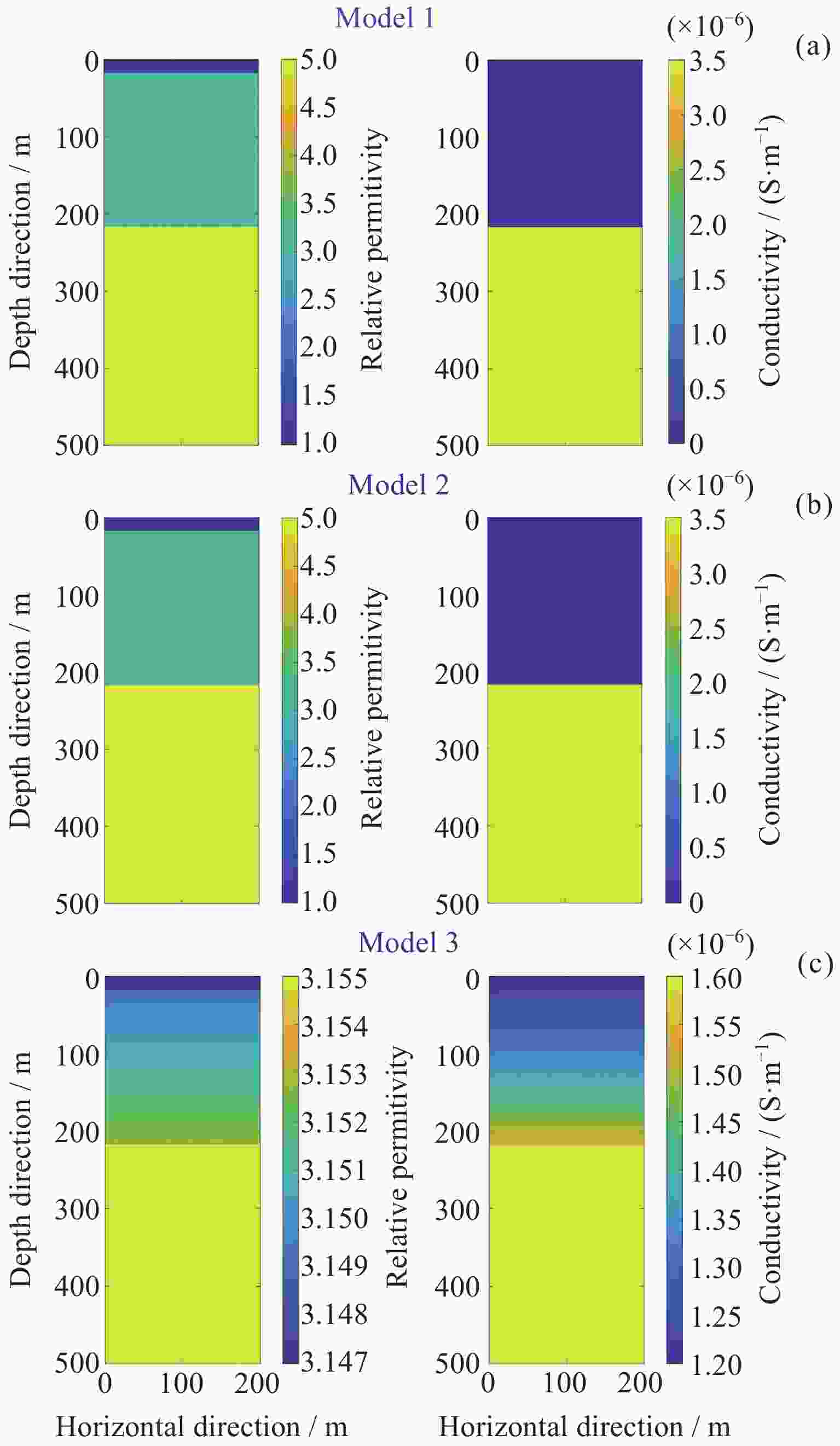
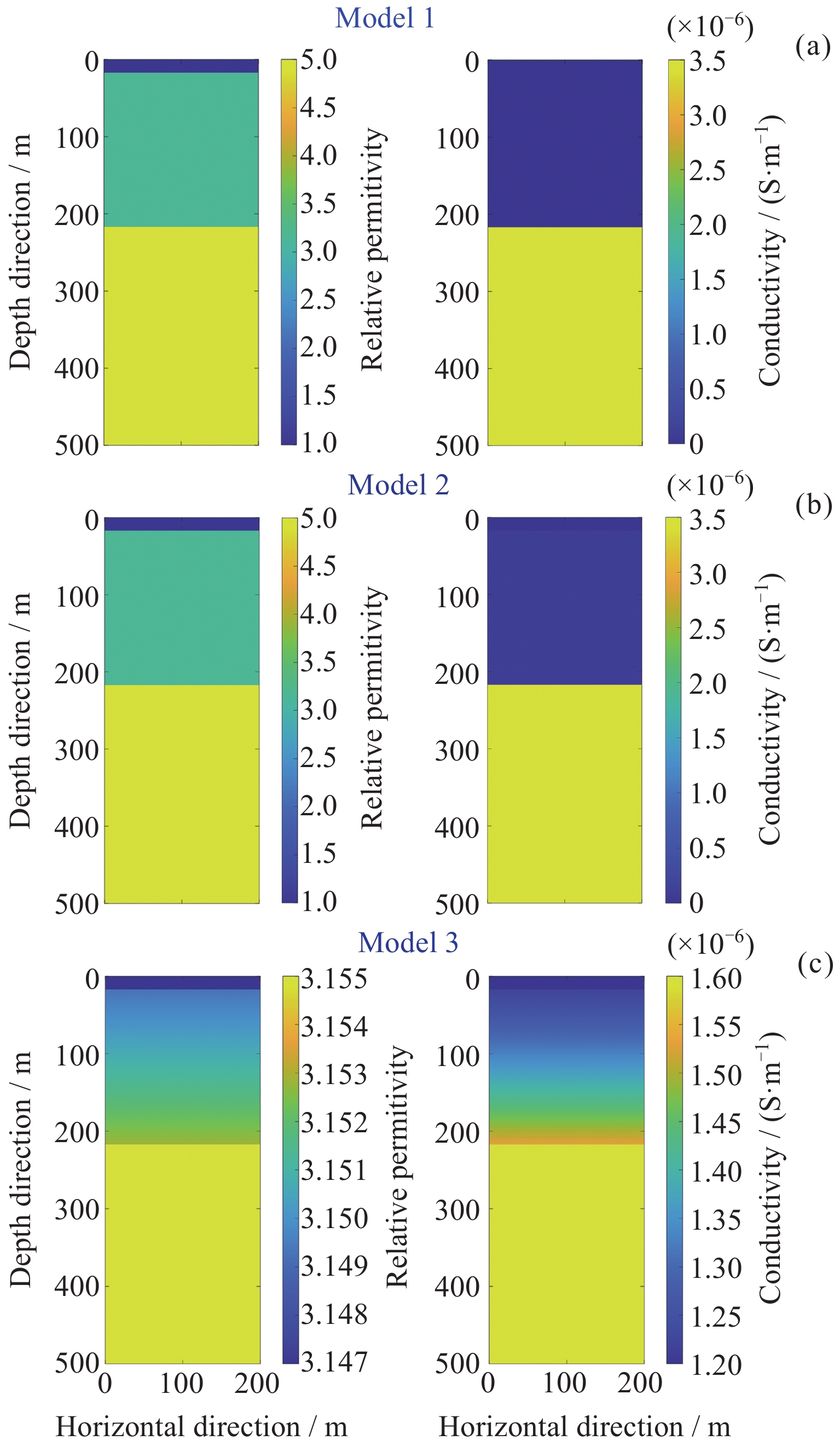
图 2 三种不同衰减机制的介电模型
Figure 2. Dielectric models with three different attenuation mechanisms
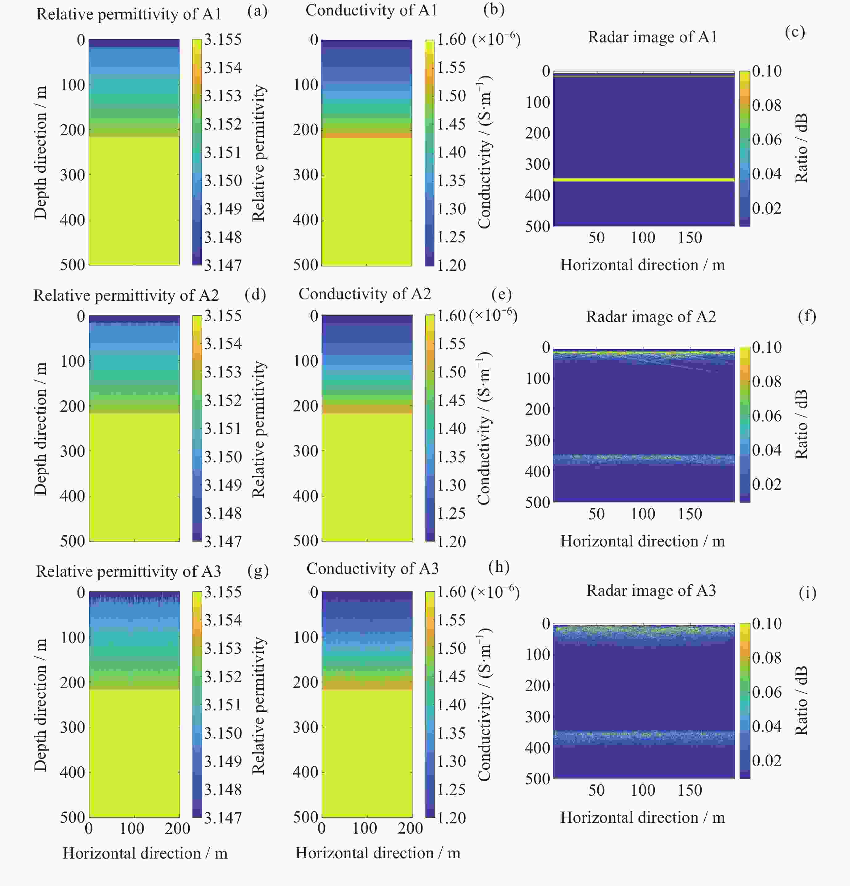
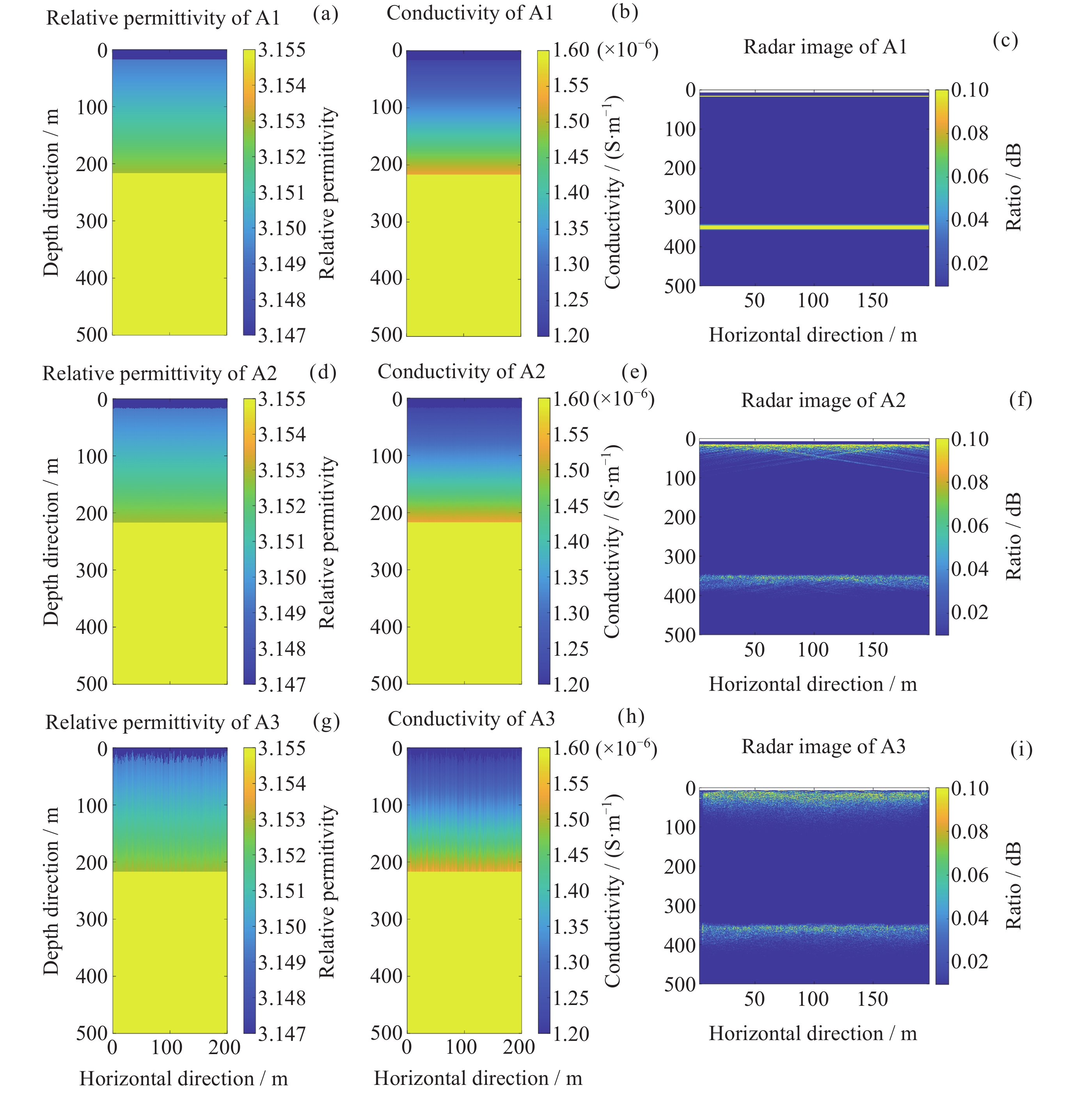
图 3 场景A1, A2, A3的介质模型及雷达图像
Figure 3. Medium model and radargram of A1, A2, A3 scenarios
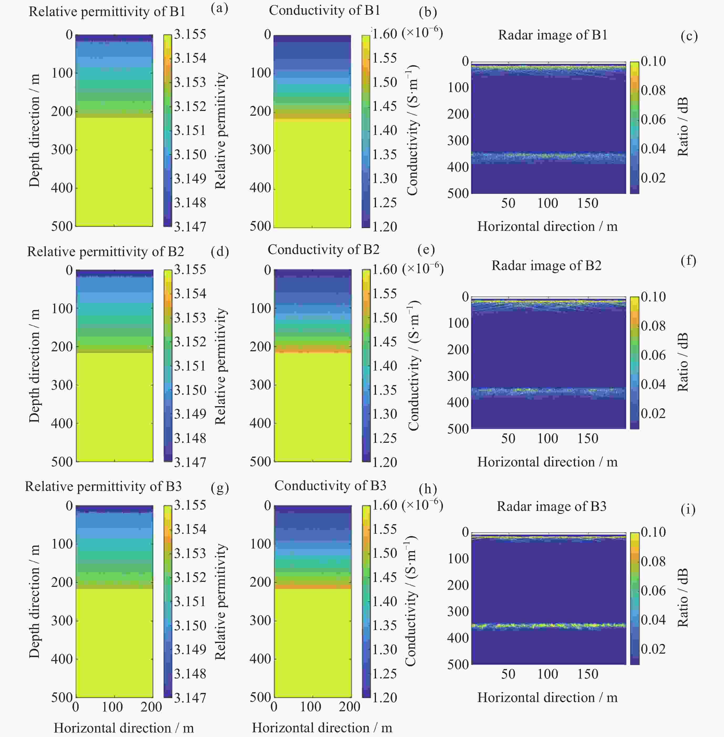
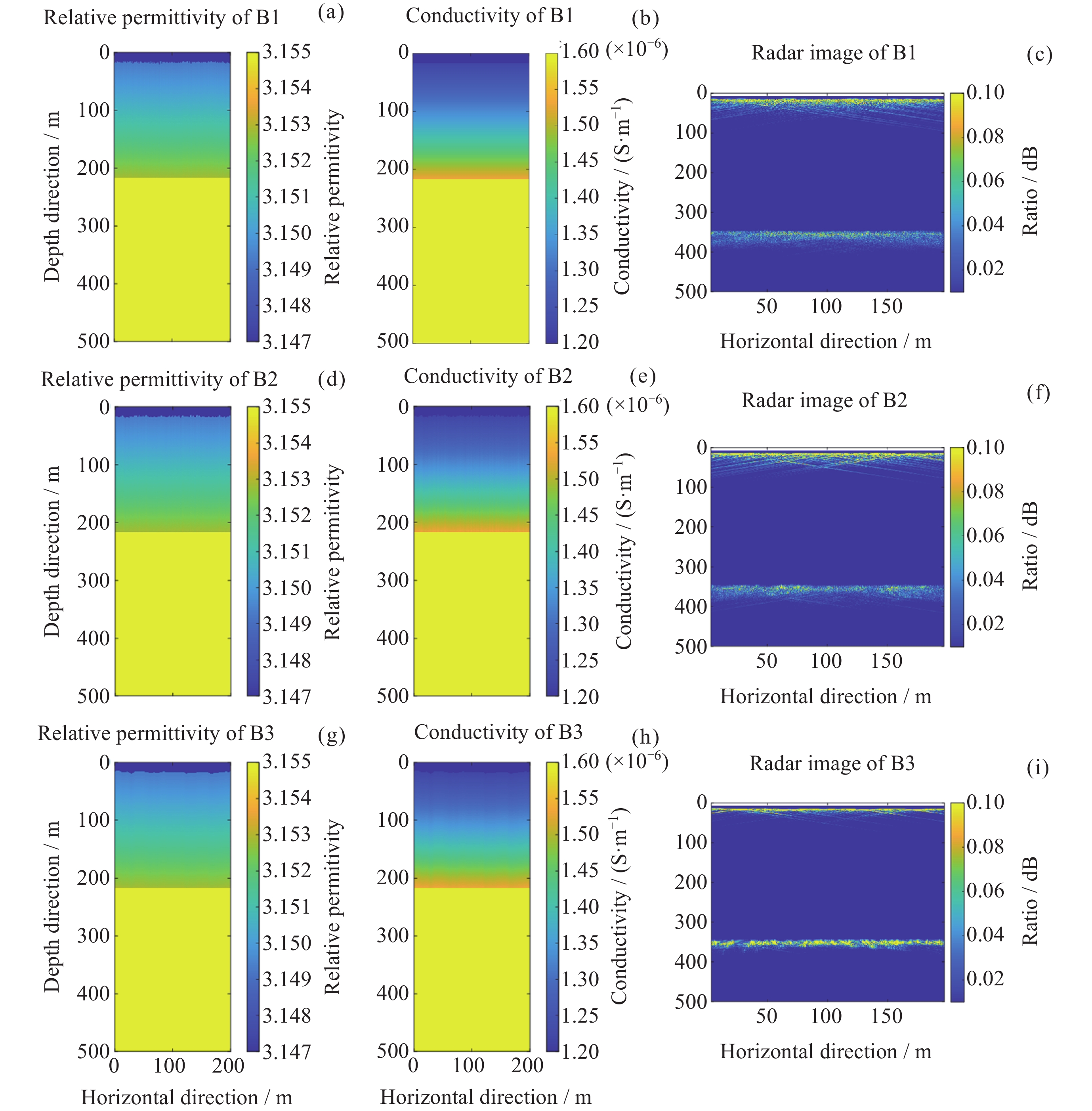
图 4 场景B1, B2, B3的介质模型及雷达图像
Figure 4. Medium model and radargram of B1, B2, B3 scenarios
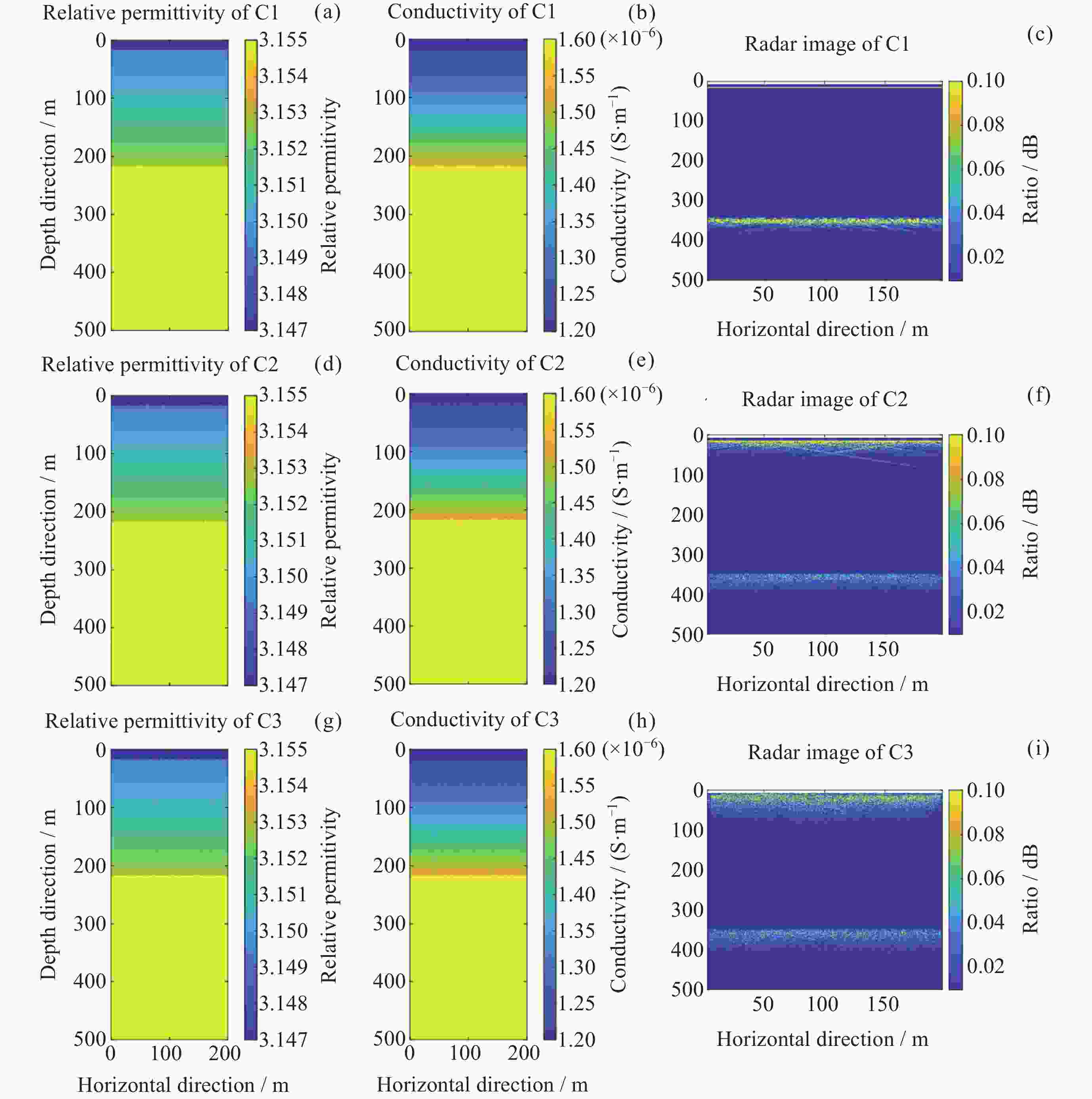
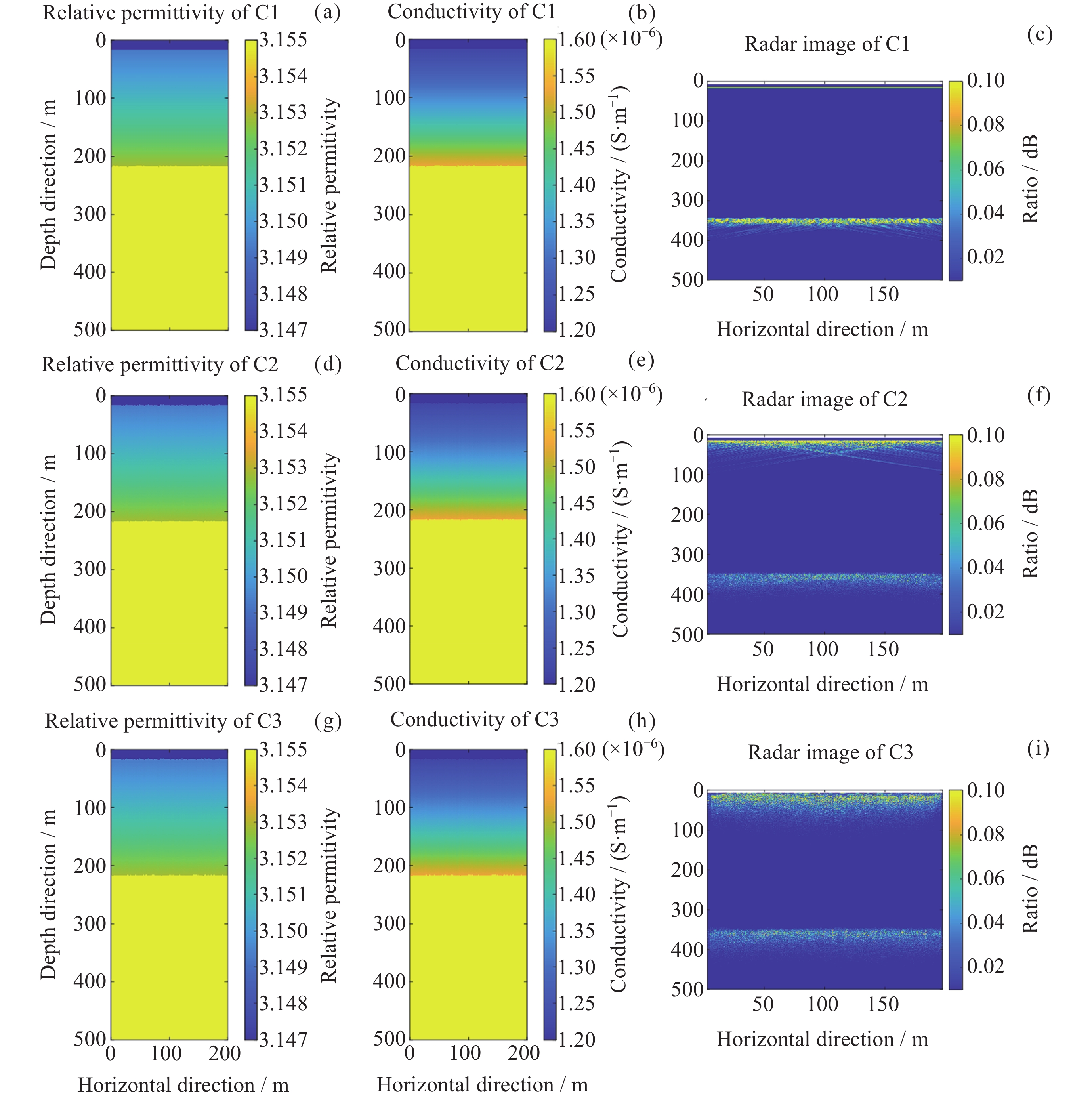
图 5 场景C1, C2, C3的介质模型及雷达图像
Figure 5. Medium model and radargram of C1, C2, C3 scenarios
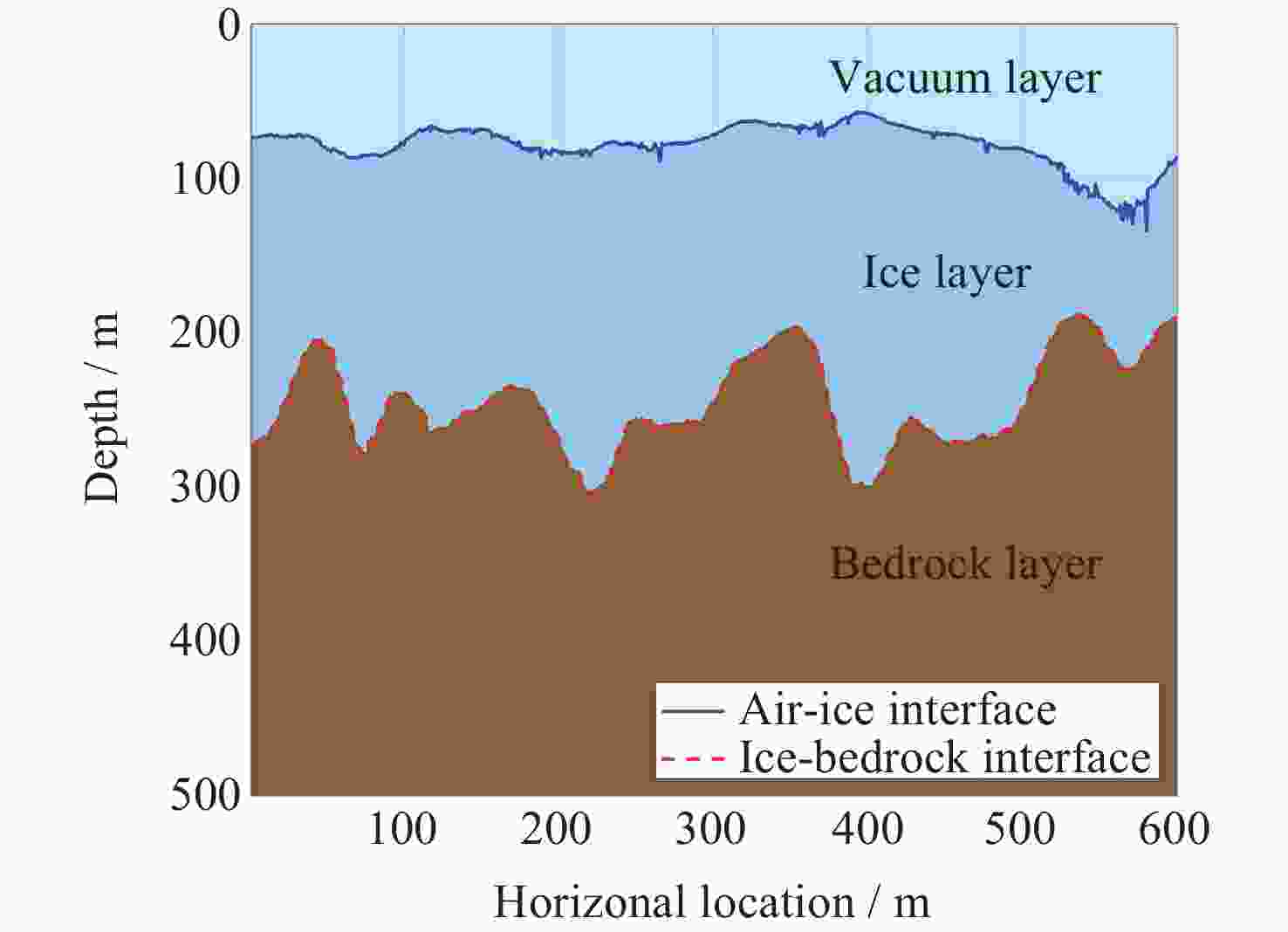
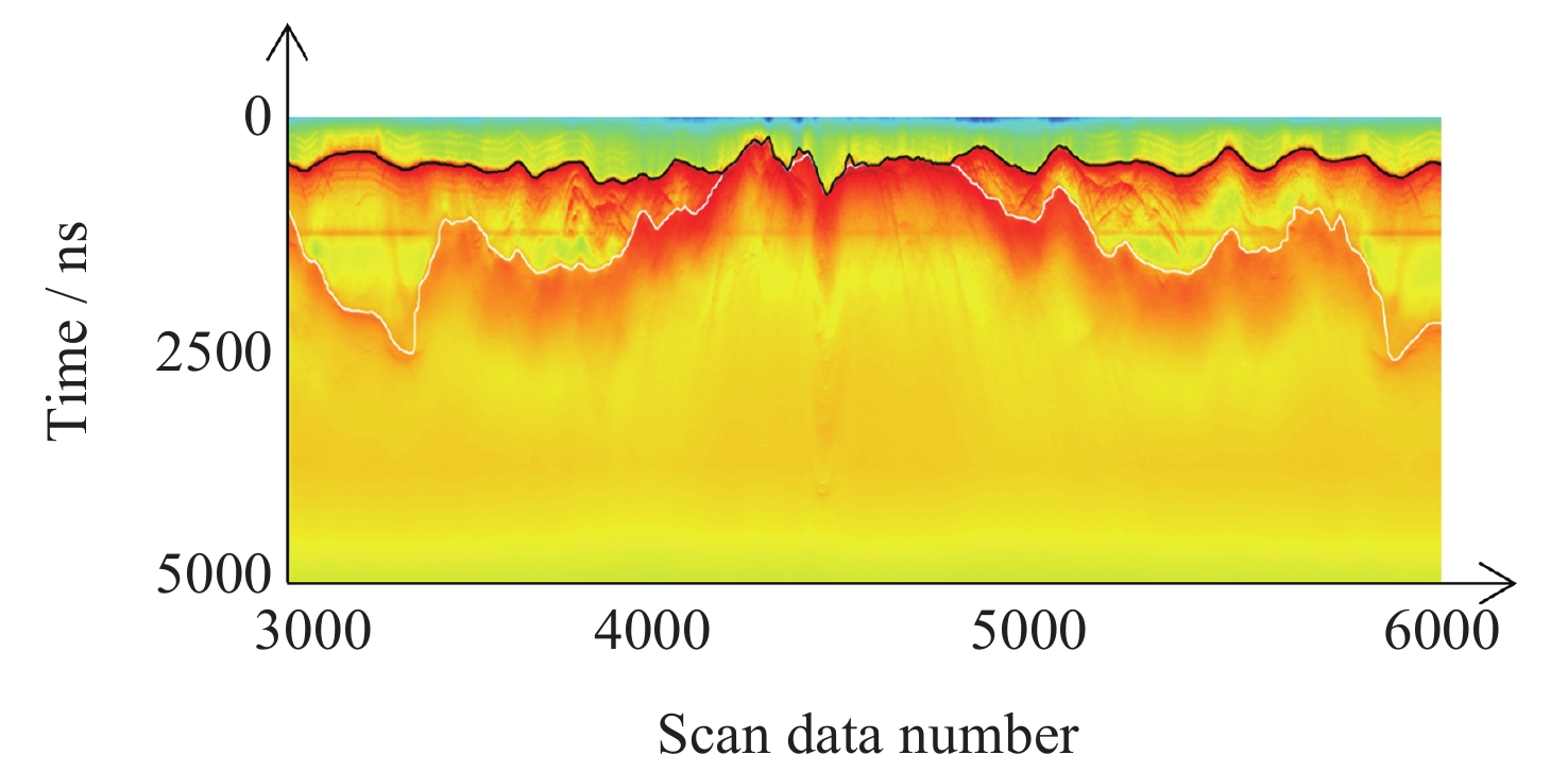
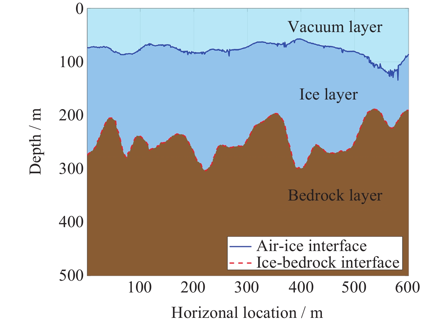
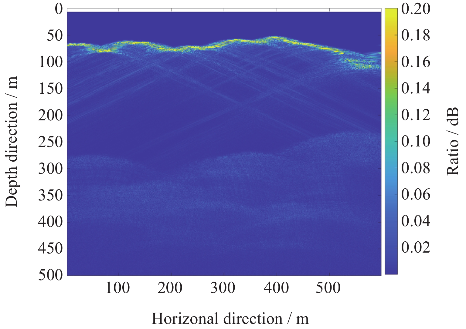
图 7 处理后的老虎沟12号冰川冰表/冰底地形几何数据(测点6900~7500)
Figure 7. Processed geometric data of glacier surface and basal topography in Laohugou Glacier No.12 (sampling points 6900~7500)
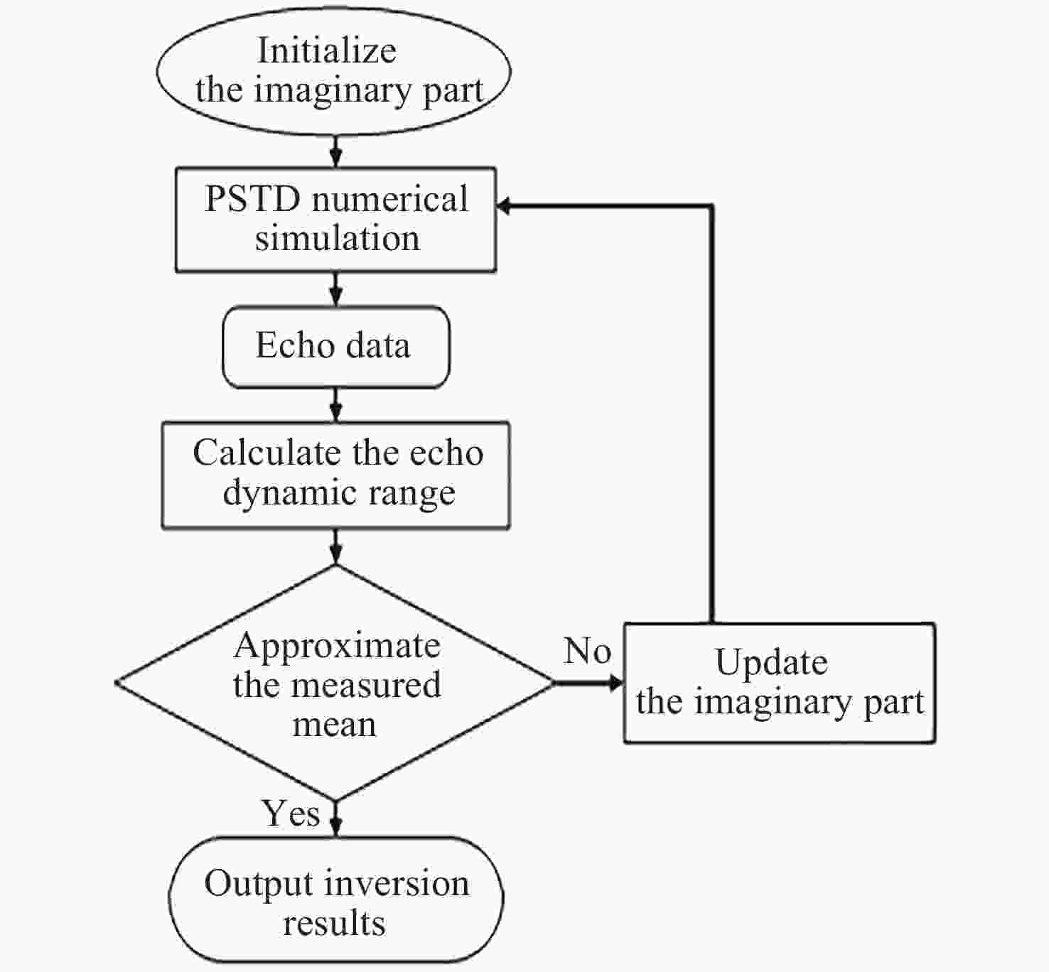
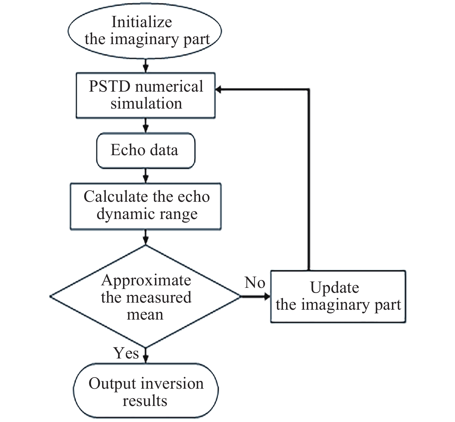
图 10 冰层介电常数虚部值反演方法流程
Figure 10. Flowchart of the inversion method for the imaginary part of dielectric constant in ice layer
表 1 仿真中使用的参数
Table 1. Parameters used in simulation
参数名称 参数值 探测器参数 飞行高度/m 150 雷达参数 中心频率/MHz 550 带宽/MHz 300 信号形式 高斯脉冲 模拟域参数 域宽度/m 200 域高度/m 500  下载: 导出CSV
表 2 三种介质模型及其衰减机制
Table 2. Three media models and their attenuation mechanisms
介质模型编号 实部$ {\varepsilon }' $ 虚部$ {\varepsilon {''}}$ 衰减机制 1 3.170 0 无吸收衰减 2 3.170 3.5×10⁻⁶ 恒定吸收衰减 3 3.149~3.153 (3.99~5.01)×10–6 动态吸收衰减
下载: 导出CSV
表 3 三种模型的回波动态范围
Table 3. Echo dynamic range of three models
介质模型
编号冰表回波
强度/dB冰底回波
强度/dB回波动态
范围/dB1 21.998 8.317 13.681 2 21.998 8.280 13.718 3 21.925 8.331 13.594
下载: 导出CSV
表 4 不同粗糙冰表的数值仿真结果
Table 4. Numerical simulation results of different rough ice surfaces
场景编号 均方根高度/m 相关长度/m 冰表回波强度/dB 冰底回波强度/dB 回波动态范围/dB A1 0 1.1 21.925 7.943 13.983 A2 0.55 1.1 –15.570 –23.124 7.554 A3 5.50 1.1 –19.971 –21.664 1.693 B1 1.1 0.55 –14.422 –22.331 7.909 B2 1.1 1.65 –10.095 –18.510 8.415 B3 1.1 5.50 –5.190 –12.131 6.942
下载: 导出CSV
表 5 粗糙冰底的数值仿真结果
Table 5. Numerical simulation results of rough ice bottoms
场景编号 冰表均方根高度/m 冰表相关长度/m 冰表回波强度/dB 冰底回波强度/dB 回波动态范围/dB C1 0 1.1 21.925 –8.141 30.067 C2 0.55 1.1 –15.570 –21.017 5.446 C3 5.50 1.1 –19.972 –22.883 2.911
下载: 导出CSV
表 6 四种场景的回波动态范围
Table 6. Echo dynamic range for four scenarios
场景编号 冰表均方根高度/m 冰表相关长度/m 冰底均方根高度/m 冰底相关长度/m 回波动态范围/dB A1 0 1.1 0 1.1 13.983 A3 5.50 1.1 0 1.1 1.693 C1 0 1.1 0.55 1.65 30.067 C3 5.50 1.1 0.55 1.65 2.911
下载: 导出CSV
表 7 仿真参数列表
Table 7. Parameters used in simulation
参数名称 参数值 探测器参数 飞行高度/m 150 雷达参数 中心频率/MHz 550 带宽/MHz 300 信号形式 高斯脉冲 模拟域参数 域宽度/m 600 域高度/m 500
下载: 导出CSV
表 8 迭代中冰层介电常数虚部与回波动态范围的关系
Table 8. Relationship between ice layer dielectric constant imaginary part and echo dynamic range during iteration
冰层介电常数虚部$ {\varepsilon {''}} $ 回波动态范围/dB 1.0×10⁻³ 26.071 9.0×10⁻⁴ 25.233 8.0×10⁻⁴ 24.338 7.0×10⁻⁴ 23.443 6.0×10⁻⁴ 22.549 5.0×10⁻⁴ 21.654
下载: 导出CSV
-
[1] PENG X Q, ZHANG T J, FRAUENFELD O W, et al. A holistic assessment of 1979–2016 global cryospheric extent[J]. Earth’s Future, 2021, 9(8): e2020EF001969 doi: 10.1029/2020EF001969 [2] Intergovernmental Panel on Climate Change. Climate change 2021 – the physical science basis[J]. Chemistry International, 2021, 43(3): 22-23 [3] BOGORODSKY V V, BENTLEY C R, GUDMANDSEN P E. Radioglaciology[M]. Dordrecht: Springer, 1985 [4] 崔祥斌, 孙波, 张向培, 等. 极地冰盖冰雷达探测技术的发展综述[J]. 极地研究, 2009, 21(4): 322-335CUI X B, SUN B, ZHANG X P, et al. A review of ice radar’s technical development in polar ice sheet investigation[J]. Chinese Journal of Polar Research, 2009, 21(4): 322-335 [5] 赵轩茹. 近十年内中国冰川变化及驱动因素分析[D]. 湘潭: 湖南科技大学, 2020ZHAO X R. Analysis of China’s Glacier Changes and Driving Factors During the Last Decade[D]. Xiangtan: Hunan University of Science and Technology, 2020 [6] 曹梅盛, 李新, 陈贤章, 等. 冰冻圈遥感[M]. 北京: 科学出版社, 2006CAO M S, LI X, CHEN X Z, et al. Remote Sensing of Cryosphere[M]. Beijing: Science Press, 2006 [7] KUCHIKULLA A, GOGINENI S, KANAGARATNAM P, et al. A wideband radar depth sounder for measuring the thickness of glacial ice[C]//IGARSS 2004. 2004 IEEE International Geoscience and Remote Sensing Symposium. Anchorage, AK: IEEE, 2004: 108 [8] YAN J B, LI J L, RODRIGUEZ-MORALES F, et al. Measurements of in-flight cross-track antenna patterns of radar depth sounder/imager[J]. IEEE Transactions on Antennas and Propagation, 2012, 60(12): 5669-5678 doi: 10.1109/TAP.2012.2211327 [9] HALE R, MILLER H, GOGINENI S, et al. Multi-channel ultra-wideband radar sounder and imager[C]//2016 IEEE International Geoscience and Remote Sensing Symposium (IGARSS). Beijing: IEEE, 2016: 2112-2115 [10] CUI X B, WANG T T, SUN B, et al. Chinese radioglaciological studies on the Antarctic ice sheet: progress and prospects[J]. Advances in Polar Science, 2017, 28(3): 161-170 [11] CUI X B, JEOFRY H, GREENBAUM J S, et al. Bed topography of princess Elizabeth land in east Antarctica[J]. Earth System Science Data, 2020, 12(4): 2765-2774 doi: 10.5194/essd-12-2765-2020 [12] TAFLOVE A, HAGNESS S C, PIKET-MAY M. Computational electromagnetics: the finite-difference time-domain method[J]. The Electrical Engineering Handbook, 2005 629670 [13] LIU Q H. The PSTD algorithm: A time‐domain method requiring only two cells per wavelength[J]. Microwave and Optical Technology Letters, 1998, 15(3): 158-165 [14] TEDESCO M. Remote Sensing and the Cryosphere[M]. Washington: John Wiley & Sons, Ltd, 2015: 1-16 [15] 肖鹏, 于志同, 陈卓奇, 等. 天基穿冰雷达系统: 机遇与挑战[J]. 雷达学报, 2022, 11(3): 479-498 doi: 10.12000/JR21196XIAO P, YU Z T, CHEN Z Q, et al. Orbital radar sounding of Earth’s ice sheets: opportunities and challenges[J]. Journal of Radars, 2022, 11(3): 479-498 doi: 10.12000/JR21196 [16] LIU Q H. Large-scale simulations of electromagnetic and acoustic measurements using the PseudoSpectral Time-Domain (PSTD) algorithm[J]. IEEE Transactions on Geoscience and Remote Sensing, 1999, 37(2): 917-926 doi: 10.1109/36.752210 [17] HUO Q H, ZHAO G. Review of PSTD methods for transient electromagnetics[J]. International Journal of Numerical Modelling: Electronic Networks, Devices and Fields, 2004, 17(3): 299-323 doi: 10.1002/jnm.544 [18] LEI Y, HAYNES M S, ARUMUGAM D, et al. A 2-D PseudoSpectral Time-Domain (PSTD) simulator for large-scale electromagnetic scattering and radar sounding applications[J]. IEEE Transactions on Geoscience and Remote Sensing, 2020, 58(6): 4076-4098 doi: 10.1109/TGRS.2019.2960751 [19] LEI Y, RAGUSO M C, MASTROGIUSEPPE M, et al. Validation of a PseudoSpectral Time-Domain (PSTD) planetary radar sounding simulator with SHARAD radar sounding data[J]. IEEE Transactions on Geoscience and Remote Sensing, 2022, 60: 1-15 doi: 10.1109/tgrs.2022.3168283 [20] 郭立新, 王蕊, 吴振森. 随机粗糙面散射的基本理论与方法[M]. 北京: 科学出版社, 2010GUO L X, WANG R, WU Z S. Basic Theory and Method of Random Rough Surface Scattering[M]. Beijing: Science Press, 2010 [21] TSANG L, KONG J A, DING K H, et al. Scattering and emission by a periodic rough surface[M]//Scattering of Electromagnetic Waves: Numerical Simulations. Washington: John Wiley & Sons, Inc., 2002: 61-110 [22] LU C C, CHEW W C. A multilevel algorithm for solving a boundary integral equation of wave scattering[J]. Microwave and Optical Technology Letters, 1994, 7(10): 466-470 doi: 10.1002/mop.4650071013 [23] 谢处方, 饶克谨. 电磁场与电磁波[M]. 2版. 北京: 高等教育出版社, 2006XIE C F, RAO K J. Electromagnetic Fields and Waves[M]. 2nd ed. Beijing: Higher Education Press, 2006 [24] VAN DER VEEN C J. Fundamentals of Glacier Dynamics[M]. 2nd ed. Boca Raton: CRC Press, 2013 [25] LEDUC-LEBALLEUR M, PICARD G, MIALON A, et al. Modeling L-band brightness temperature at Dome C in Antarctica and comparison with SMOS observations[J]. IEEE Transactions on Geoscience and Remote Sensing, 2015, 53(7): 4022-4032 doi: 10.1109/TGRS.2015.2388790 [26] MÄTZLER C. Thermal Microwave Radiation: Applications for Remote Sensing[M]. London: The Institution of Engineering and Technology, 2006 [27] Hansun S. A new approach of moving average method in time series analysis[C]//2013 Conference on New Media Studies (CoNMedia). Tangerang: IEEE, 2013: 1-4 [28] LAI J L, XU Y, ZHANG X P, et al. Comparison of dielectric properties and structure of lunar regolith at Chang’E-3 and Chang’E-4 landing sites revealed by ground-penetrating radar[J]. Geophysical Research Letters, 2019, 46(22): 12783-12793 doi: 10.1029/2019GL084458 [29] LI C L, SU Y, PETTINELLI E, et al. The Moon’s farside shallow subsurface structure unveiled by Chang’E-4 Lunar Penetrating Radar[J]. Science Advances, 2020, 6(9): eaay6898 doi: 10.1126/sciadv.aay6898 [30] 张宇, 张晓娟, 方广有. 大尺度分层介质电特性参数的反演方法研究[J]. 物理学报, 2013, 62(4): 044204 doi: 10.7498/aps.62.044204ZHANG Y, ZHANG X J, FANG G Y. A data inversion method for electromagnetic scattering from large-scale layered medium[J]. Acta Physica Sinica, 2013, 62(4): 044204 doi: 10.7498/aps.62.044204 [31] LAMBOT S, SLOB E C, VAN DEN BOSCH I, et al. Estimating soil electric properties from monostatic ground-penetrating radar signal inversion in the frequency domain[J]. Water Resources Research, 2004, 40(4): W04205 doi: 10.1029/2003wr002095 -
-

 下载:
下载:

计量
- 文章访问数: 922
- HTML全文浏览量: 450
- PDF下载量: 32
-
被引次数:
0(来源:Crossref)
0(来源:其他)

