


Recent Advances of the SDGSAT-1 for Supporting Global SDG Monitoring and Evaluation
doi: 10.11728/cjss2026.04.2026-yg11 cstr: 32142.14.cjss.2026-yg11
-
Abstract: As a dedicated scientific satellite tailored to advance the implementation of the United Nations 2030 Agenda for Sustainable Development (2030 Agenda), the Sustainable Development Goals Satellite 1 (SDGSAT-1) has entered its fifth year of in-orbit operation. This satellite has witnessed a rapid diversification in its research applications. The satellite’s data have been used by more than 116 countries, and over 220 peer-reviewed papers have been published. Such remarkable research growth is attributable to the high-quality data products derived from SDGSAT-1’s technological innovations, alongside its open data access policy and sustainably maintained operational status underpinned by the SDGSAT-1 Open Science Program. This paper presents a state-of-the-art review of the mission’s research progress over the past two years and elaborates on the future development prospects for ongoing global SDG monitoring and assessment.
-
Key words:
- SDGSAT-1 /
- Earth observation /
- Sustainable Development Goals (SDGs) /
- Remote sensing
-
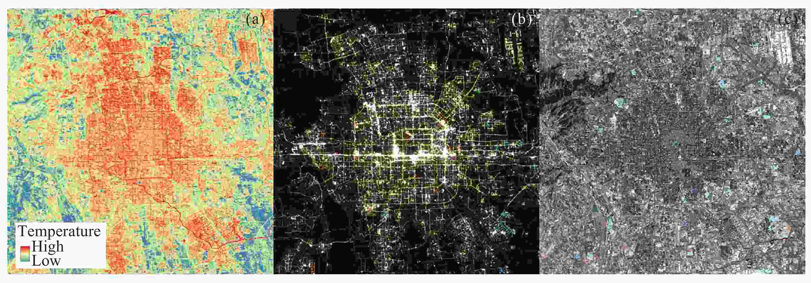
Figure 1. Images of central Beijing captured by SDGSAT-1. (a) Nighttime band 2 TIS image, captured on 11 March 2026. (b) Nighttime RGB-composite GLI image, captured on 11 March 2026. (c) Daytime RGB-composite MSI image, captured on 2 February 2026
Table 1. Technical parameters of SDGSAT-1 sensors
Type Parameter Specification Multispectral imager Swath width 300 km Spatial resolution 10 m Designed radiometric accuracy Relative: ≤2%
Absolute: ≤5%Bands and central wavelengths Band 1 (deep blue): 400.63 nm Band 2 (deep blue): 438.47 nm
Band 3 (blue): 495.10 nm
Band 4 (green): 553.23 nm
Band 5 (red): 656.75 nm
Band 6 (red edge): 776.12 nm
Band 7 (near-infrared): 854.02 nmThermal infrared spectrometer Swath width 300 km Spatial resolution 30 m Designed radiometric accuracy Relative: ≤5%
Absolute: ≤1 K@300 KBands and central wavelengths Band 1: 9.35 μm
Band 2: 10.73 μm
Band 3: 11.72 μmGlimmer imager Swath width 300 km Spatial resolution Panchromatic: 10 m, RGB: 40 m Designed radiometric accuracy Relative: ≤2%
Absolute: ≤5%Bands and central wavelengths Blue band: 478.87 nm
Green band: 561.20 nm
Red band: 734.25 nm
Panchromatic band: 680.72 nm 下载: 导出CSV
Table 2. Orbit parameters of SDGSAT-1
Parameter Specification Type Sun-synchronous orbit Orbit period/min 90 Revisit period/d 11 Altitude/km 505 Inclination angle/(°) 97.5
下载: 导出CSV
-
[1] United Nations. The Sustainable Development Goals Report 2025[R/OL]. (2025-7-14). https://unstats.un.org/sdgs/report/2025/ [2] ZHAO Q, YU L. Advancing sustainable development goals through earth observation satellite data: current insights and future directions[J]. Journal of Remote Sensing, 2025, 5: 0403 doi: 10.34133/remotesensing.0403 [3] GUO H D, DOU C Y, LIANG D, et al. SDGSAT-1: capabilities for monitoring and evaluating SDG indicators[J]. Chinese Journal of Space Science, 2024, 44(4): 677-686 [4] GUO H D, DOU C Y, LIANG D, et al. SDGSAT-1: a professional scientific satellite for monitoring SDG indicators[J/OL]. Proceedings of the IEEE, (2026-01-12). https://ieeexplore.ieee.org/document/11334168 [5] GUO H D, DOU C Y, LIANG D, et al. The SDGSAT-1 mission and its role in monitoring SDG indicators[J]. Remote Sensing of Environment, 2025, 328: 114885 doi: 10.1016/j.rse.2025.114885 [6] YAN L, HU Y H, DOU C Y, et al. Radiometric calibration of SDGSAT-1 nighttime light payload[J]. IEEE Transactions on Geoscience and Remote Sensing, 2024, 62: 1000715 doi: 10.1109/tgrs.2024.3370572 [7] HU Y H, LI X M, DOU C Y, et al. Absolute radiometric calibration evaluation of the thermal infrared spectrometer onboard SDGSAT-1[J]. International Journal of Digital Earth, 2023, 16(2): 4492-4511 doi: 10.1080/17538947.2023.2274418 [8] CUI Z Z, MA C, ZHANG H, et al. Vicarious radiometric calibration of the multispectral imager onboard SDGSAT-1 over the Dunhuang calibration site, China[J]. Remote Sensing, 2023, 15(10): 2578 doi: 10.3390/rs15102578 [9] TAN P, LV M Y, GUO H D, et al. A misalignments correction method for SDGSAT-1 glimmer imagery based on object detection and cross correlation[J]. IEEE Transactions on Geoscience and Remote Sensing, 2025, 63: 5630013 doi: 10.1109/tgrs.2025.3584039 [10] YIN Z Q, WU M Q, NIU Z, et al. Geometric registration of SDGSAT-1 glimmer images guided by OpenStreetMap road network[J]. IEEE Transactions on Geoscience and Remote Sensing, 2025, 63: 5650213 doi: 10.1109/tgrs.2025.3627107 [11] ZHANG H Q, REN H Z, LI F G, et al. Atmospheric correction for nighttime light image using radiative transfer model[J]. IEEE Transactions on Geoscience and Remote Sensing, 2025, 63: 4105016 [12] WANG C X, XU W, CHEN Z Q, et al. STARS: a novel gap-filling method for SDGSAT-1 nighttime light imagery using spatiotemporal and spectral synergy[J]. Remote Sensing of Environment, 2025, 322: 114720 doi: 10.1016/j.rse.2025.114720 [13] JIA M M, ZENG H H, CHEN Z Q, et al. Nighttime light in China’s coastal zone: the type classification approach using SDGSAT-1 Glimmer Imager[J]. Remote Sensing of Environment, 2024, 305: 114104 doi: 10.1016/j.rse.2024.114104 [14] YAN Y Y, ZHANG R, WANG Z M, et al. Classification of nighttime light types in China’s nature protected areas based on SDGSAT-1[J]. International Journal of Digital Earth, 2025, 18(1): 2496791 doi: 10.1080/17538947.2025.2496791 [15] CAO L Q, ZHAO H, WANG D, et al. A novel land surface temperature retrieval method using channel correlation for atmospheric parameter modeling from SDGSAT-1 data[J]. Remote Sensing of Environment, 2026, 334: 115190 doi: 10.1016/j.rse.2025.115190 [16] OUYANG X Y, SUN Z C, ZHOU S G, et al. Urban land surface temperature retrieval with high-spatial resolution SDGSAT-1 thermal infrared data[J]. Remote Sensing of Environment, 2024, 312: 114320 doi: 10.1016/j.rse.2024.114320 [17] ZHONG X, ZHAO L H, REN P, et al. Land surface emissivity retrieval from SDGSAT-1: comparison of LSE products with different spatial resolutions[J]. International Journal of Digital Earth, 2024, 17(1): 2297940 doi: 10.1080/17538947.2023.2297940 [18] ZHOU M, GUO H D, OUYANG X Y, et al. Land surface temperature retrieval from SDGSAT-1: assessment of different retrieval algorithms with different atmospheric reanalysis data[J]. International Journal of Digital Earth, 2025, 18(1): 2492314 doi: 10.1080/17538947.2025.2492314 [19] ZHU M, WANG Q Y, YU J N, et al. First assessment of SDGSAT-1 TIS thermal infrared bands calibration using Landsat 9 TIRS-2[J]. IEEE Journal of Selected Topics in Applied Earth Observations and Remote Sensing, 2024, 17: 6224-6232 doi: 10.1109/JSTARS.2024.3400508 [20] ZHU M, ZHAO X, ZOU L, et al. Cross calibration of SDGSAT-1/TIS thermal infrared bands with FY-4A/AGRI[J]. IEEE Journal of Selected Topics in Applied Earth Observations and Remote Sensing, 2024, 17: 6233-6240 doi: 10.1109/JSTARS.2024.3396228 [21] YAN L, QIAO E C, DOU C Y, et al. Three-year On-orbit radiometric performance of the SDGSAT-1 multispectral imager (MSI)[J]. IEEE Journal of Selected Topics in Applied Earth Observations and Remote Sensing, 2025, 18: 16707-16721 doi: 10.1109/JSTARS.2025.3583034 [22] LI W K, TANG S L, TIAN L Q, et al. Assessing on-orbit radiometric performance of SDGSAT-1 MII for turbid water remote sensing[J]. Remote Sensing of Environment, 2025, 321: 114683 doi: 10.1016/j.rse.2025.114683 [23] JIANG N J, DOU C Y, TANG Y W, et al. Derivation of tasseled cap transformation coefficients for SDGSAT-1 Multispectral Imager at-sensor reflectance data[J]. International Journal of Digital Earth, 2024, 17(1): 2413885 doi: 10.1080/17538947.2024.2413885 [24] XU H Q, SU G F, HE G J, et al. Exploring the ecological potential of SDGSAT-1 MII and TIS data: Methods, applications, and comparisons[J]. Remote Sensing of Environment, 2025, 330: 114976 doi: 10.1016/j.rse.2025.114976 [25] QIU Y J, LI X M, YAN L, et al. Synergic sensing of light and heat emitted by offshore oil and gas platforms in the South China Sea[J]. International Journal of Digital Earth, 2024, 17(1): 2441932 doi: 10.1080/17538947.2024.2441932 [26] ZHANG K L, FU D J, TANG J S, et al. Synergistic day-night multi-modal framework for offshore gas flare detection using SDGSAT-1 in the Southeast Asian Seas[J]. Remote Sensing of Environment, 2026, 337: 115337 doi: 10.1016/j.rse.2026.115337 [27] ZHANG W C, WANG Q Y, LI L Y, et al. GTSD: glimmer and thermal infrared remote sensing dataset for night-time ship detection under thin clouds[J]. International Journal of Digital Earth, 2025, 18(1): 2532781 doi: 10.1080/17538947.2025.2532781 [28] YE L, LONG T F, JIAO W L, et al. Fairly assessing nighttime urban cooling performance with a novel satellite-based index[J]. Sustainable Cities and Society, 2026, 141: 107296 doi: 10.1016/j.scs.2026.107296 [29] WANG Q Y, BIAN J, HU Z Y, et al. High-resolution urban heat island analysis using SDGSAT-1 thermal infrared and glimmer data: the case of mainland Shanghai[J]. International Journal of Digital Earth, 2025, 18(2): 2553792 doi: 10.1080/17538947.2025.2553792 [30] ZHONG X, ZHAO L H, REN P, et al. Downscaled high spatial resolution images from automated machine learning for assessment of urban structure effects on land surface temperatures[J]. Building and Environment, 2024, 264: 111934 doi: 10.1016/j.buildenv.2024.111934 [31] LIU L S, LI Q Y, NIU Z G, et al. Comparative study on information extraction of urban wetlands and its thermal environment using the SDGSAT-1 data[J]. International Journal of Digital Earth, 2024, 17(1): 2310728 doi: 10.1080/17538947.2024.2310728 [32] FU B L, WU Y, ZHANG S R, et al. Synergistic retrieval of mangrove vital functional traits using field hyperspectral and satellite data[J]. International Journal of Applied Earth Observation and Geoinformation, 2024, 131: 103963 doi: 10.1016/j.jag.2024.103963 [33] FEROZ A, LIANG S, LI G Y, et al. Debris-covered glaciers mapping based on machine learning and multi-source satellite images over Eastern Pamir[J]. Big Earth Data, 2025, 9(2): 265-297 doi: 10.1080/20964471.2025.2463726 [34] DOU C Y, TANG Y W, JIANG N J, et al. Analysis of Sichuan wildfire based on the first synergetic observation from three payloads of SDGSAT-1[J]. The Innovation, 2024, 5(6): 100707 doi: 10.1016/j.xinn.2024.100707 [35] UNDRR. Assessment of Los Angeles Wildfire Based on Multisource Remote Sensing Data[R/OL]. (2025-01-22). https://www.preventionweb.net/publication/assessment-los-angeles-wildfire-based-multisource-remote-sensing-data [36] ZHANG S Y, MA Y, CHEN H Y, et al. The spatiotemporal fusion for nighttime light based on SDGSAT-1 and VIIRS data[J]. IEEE Transactions on Geoscience and Remote Sensing, 2025, 63: 4702919 doi: 10.1109/tgrs.2025.3560092 [37] BIAN J H, AHMAD KHAN T, LI A N, et al. A new spatiotemporal fusion model for integrating VIIRS and SDGSAT-1 Nighttime light data to generate daily SDGSAT-1 like observations[J]. International Journal of Digital Earth, 2025, 18(1): 2472912 doi: 10.1080/17538947.2025.2472912 [38] GAO Z R, LI X J, ZUO L J, et al. Unveiling soil salinity patterns in soda saline-alkali regions using Sentinel-2 and SDGSAT-1 thermal infrared data[J]. Remote Sensing of Environment, 2025, 322: 114708 doi: 10.1016/j.rse.2025.114708 [39] JIANG D M D, LI Y M, LIU Q H, et al. Evaluating the Sustainable Development Science Satellite 1 (SDGSAT-1) multi-spectral data for river water mapping: a comparative study with Sentinel-2[J]. Remote Sensing, 2024, 16(15): 2716 doi: 10.3390/rs16152716 [40] JIA M M, ZHANG R, ZHAO C P, et al. Synergistic estimation of mangrove canopy height across coastal China: Integrating SDGSAT-1 multispectral data with Sentinel-1/2 time-series imagery[J]. Remote Sensing of Environment, 2025, 323: 114719 doi: 10.1016/j.rse.2025.114719 [41] FU B L, WU Y, ZHANG L, et al. Cross-scenario transfer learning for estimating mangrove nitrogen and phosphorus content from field hyperspectral data to SDGSAT-1 and Sentinel-2 images[J]. Remote Sensing of Environment, 2025, 329: 114923 doi: 10.1016/j.rse.2025.114923 [42] LEVIN N, COOPER R M, KARK S. Quantifying night sky brightness as a stressor for coastal ecosystems in Moreton Bay, Queensland[J]. Remote Sensing, 2024, 16(20): 3828 doi: 10.3390/rs16203828 [43] LABROUSSE C, HASPEL C, LEVIN N. Quantifying the impact of the transition to LED lighting on night sky brightness and colour using ground-based measurements and satellite imagery[J]. Journal of Quantitative Spectroscopy and Radiative Transfer, 2025, 340: 109450 doi: 10.1016/j.jqsrt.2025.109450 [44] WEBER D, BOLLIGER J, ECKER K, et al. Night lights from space: potential of SDGSAT-1 for ecological applications[J]. Remote Sensing in Ecology and Conservation, 2025, 11(5): 495-509. doi: 10.1002/rse2.70011 [45] WANG L D, LV M Y, DOU C Y, et al. Evaluating the wilderness status of long-distance trails in the United States-Exploring the potential of SDGSAT-1 glimmer imager data[J]. Remote Sensing of Environment, 2025, 316: 114499 doi: 10.1016/j.rse.2024.114499 [46] PESARESI M, UHL J H, LU L L, et al. Compositing high-resolution SDGSAT-1 nighttime light data by ranking of structural image features[J]. Remote Sensing of Environment, 2026, 337: 115313 doi: 10.1016/j.rse.2026.115313 [47] SÁNCHEZ DE MIGUEL A. SDGSAT-1 EU+UK Plan-B[DS/OL]. (2025-12-18)[2026-04-24]. https://data.europa.eu/data/datasets/oai-zenodo-org-17970082?locale=mt [48] ANTEZANA LOPEZ F P, CASALLAS A, ZHOU G H, et al. High-resolution anthropogenic emission inventories with deep learning in northern South America[J]. Remote Sensing of Environment, 2025, 324: 114761 doi: 10.1016/j.rse.2025.114761 [49] FAHAD BAQA M, LU L L, WANG S Q, et al. How 2D/3D urban form shapes land surface temperature: a comparative analysis across four South Asian cities[J]. GIScience & Remote Sensing, 2026, 63(1): 2640263 doi: 10.1080/15481603.2026.2640263 [50] KHAN T A, BIAN J H, LI A N, et al. Estimation of electric power consumption at 10 m for Punjab, Pakistan, using ensemble machine learning model and spatiotemporal fused SDGSAT-1-like nighttime light data[J]. IEEE Transactions on Geoscience and Remote Sensing, 2026, 64: 4701717 doi: 10.1109/tgrs.2026.3663881 [51] BAQA M F, LU L L, GUO H D, et al. Investigating heat-related health risks related to local climate zones using SDGSAT-1 high-resolution thermal infrared imagery in an arid megacity[J]. International Journal of Applied Earth Observation and Geoinformation, 2025, 136: 104334 doi: 10.1016/j.jag.2024.104334 [52] AFRIANTO F, GRAHA D T R, PUSPORINI N, et al. Illuminating energy efficiency: satellite-guided insights for optimizing urban street lighting across Indonesian cities[J]. Indonesian Journal of Energy, 2025, 8(1): 16-36 [53] ZHANG Y, LI X. Assessment of central Sahel crisis by nighttime light imagery[J]. IEEE Journal of Selected Topics in Applied Earth Observations and Remote Sensing, 2025, 18: 13359-13371 doi: 10.1109/JSTARS.2025.3570758 [54] LI X S, SHEN T, KABO-BAH A T, et al. GGW-BDF: an online tool for using earth observation and Chinese ecosystem restoration experiences in support of the Great Green Wall initiative[J]. International Journal of Digital Earth, 2024, 17(1): 2364683 doi: 10.1080/17538947.2024.2364683 [55] LI J H, WANG Y, HUANG H L, et al. Low and uneven rural road lighting coverage in Africa[J]. Communications Earth & Environment, 2025, 6(1): 960 doi: 10.1038/s43247-025-02915-9 -
-

 下载:
下载:

图(1) / 表(2)
计量
- 文章访问数: 767
- HTML全文浏览量: 442
- PDF下载量: 27
-
被引次数:
0(来源:Crossref)
0(来源:其他)

