


Progress of FengYun Meteorological Satellite Integrated Observation System (2024–2026)
doi: 10.11728/cjss2026.04.2026-yg17 cstr: 32142.14.cjss.2026-yg17
-
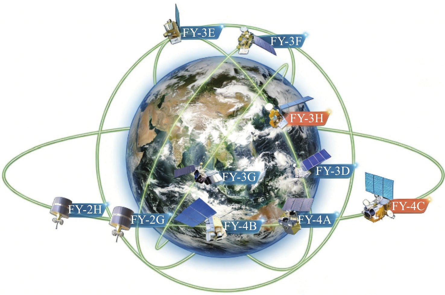
Abstract: This paper systematically presents the comprehensive progress of the FengYun (FY) meteorological satellite integrated observation system during 2024–2026. With the successful launched of FY-3H polar-orbiting satellite and FY-4C geostationary satellite, the FY constellation has improved the polar four-orbit networking and geostationary two-satellite coordinated configuration, realizing optimized GEO-LEO satellites collaborative observation. Major breakthroughs have been made in hyperspectral detection, active microwave remote sensing, high-precision geolocation and radiometric calibration, as well as intelligent ground operation. The product system has been expanded to 85 geophysical parameters in six categories, with significant innovations in multi-source data fusion, physical-constrained retrieval and AI-driven algorithms. FY satellite data have been widely applied in weather forecasting, severe disaster monitoring, climate change assessment, ecological environment protection, space weather services and key industrial fields. Up to now, FY satellites have provided data and application services to 139 countries and regions, conducted international emergency support for disaster prevention and mitigation, and deeply participated in global meteorological governance. This paper summarizes the technological advances, application benefits and global contributions of the FY system, and prospects its future development in higher precision, intelligence and global services.
-
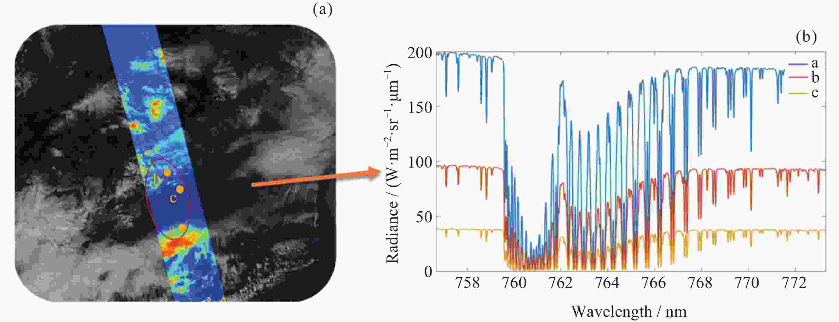
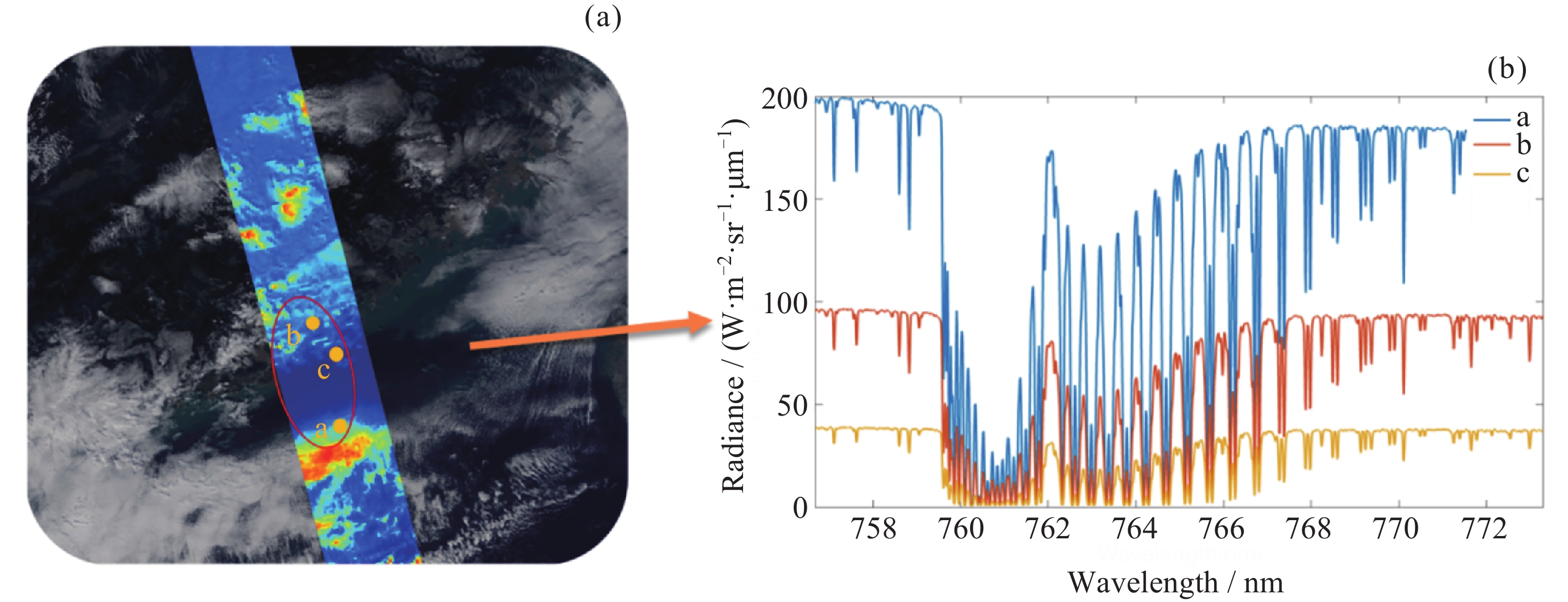
Figure 1. Refined spectra of different detection targets for GAS-II (a-Cloud area, b-Land, c-Ocean). (a) Regional monitoring data acquired by GAS-II on global orbits. (b) High-resolution spectra (758–772 nm) for cloud, land, and ocean targets
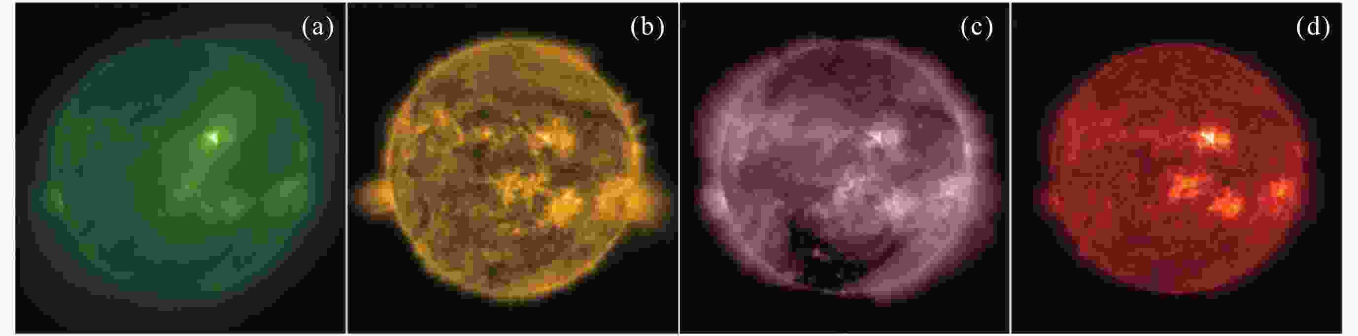
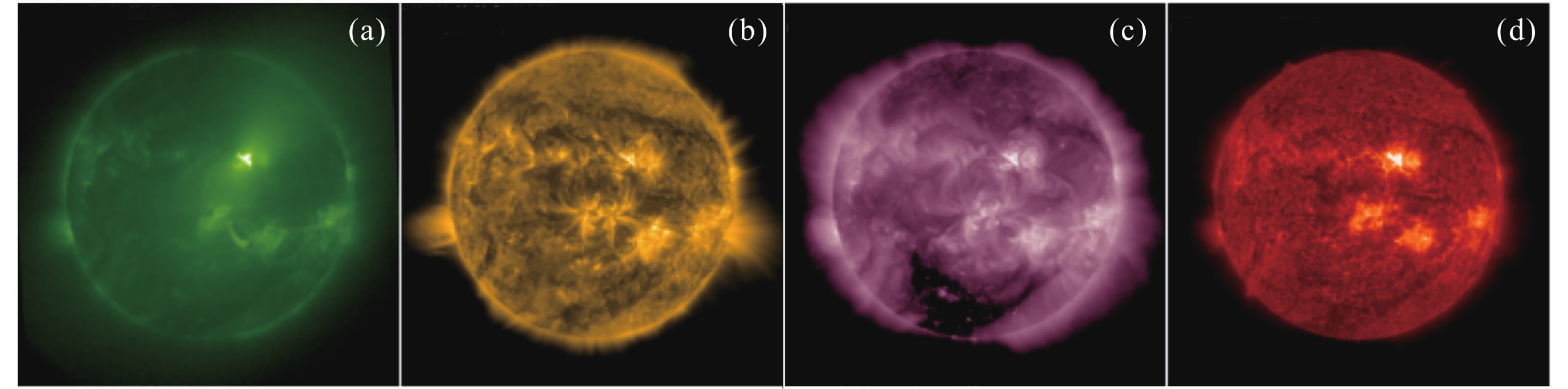
Figure 2. X1.1 class solar flare observed by FY4 C/SUVI at wavelengths of 94 Å (a), 171 Å (b), 211 Å (c) and 304 Å (d) at 20:50 UTC on 30 June 2026
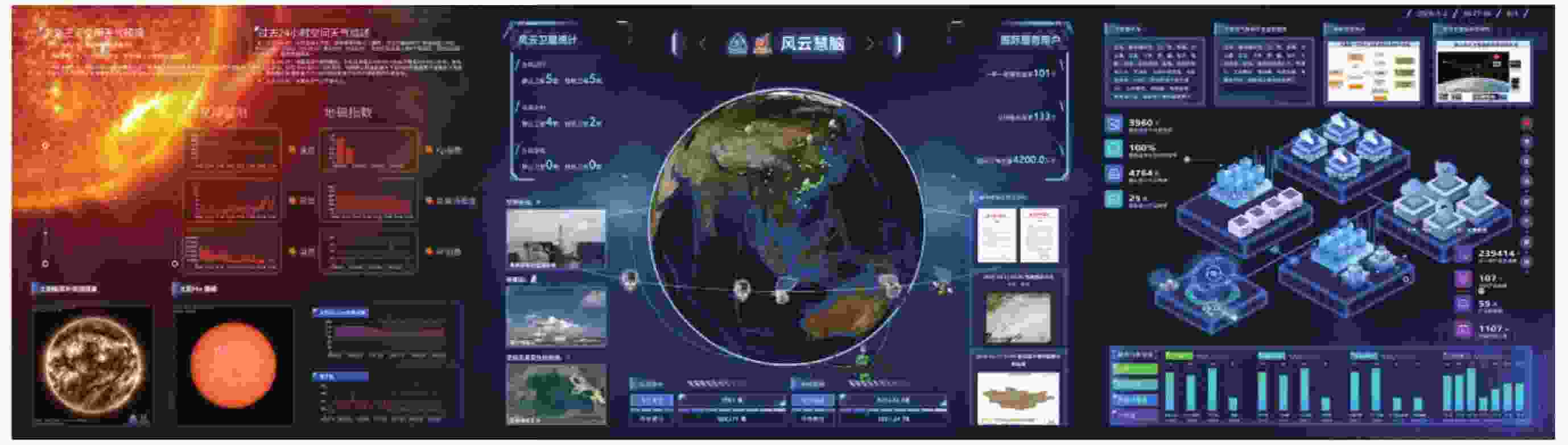
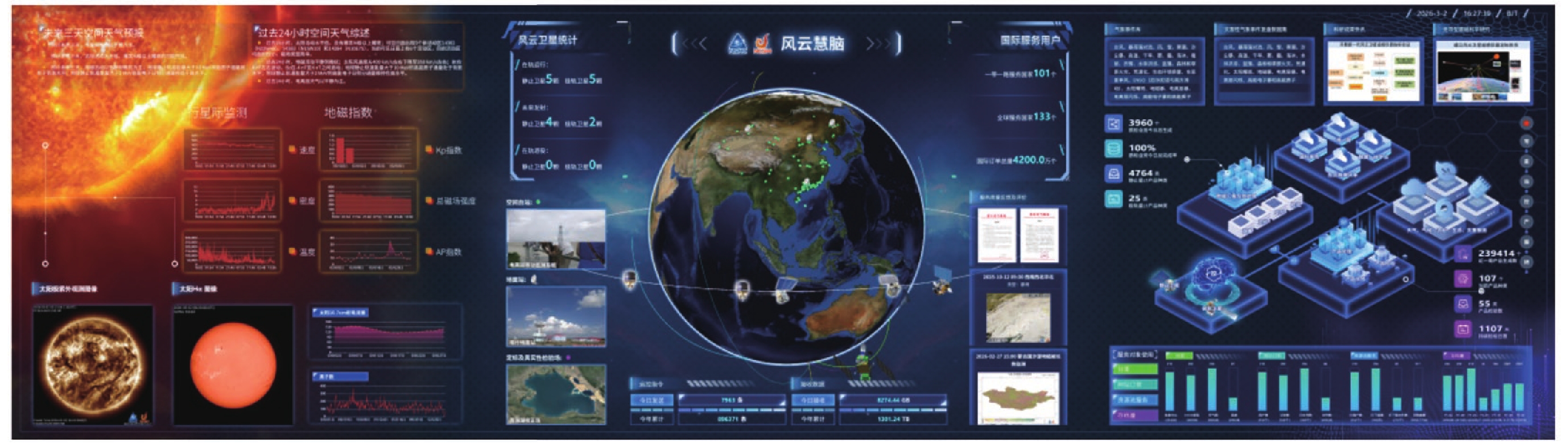
Figure 4. FengYun smart brain: an intelligent command and decision platform for multi-satellite integrated operation control, satellite-ground monitoring, data quality evaluation, and application services
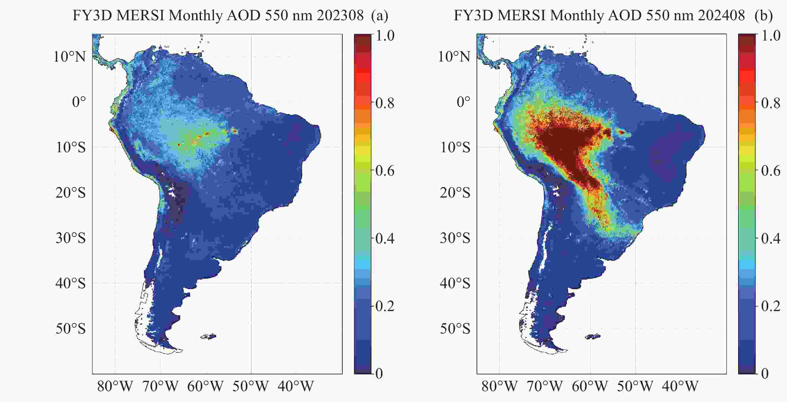
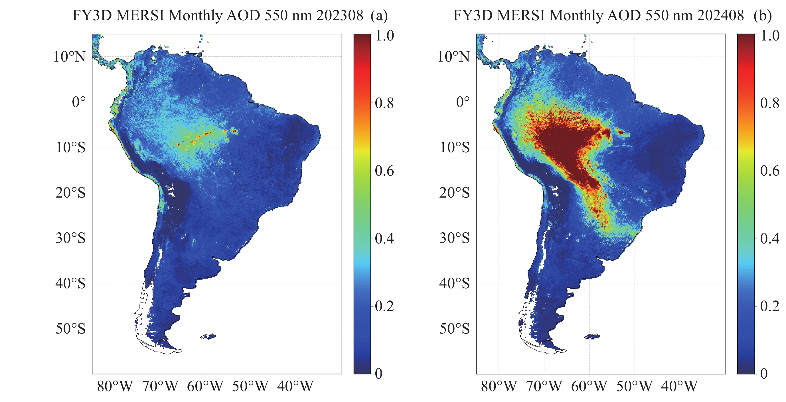
Figure 5. Spatial distribution of monthly average AOD retrievals obtained from FY-3D/MERSI-II during Aug. 2023(a) and Aug. 2024(b)
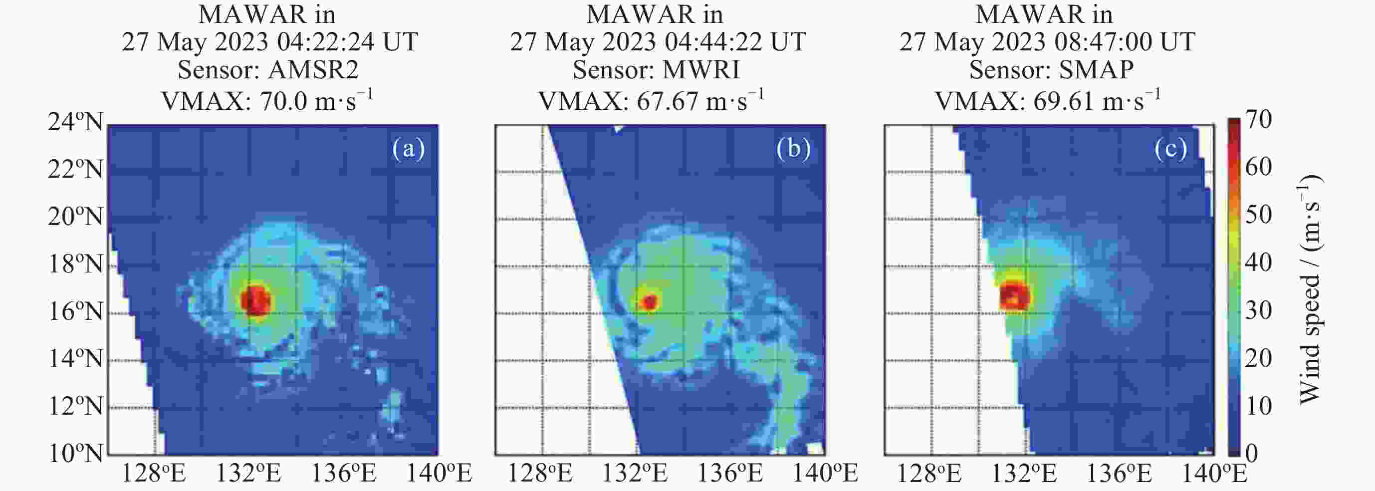
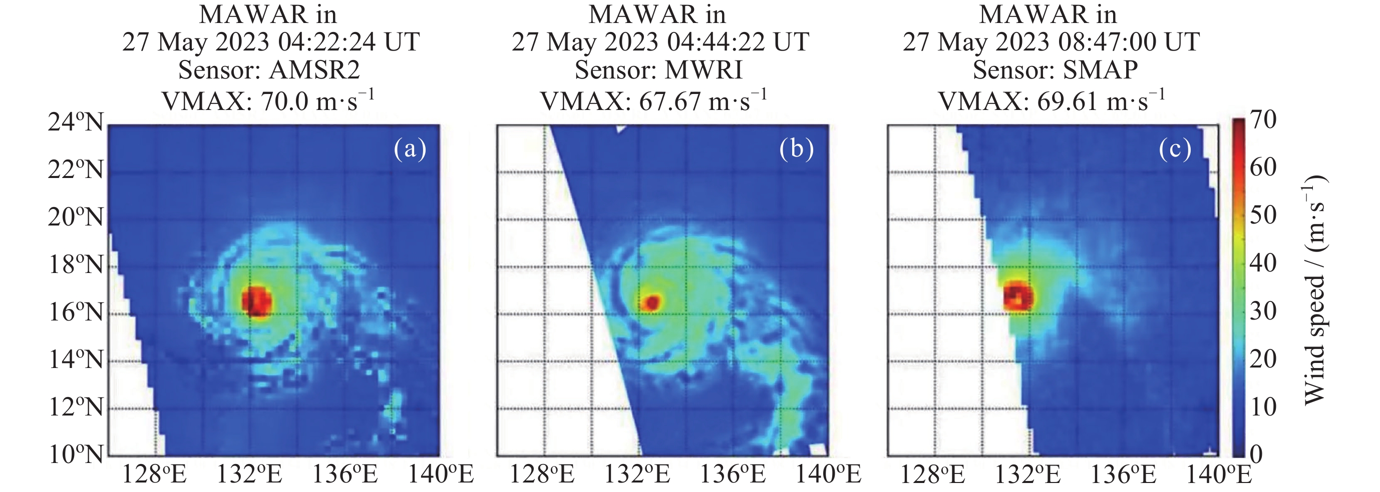
Figure 6. Spatial distributions of the AMSR2 all-weather SSWS (a), MWRI SSWS retrieved by the LWDNN (b), and SMAP SSWS (c) for typhoon MAWAR
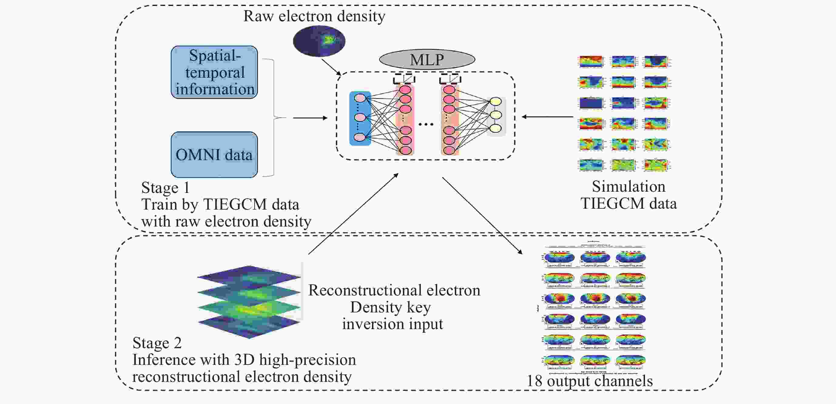
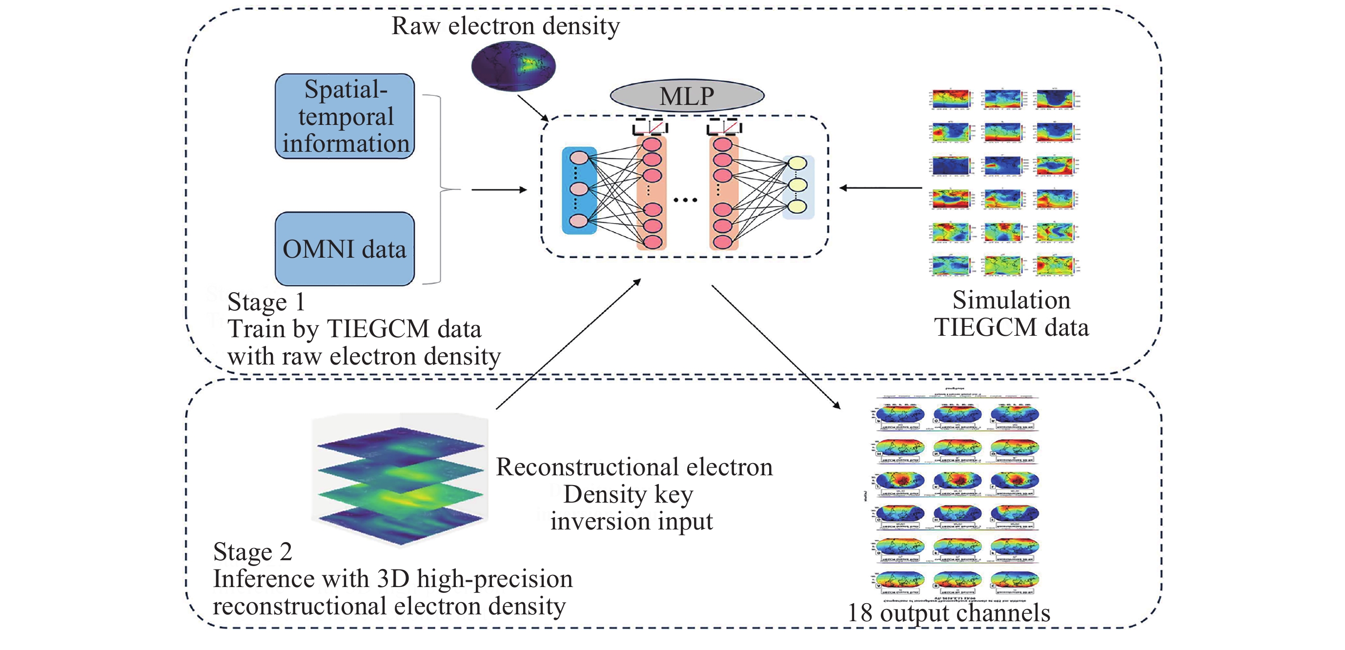
Figure 7. Architecture of the TIEGCM-based inversion model for end-to-end mapping from observable data to latent ionosphere-thermosphere state variables
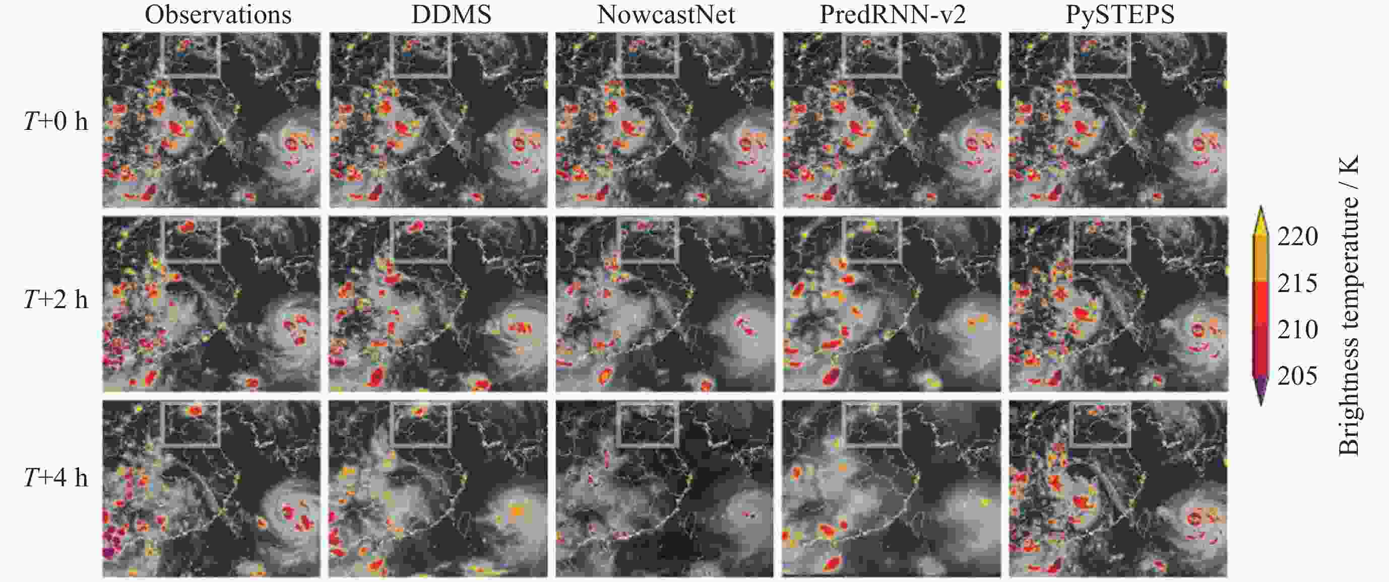
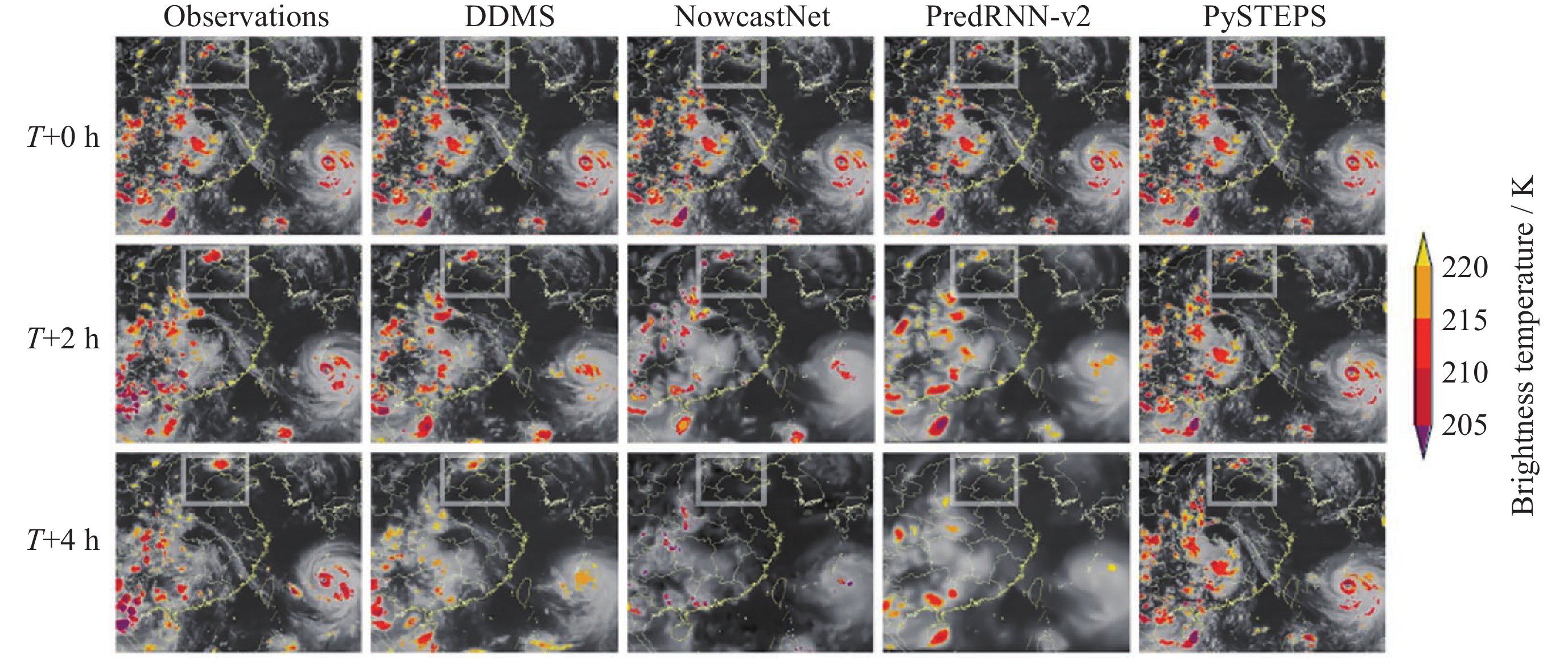
Figure 8. 4 h lead time nowcasting comparison of multiple models for the severe convective extreme rainstorm event in the Beijing-Tianjin-Hebei region on 29 July 2023 associated with Typhoon Doksuri
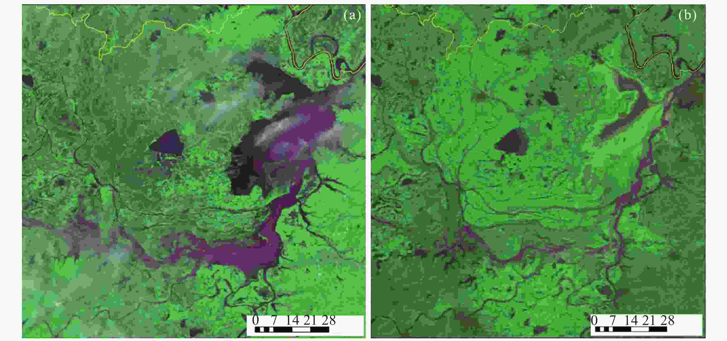
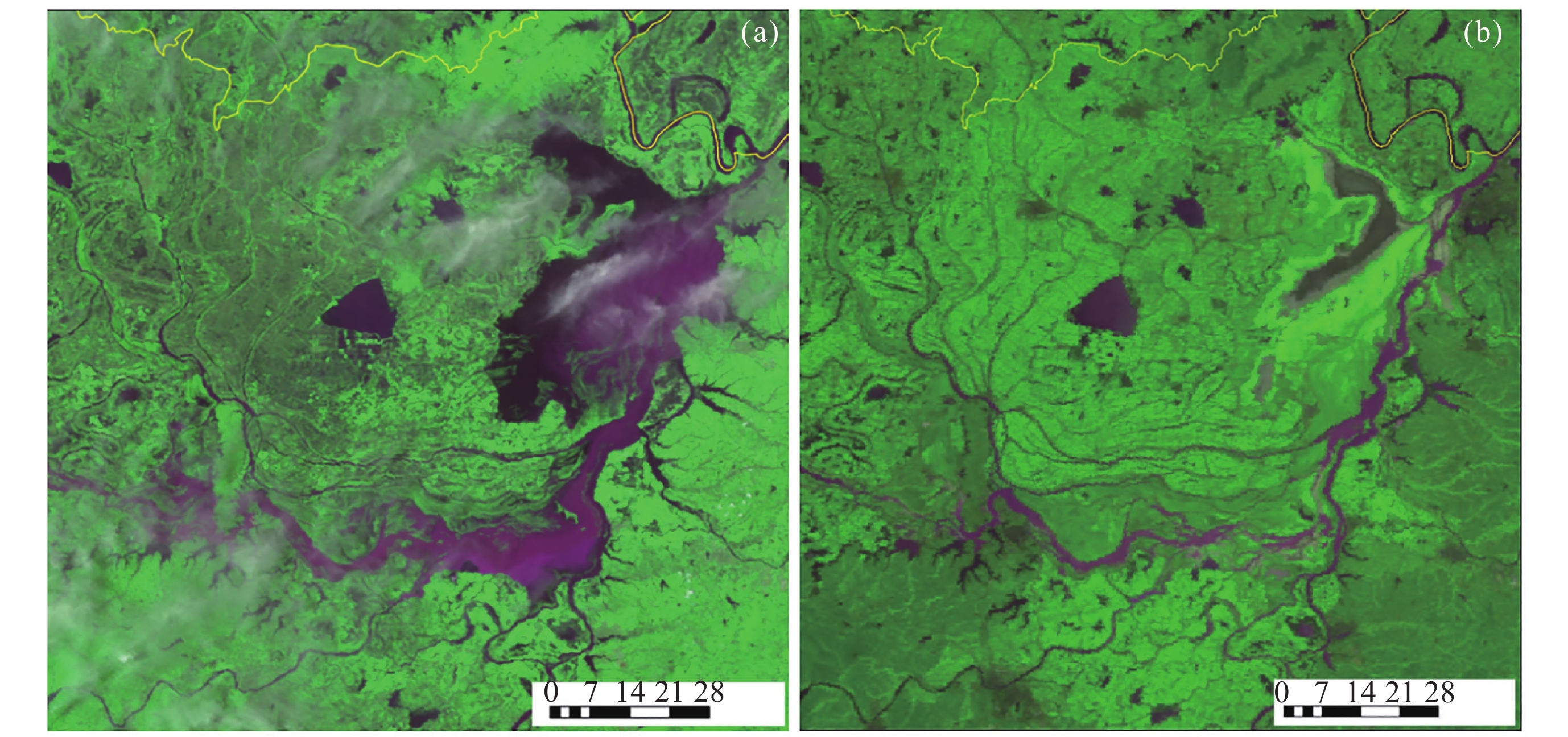
Figure 11. Water reduction of the Dongting Lake induced by high temperature and drought monitored by FY-3D on 14 June (a) and 5 September (b) in 2022
Table 1. FY-3H remote sensing instruments
Instruments full name Acronym Status 1 Medium Resolution Spectral Imager-III MERSI-III Inherited 2 Hyperspectral Infrared Atmospheric Sounder-II HIRAS-II 3 Micro-Wave Temperature Sounder-III MWTS-III 4 Micro-Wave Humidity Sounder-II MWHS-II 5 Micro-Wave Radiation Imager-II MWRI-II 6 GNSS Radio Occultation Sounder-II GNOS-II 7 Ionospheric PhotoMeter-II IPM-II 8 Greenhouse-gases Absorption Spectrometer-II GAS-II New 9 Wide-field Auroral Imager-II WAI-II Improved  下载: 导出CSV
Table 2. Remote sensing instruments on FY-4C
Instrument Acronym Status 1 Advanced Geostationary Radiation Imager AGRI Improved 2 Geostationary Interferometric Infrared Sounder GIIRS 3 Lightning Mapping Imager LMI 4 Solar extreme-UltraViolet Imager SUVI New 5 Multi-band ionosphere Ultraviolet Spectral Imager MUSI 6 Solar X-ray and extreme-Ultraviolet Spectral fluxmeter SXUS
下载: 导出CSV
-
[1] 王劲松, 郭强, 徐娜. 风云气象卫星效能体系概论与实践[M]. 北京: 气象出版社, 2025WANG Jinsong, GUO Qiang, XU Na. Theory and practice of the effectiveness-evaluation system for FengYun meteorological satellites[M]. Beijing: China Meteorological Press, 2025 [2] CHEN Lin, XU Na, WANG Jinsong, et al. FengYun satellites: from observations to quantitative applications[J]. National Remote Sensing Bulletin, 2025, 29(6): 1462-1479 doi: 10.11834/jrs.20254459 [3] WANG Jinsong, GUAN Min, YUAN Muye, et al. Innovation and application of FengYun meteorological satellite observation system[J]. Satellite Application, 2025(9): 6-14 doi: 10.3969/j.issn.1674-9030.2025.09.003 [4] ZHANG Peng, LI Rui, ZHAO Kun, et al. Development of an integrated meteorological observation system in China[J]. Acta Meteorologica Sinica, 2025, 83(3): 729-760 doi: 10.11676/qxxb2025.20240193 [5] GUAN Min, ZHANG Yong, LI Yun, et al. Current development and future trends of FengYun meteorological satellites[J]. Advances in Earth Science, 2025, 40(2): 138-154 doi: 10.11867/j.issn.1001-8166.2025.009 [6] National Satellite Meteorological Center. FengYun Series Satellites[EB/OL]. [2026-05-08]. http://www.nsmc.org.cn/nsmc/en/satellite/index.html [7] WANG Jiachen, WANG Jing, LIU Chengbao, et al. Orbit motion compensation modeling and simulation analysis for FY-4 geostationary meteorological satellite[J]. Geomatics and Information Science of Wuhan University, 2024, 49(10): 1879-1890 doi: 10.13203/j.whugis20220314 [8] SHANG Jian, LIU Chengbao, YANG Lei, et al. Resident and navigation accuracy analysis of interferometric infrared sounder onboard FY-4 satellite[J]. Journal of Telemetry, Tracking and Command, 2024, 45(6): 1-10 doi: 10.12347/j.ycyk.20240414001 [9] LU Wenqiang, HU Xiuqing, HUANG Yong, et al. Analysis of FY-3D satellite attitude and orbit accuracy and its influence on geolocation[J]. Geomatics and Information Science of Wuhan University, 2024, 49(2): 256-263 doi: 10.13203/j.whugis20210403 [10] WANG Jiachen, SHANG Jian, YANG Lei, et al. Geolocation of the tangent point and tangent height correction for spaceborne ultraviolet limb sounder[J]. Optics and Precision Engineering, 2026, 34(2): 179-190 doi: 10.37188/OPE.20263402.0179 [11] XIE X X, GUO Y, HE J Y, et al. Calibration of microwave humidity sounder-II onboard FengYun-3F in pre/postlaunch phases[J]. IEEE Transactions on Geoscience and Remote Sensing, 2024, 62: 5302009 doi: 10.1109/TGRS.2024.3451527 [12] WANG Q, WANG Y M, XU N, et al. Preflight spectral calibration of the ozone monitoring suite-nadir on FengYun 3F Satellite[J]. Remote Sensing, 2024, 16(9): 1538 doi: 10.3390/rs16091538 [13] SHANG J, SHI H Q, YUAN M, et al. Satellite-ground integrated external calibration of the WindRAD scatterometer onboard FY-3E satellite[J]. IEEE Transactions on Geoscience and Remote Sensing, 2025, 63: 5100910 doi: 10.1109/TGRS.2025.3526834 [14] MIAO S X, SUN K M, HU X Q, et al. On-orbit radiometric performance assessment of FY-3F MERSI-III: a cross-platform intercomparison approach based on global pseudo-invariant pixels[J]. IEEE Journal of Selected Topics in Applied Earth Observations and Remote Sensing, 2025, 18: 21514-21531 doi: 10.1109/JSTARS.2025.3597457 [15] CHEN B Y, WU A Q, HUI W, et al. Radiometric calibration using artificial intelligence: constituting uniform observing systems for infrared satellites[J]. IEEE Transactions on Geoscience and Remote Sensing, 2025, 63: 5001616 doi: 10.1109/TGRS.2025.3534794 [16] LIN H, LI J, MIN M, et al. CLANN: cloud amount neural network for estimating 3D cloud from geostationary satellite imager[J]. Remote Sensing of Environment, 2025, 318: 114600 doi: 10.1016/j.rse.2025.114600 [17] YANG J Y, QIU Z F, ZHAO D Z, et al. CACM-Net++: FY-4B AGRI day and night cloud mask algorithm modeling[J]. IEEE Transactions on Geoscience and Remote Sensing, 2026, 64: 4104612 doi: 10.1109/TGRS.2026.3670024 [18] GONG X Y, LI Z L, LI J, et al. Cloud-cleared radiances from collocated observations of hyperspectral IR sounder and advanced imager onboard the same geostationary platform[J]. IEEE Transactions on Geoscience and Remote Sensing, 2024, 62: 5531418 doi: 10.1109/TGRS.2024.3458093 [19] WU Y H, LI B, LI J, et al. Enhancing nighttime cloud detection for moderate resolution imagers using a transformer based deep learning network[J]. Remote Sensing of Environment, 2026, 332: 115067 doi: 10.1016/j.rse.2025.115067 [20] SI Y D, CHEN L, WANG Y Y, et al. An improved aerosol retrieval algorithm based on nonlinear surface model from FY-3D/MERSI-II remote sensing data[J]. IEEE Transactions on Geoscience and Remote Sensing, 2024, 62: 4103017 doi: 10.1109/TGRS.2024.3367883 [21] SI Y D, WANG L, CHEN L, et al. Coupling hourly land surface models with spatiotemporal variability characteristics: a study on FY-4B/AGRI land aerosol retrieval algorithm[J]. IEEE Transactions on Geoscience and Remote Sensing, 2025, 63: 4107820 doi: 10.1109/TGRS.2025.3591646 [22] SI Y D, GAO L, CHEN L, et al. An adaptive dark-target algorithm for retrieving land AOD applied to FY-4B/AGRI data[J]. IEEE Journal of Selected Topics in Applied Earth Observations and Remote Sensing, 2024, 17: 14035-14049 doi: 10.1109/JSTARS.2024.3408251 [23] SONG P L, LIU X Z, SUN L, et al. Soil moisture estimation based on FY-3E backscattering data for enhanced daily coverage to SMAP observations in the dawn-dusk orbit[J]. Remote Sensing of Environment, 2024, 309: 114209 doi: 10.1016/j.rse.2024.114209 [24] XU R H, WANG X, HU Y H, et al. Estimation of all-sky gridded diurnal near-surface air temperatures at regional scale from FY-4B measurements[J]. IEEE Journal of Selected Topics in Applied Earth Observations and Remote Sensing, 2025, 18: 1288-1301 doi: 10.1109/JSTARS.2024.3506857 [25] ZHANG Y K, XU N, ZHAI X C, et al. A lightweight deep neural network for sea surface wind speed retrievals from the FY-3D/MWRI[J]. IEEE Transactions on Geoscience and Remote Sensing, 2025, 63: 4102515 doi: 10.1109/TGRS.2025.3539992 [26] ZHAI X C, TIAN S R, SHANG J, et al. Intercomparison of Ku- and C-band backscatter feature parameters for arctic sea ice using spaceborne FengYun-3E WindRAD scatterometer[J]. IEEE Transactions on Geoscience and Remote Sensing, 2025, 63: 4214824 doi: 10.1109/TGRS.2025.3632199 [27] CHEN Z, ZHANG J L, WANG J S, et al. A TIEGCM-based inversion model for ionosphere-thermosphere parameters driven by three-dimensional electron density[J]. Science Advances, 2026, 12(16): eaea2406 doi: 10.1126/sciadv.aea2406 [28] ZHANG J L, ZHANG J X, CHEN Z, et al. Deep learning-based vertical decomposition of ionospheric TEC into layered electron density profiles[J]. Atmosphere, 2025, 16(5): 598 doi: 10.3390/atmos16050598 [29] DAI K, LI X T, FANG J Y, et al. Four-hour thunderstorm nowcasting using a deep diffusion model for satellite data[J]. Proceedings of the National Academy of Sciences of the United States of America, 2025, 122(51): e2517520122 doi: 10.1073/pnas.2517520122 [30] LIU N Q, JIANG J Y, MAO D Y, et al. Artificial intelligence-based precipitation estimation method using FengYun-4B satellite data[J]. Remote Sensing, 2024, 16(21): 4076 doi: 10.3390/rs16214076 [31] XU A, XUE H L, WU R H, et al. An observation of the trapped lee waves using FengYun-4 satellite images and a U-Net network[J]. Geophysical Research Letters, 2025, 52(7): e2024GL113858 doi: 10.1029/2024GL113858 [32] LEI Lili, WENG Fuzhong, DUAN Wansuo, et al. Overview and prospect of data assimilation in numerical weather prediction[J]. Acta Meteorologica Sinica, 2025, 83(3): 503-535 doi: 10.11676/qxxb2025.20240167 [33] YIN R Y, HAN W. Impact of targeted sounding observations from FY-4B GIIRS on two super typhoon forecasts in 2024[J]. IEEE Geoscience and Remote Sensing Letters, 2025, 22: 5500805 doi: 10.1109/lgrs.2024.3516004 [34] XIANG Chunyi, DONG Lin, LIU Da, et al. Thermodynamic and dynamic mechanism of maintenance of typhoon Doksuri remnant vortex after its landfall in 2023[J]. Meteorological Monthly, 2024, 50(11): 1289-1305 doi: 10.7519/j.issn.1000-0526.2024.081901 [35] NIU Ning, REN Suling, QIN Danyu. Application of FY-4A satellite data in monitoring of the cold wave from 6 to 8 January 2021[J]. Meteorological Monthly, 2024, 50(6): 661-674 doi: 10.7519/j.issn.1000-0526.2024.032601 [36] NIU N, REN S L, MAO D Y, et al. The application of meteorological satellite products in the extreme sea-effect snowstorm monitoring in East Asia[J]. Journal of the Meteorological Society of Japan. Ser. Ⅱ, 2024, 102(6): 633-653 doi: 10.2151/jmsj.2024-033 [37] TAN Juan, QIAN Chuanhai, HUANG Bin, et al. The current status and future perspectives of sea fog monitoring and forecasting in China[J]. Advances in Meteorological Science and Technology, 2024, 14(2): 17-23,32 doi: 10.3969/j.issn.2095-1973.2024.02.003 [38] LI Y X, ZHU S Y, ZHANG G X, et al. Reconstruction of hourly FY-4A AGRI land surface temperature under cloud-covered conditions using a hybrid method combining spatial and temporal information[J]. Remote Sensing, 2024, 16(10): 1777 doi: 10.3390/rs16101777 [39] LUO Yumei, ZHU Shanyou, LI Yueli, et al. Analyzing the influence of missing periods on the time dimensional reconstruction of summer land surface temperature in the Heihe River Basin using FY-4A AGRI data[J]. Journal of Geo-Information Science, 2024, 26(3): 709-724 doi: 10.12082/dqxxkx.2024.230339 [40] LIU Yunyun, ZHANG Daquan, SONG Lianchun, et al. Revision and application of the western Pacific subtropical high indices[J]. Acta Meteorologica Sinica, 2024, 82(6): 801-815 doi: 10.11676/qxxb2024.20240009 [41] WANG Jinsong, REN Suling, YANG Bingyun, et al. Current status and future prospects of FengYun meteorological satellite remote sensing operational application[J]. Advances in Meteorological Science and Technology, 2026, 16(1): 11-25 doi: 10.3969/j.issn.2095-1973.2026.01.002 [42] GAO L, ZHANG Q Q, WANG Y P, et al. A review on the Chinese FengYun series meteorological satellites for atmospheric composition monitoring[J]. Bulletin of the American Meteorological Society, 2026, 107(5): E1092-E1108 doi: 10.1175/BAMS-D-25-0003.1 [43] XU J, WANG Y P, CHEN L et al. First total ozone column observations from the Ozone Monitoring Suite-Nadir (OMS-N) onboard China’s FengYun-3F satellite[J]. Science China Earth Sciences, 2025, 68(11): 3665-3683 doi: 10.1007/s11430-025-1686-0 [44] LIU Y, CHEN J, SHI Y S, et al. Global Emissions Inventory from Open Biomass Burning (GEIOBB): utilizing FengYun-3D global fire spot monitoring data[J]. Earth System Science Data, 2024, 16(8): 3495-3515 doi: 10.5194/essd-16-3495-2024 [45] ZHOU X J, WANG T, ZHENG W, et al. Reconstruction of fine-spatial-resolution FY-3D-Based vegetation indices to achieve farmland-scale winter wheat yield estimation via fusion with sentinel-2 data[J]. Remote Sensing, 2024, 16(22): 4143 doi: 10.3390/rs16224143 [46] GUAN Min, ZHANG Yong, XIE Lizi, et al. Research on the contribution of Fenyun meteorological satellite remote sensing applications to national economic development[J]. Meteorological Soft Sciences, 2025, 150(4): 61-66 -
-

 下载:
下载:

计量
- 文章访问数: 729
- HTML全文浏览量: 400
- PDF下载量: 18
-
被引次数:
0(来源:Crossref)
0(来源:其他)

