| Citation: | GUO Huadong, DOU Changyong, LIANG Dong, JIANG Nijun, TANG Yunwei, MA Wenyong. SDGSAT-1: Capabilities for Monitoring and Evaluating SDG Indicators. Chinese Journal of Space Science, 2024, 44(4): 677-686 doi: 10.11728/cjss2024.04.2024-yg15

|

| [1] |
United Nations. Sustainable Development Goals Progress Chart 2023[R]. New York: United Nations, 2023
|
| [2] |
GUO H D, DOU C Y, CHEN H Y, et al. SDGSAT-1: the world’s first scientific satellite for sustainable development goals[J]. Science Bulletin, 2023, 68(1): 34-38 doi: 10.1016/j.scib.2022.12.014
|
| [3] |
ESA. Earth Observation for SDG: Compendium of Earth Observation Contributions to the SDG Targets and Indicators[R]. Harwell: ESA, 2020
|
| [4] |
United Nations. The “Space2030” Agenda: Space As a Driver of Sustainable Development[R]. New York: United Nations, 2021
|
| [5] |
GUO H D, CHEN H Y, CHEN L F, et al. Progress on CASEarth satellite development[J]. Chinese Journal of Space Science, 2020, 40(5): 707-717 doi: 10.11728/cjss2020.05.707
|
| [6] |
GUO H, DOU C, CHEN H, et al. Progress of SDGSAT-1 mission[J]. Chinese Journal of Space Science, 2022, 42(4): 44-48
|
| [7] |
CUI Z Z, MA C, ZHANG H, et al. Vicarious radiometric calibration of the multispectral imager onboard SDGSAT-1 over the Dunhuang calibration site, China[J]. Remote Sensing, 2023, 15(10): 2578 doi: 10.3390/rs15102578
|
| [8] |
CBAS. SDGSAT-1 Data Users Handbook[EB/OL]. Beijing: CBAS. [2024-04-26]. https://www.sdgsat.ac.cn/userGuide/document
|
| [9] |
HU Y H, LI X M, DOU C Y, et al. Absolute radiometric calibration evaluation of the thermal infrared spectrometer onboard SDGSAT-1[J]. International Journal of Digital Earth, 2023, 16(2): 4492-4511 doi: 10.1080/17538947.2023.2274418
|
| [10] |
QI L T, LI L Y, NI X Y, et al. On-orbit spatial quality evaluation of SDGSAT-1 thermal infrared spectrometer[J]. IEEE Geoscience and Remote Sensing Letters, 2022, 19: 7507505
|
| [11] |
YANG L, LI X Y, JIANG L Y, et al. Resolution-normalizing image stitching for long-linear-array and wide-swath whiskbroom payloads[J]. IEEE Geoscience and Remote Sensing Letters, 2022, 19: 7507705
|
| [12] |
QI L T, ZHANG R G, HU Z Y, et al. Fast thermal infrared image restoration method based on on-orbit invariant modulation transfer function[J]. IEEE Transactions on Geoscience and Remote Sensing, 2024, 62: 5001015
|
| [13] |
ZHONG X, ZHAO L H, REN P, et al. Land surface emissivity retrieval from SDGSAT-1: comparison of LSE products with different spatial resolutions[J]. International Journal of Digital Earth, 2024, 17(1): 2297940 doi: 10.1080/17538947.2023.2297940
|
| [14] |
YAN L, HU Y H, DOU C Y, et al. Radiometric calibration of SDGSAT-1 nighttime light payload[J]. IEEE Transactions on Geoscience and Remote Sensing, 2024, 62: 1000715
|
| [15] |
LIU S Y, WANG C X, CHEN Z Q, et al. Efficacy of the SDGSAT-1 glimmer imagery in measuring sustainable development goal indicators 7.1. 1, 11.5. 2, and target 7.3[J]. Remote Sensing of Environment, 2024, 305: 114079 doi: 10.1016/j.rse.2024.114079
|
| [16] |
WANG N, HU Y H, LI X M, et al. Enhancing SDGSAT-1 night light images using a panchromatic guidance denoising algorithm[J]. International Journal of Applied Earth Observation and Geoinformation, 2024, 128: 103748 doi: 10.1016/j.jag.2024.103748
|
| [17] |
ZHANG D G, CHENG B, SHI L, et al. A destriping algorithm for SDGSAT-1 nighttime light images based on anomaly detection and spectral similarity restoration[J]. Remote Sensing, 2022, 14(21): 5544 doi: 10.3390/rs14215544
|
| [18] |
LI H, JING L H, DOU C Y, et al. A comprehensive assessment of the pansharpening of the nighttime light imagery of the glimmer imager of the sustainable development science satellite 1[J]. Remote Sensing, 2024, 16(2): 245 doi: 10.3390/rs16020245
|
| [19] |
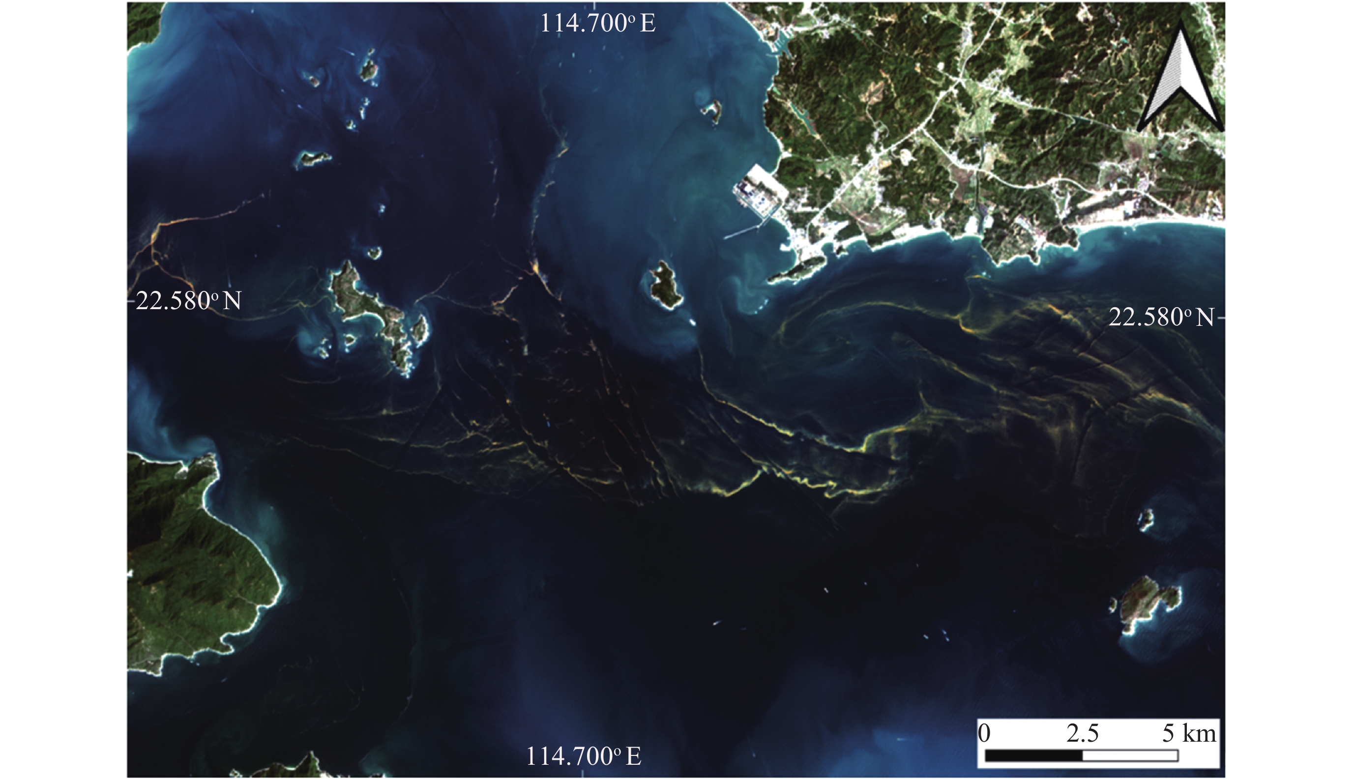
WU J, YE H B, LIU Y M, et al. The evaluation of MII/SDGSAT-1 in red tide detection along the guangdong middle coast[J]. IEEE Geoscience and Remote Sensing Letters, 2024, 21: 1500305
|
| [20] |
HOU Y Z, XING Q G, ZHENG X Y, et al. Monitoring suspended sediment concentration in the Yellow River estuary and its vicinity waters on the basis of SDGSAT-1 multispectral imager[J]. Water, 2023, 15(19): 3522 doi: 10.3390/w15193522
|
| [21] |
SANG R D, WANG Y O, ZHANG F F, et al. A novel water optical types framework for Chinese inland waters with the application of multitype satellite sensor[J]. International Journal of Digital Earth, 2024, 17(1): 2327834 doi: 10.1080/17538947.2024.2327834
|
| [22] |
HU X K, LI J G, SUN Y, et al. Retrieval of total suspended matter concentration based on the iterative analysis of multiple equations: a case study of a lake Taihu image from the first sustainable development goals science satellite’s multispectral imager for inshore[J]. Remote Sensing, 2024, 16(8): 1385 doi: 10.3390/rs16081385
|
| [23] |
HUANG W W, JIAO J J, ZHAO L X, et al. Thermal discharge temperature retrieval and monitoring of NPPs based on SDGSAT-1 images[J]. Remote Sensing, 2023, 15(9): 2298 doi: 10.3390/rs15092298
|
| [24] |
WANG D C, XIE Y M, MA C H, et al. Identification of industrial heat source production areas based on SDGSAT-1 thermal infrared imager[J]. Applied Sciences, 2024, 14(6): 2450 doi: 10.3390/app14062450
|
| [25] |
LEVIN N. Using night lights from space to assess areas impacted by the 2023 turkey earthquake[J]. Remote Sensing, 2023, 15(8): 2120 doi: 10.3390/rs15082120
|
| [26] |
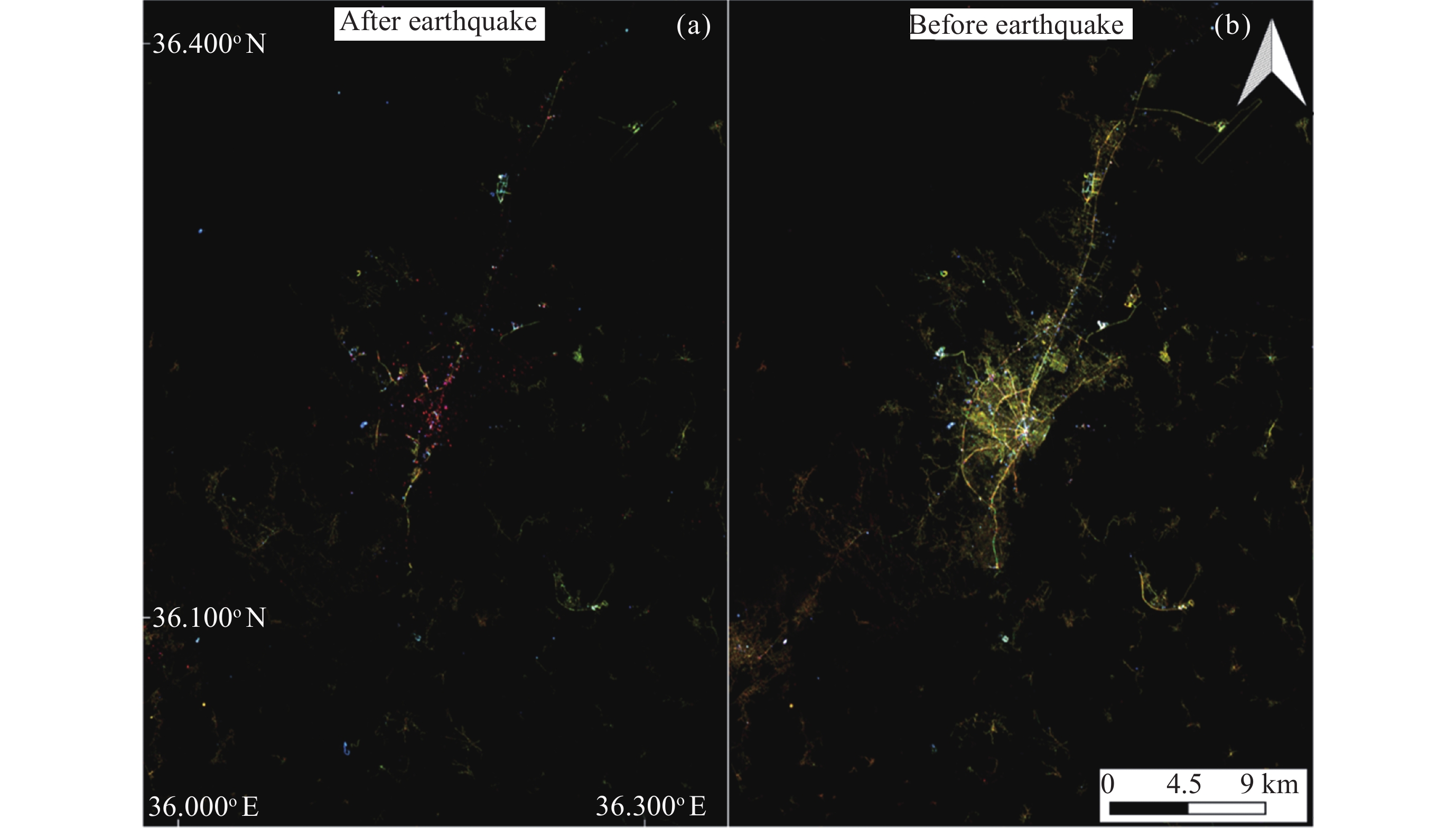
YU B, CHEN F, WANG N, et al. Assessing changes in nighttime lighting in the aftermath of the Turkey-Syria earthquake using SDGSAT-1 satellite data[J]. The Innovation, 2023, 4(3): 100419 doi: 10.1016/j.xinn.2023.100419
|
| [27] |
UNOSAT. Night-time light loss assessment in Derna & Al Bayda (Libya) using night-time light imagery[EB/OL]. Geneva: UNOSAT. [2024-04-26]. https://unosat.org/products/3678
|
| [28] |
UNOSAT. Power outage assessment in Sudan using night-time light imagery[EB/OL]. Geneva: UNOSAT. [2024-04-26]. https://unosat.org/products/3625
|
| [29] |
IRDR. Analysis of Gansu Jishishan earthquake based on nighttime light[EB/OL]. Geneva: UNDRR. [2024-04-26]. https://www.preventionweb.net/publication/analysis-gansu-jishishan-earthquake-based-nighttime-light
|
| [30] |
JIA M M, ZENG H H, CHEN Z Q, et al. Nighttime light in China’s coastal zone: the type classification approach using SDGSAT-1 Glimmer Imager[J]. Remote Sensing of Environment, 2024, 305: 114104 doi: 10.1016/j.rse.2024.114104
|
| [31] |
GUO B Y, HU D Y, ZHENG Q M. Potentiality of SDGSAT-1 glimmer imagery to investigate the spatial variability in nighttime lights[J]. International Journal of Applied Earth Observation and Geoinformation, 2023, 119: 103313 doi: 10.1016/j.jag.2023.103313
|
| [32] |
LIN Z R, JIAO W L, LIU H C, et al. Modelling the public perception of urban public space lighting based on sdgsat-1 glimmer imagery: a case study in Beijing, China[J]. Sustainable Cities and Society, 2023, 88: 104272 doi: 10.1016/j.scs.2022.104272
|
| [33] |
LIU S M, ZHOU Y, WANG F T, et al. Lighting characteristics of public space in urban functional areas based on SDGSAT-1 glimmer imagery: a case study in Beijing, China[J]. Remote Sensing of Environment, 2024, 306: 114137 doi: 10.1016/j.rse.2024.114137
|
| [34] |
Universidad Complutense de Madrid. High-Resolution Calibrated Light Pollution Map of the Iberian Peninsula[EB/OL]. Madrid: Universidad Complutense de Madrid. [2024-04-26]. https://pmisson.users.earthengine.app/view/sdgsat-1-p-iberica
|
| [35] |
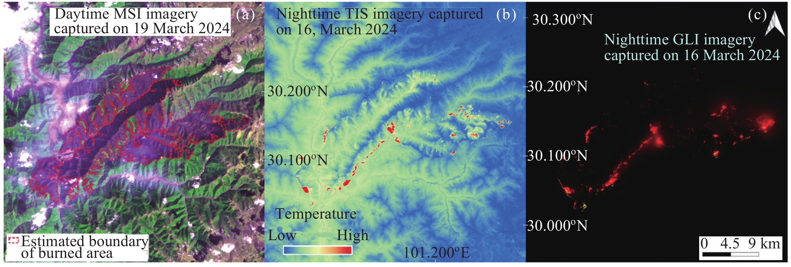
SENANDE-RIVERA M, INSUA-COSTA D, MIGUEZ-MACHO G. Spatial and temporal expansion of global wildland fire activity in response to climate change[J]. Nature Communications, 2022, 13(1): 1208 doi: 10.1038/s41467-022-28835-2
|
| [36] |
TABARI H. Climate change impact on flood and extreme precipitation increases with water availability[J]. Scientific Reports, 2020, 10(1): 13768 doi: 10.1038/s41598-020-70816-2
|
| [37] |
WUNDERLING N, WILLEIT M, DONGES J F, et al. Global warming due to loss of large ice masses and Arctic summer sea ice[J]. Nature Communications, 2020, 11(1): 5177 doi: 10.1038/s41467-020-18934-3
|
| [38] |
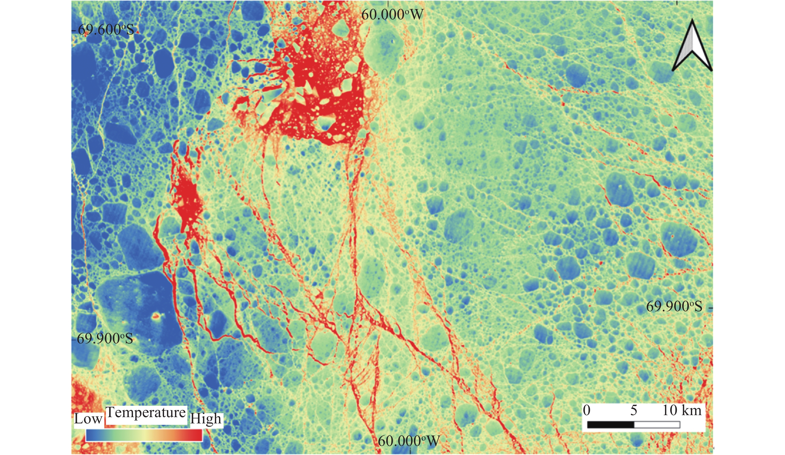
QIU Y J, LI X M, GUO H D. Spaceborne thermal infrared observations of Arctic sea ice leads at 30 m resolution[J]. The Cryosphere, 2023, 17(7): 2829-2849 doi: 10.5194/tc-17-2829-2023
|
Figures(6) / Tables(1)
Journal Introduction
ISSN 2097-7689 CN 11-1783/V
Copyright © Editorial Office of Chinese Journal of Space Science. 京ICP备08100722号
Supported by: Beijing Renhe Information Technology Co., Ltd.


 DownLoad: