2022 Vol. 42, No. 6

Review
Venus Volcano Imaging and Climate Explorer Mission
DONG Xiaolong, LIU Yang, HE Jieying, ZHANG Feng, XU Jian, ZHAO Yuyan, WANG Yu, ZHU Haotian, WANG Yongmei, WANG Wenyu, CAI Zhiming
2022, 42(6): 1047-1059. doi: 10.11728/cjss2022.06.yg33
Abstract:
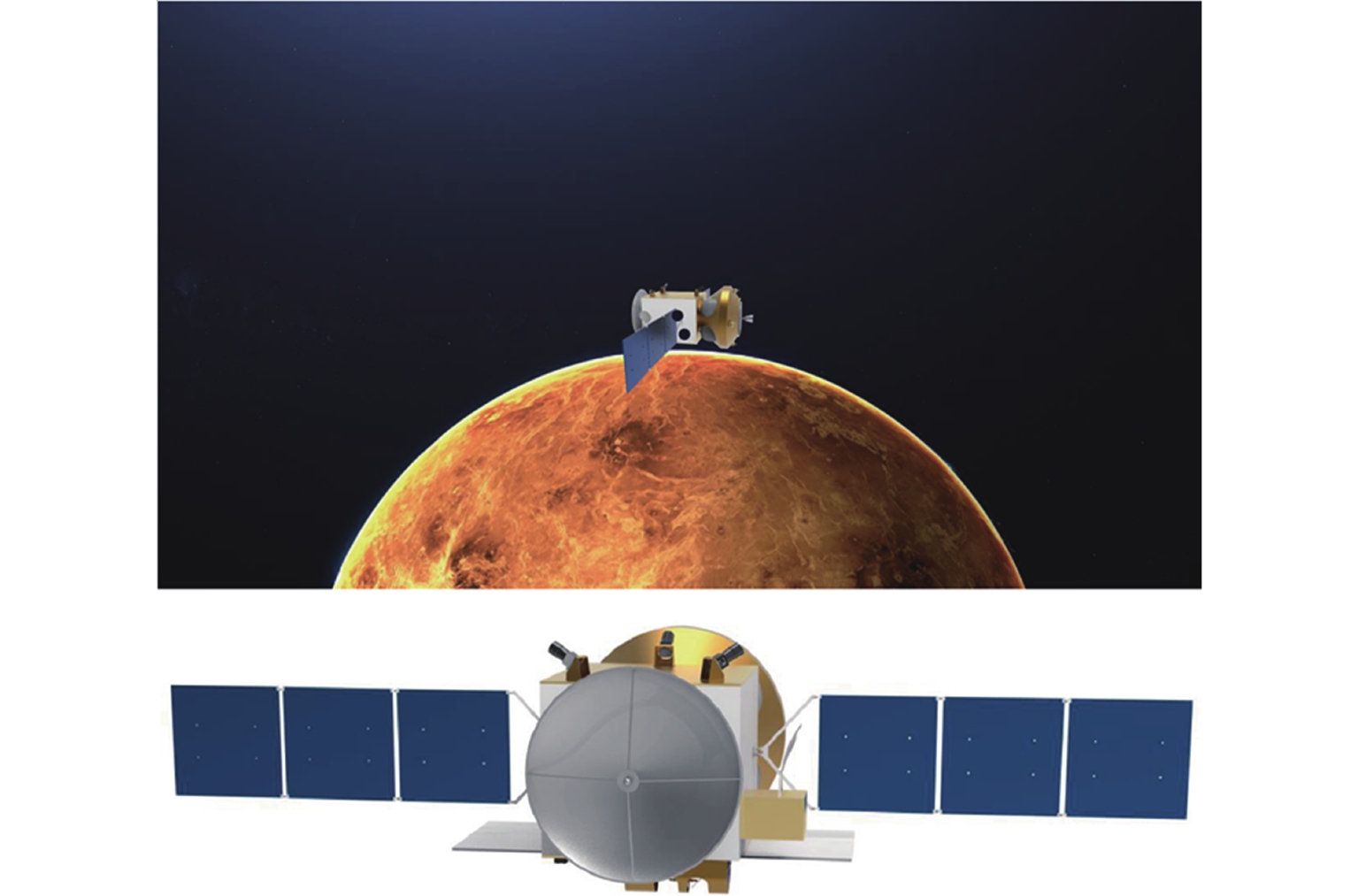
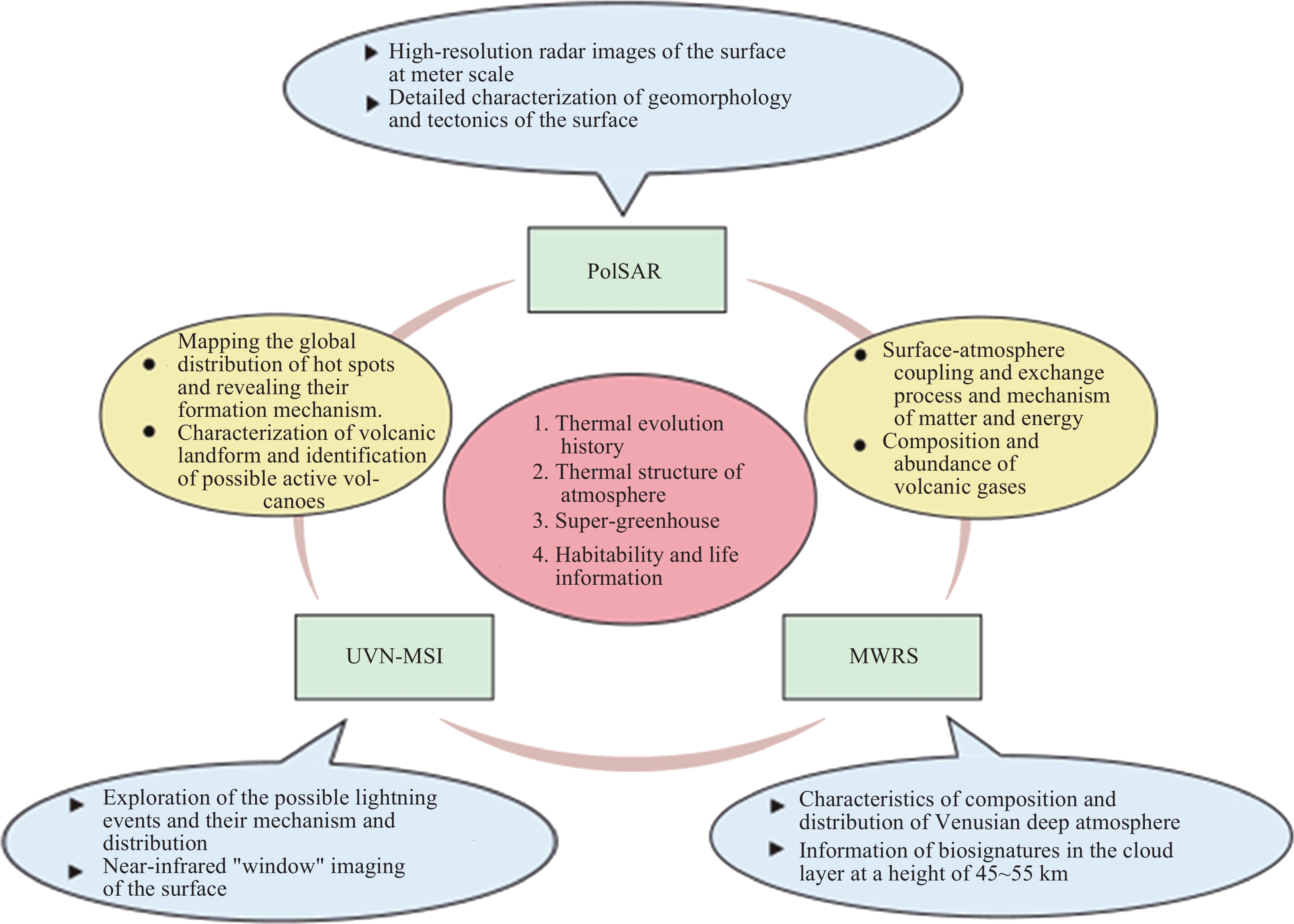
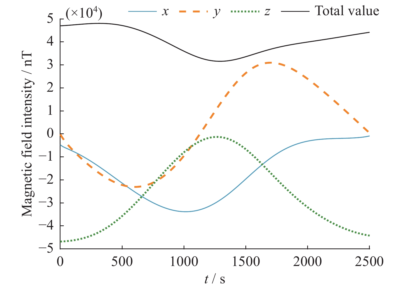
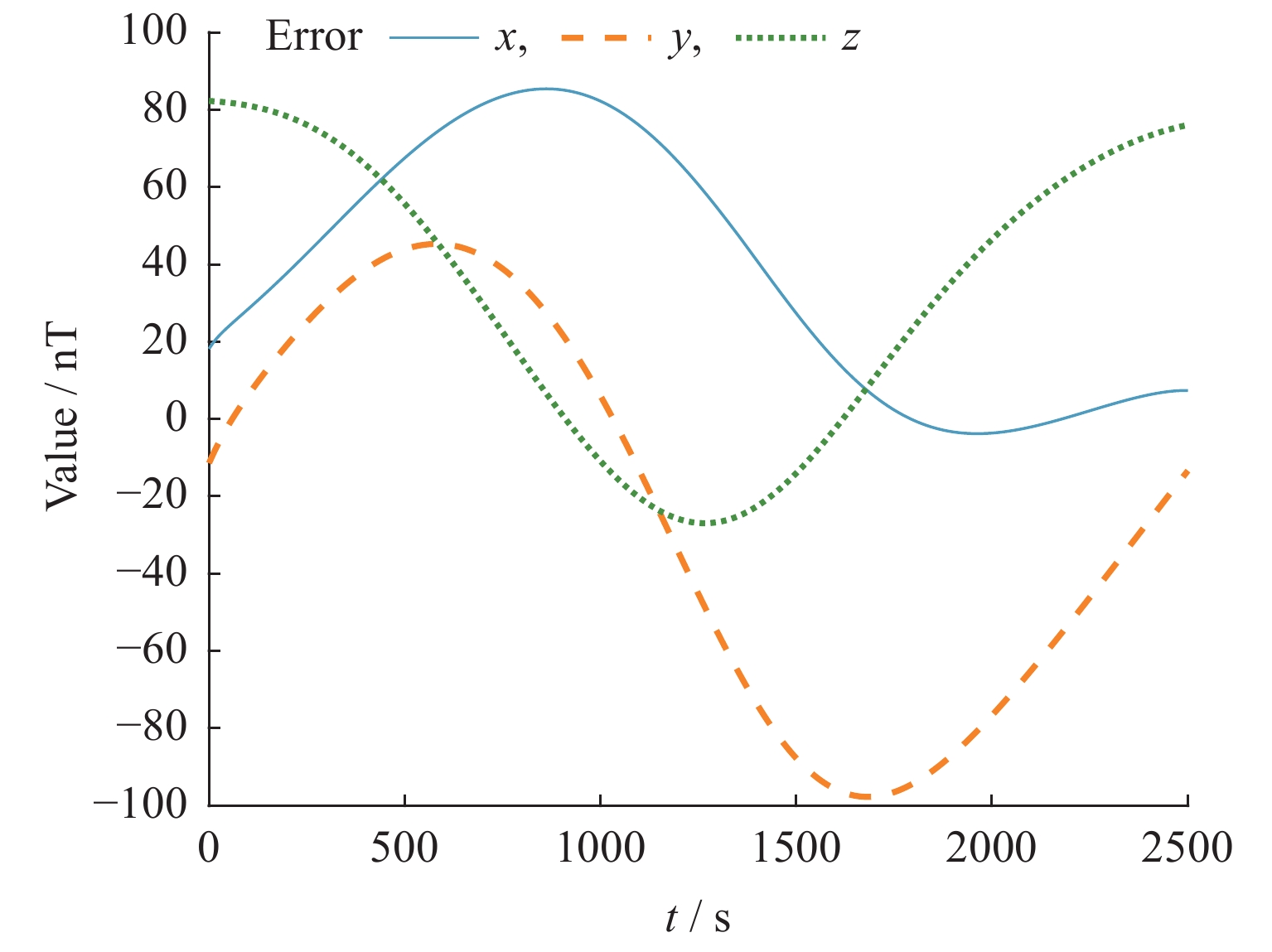
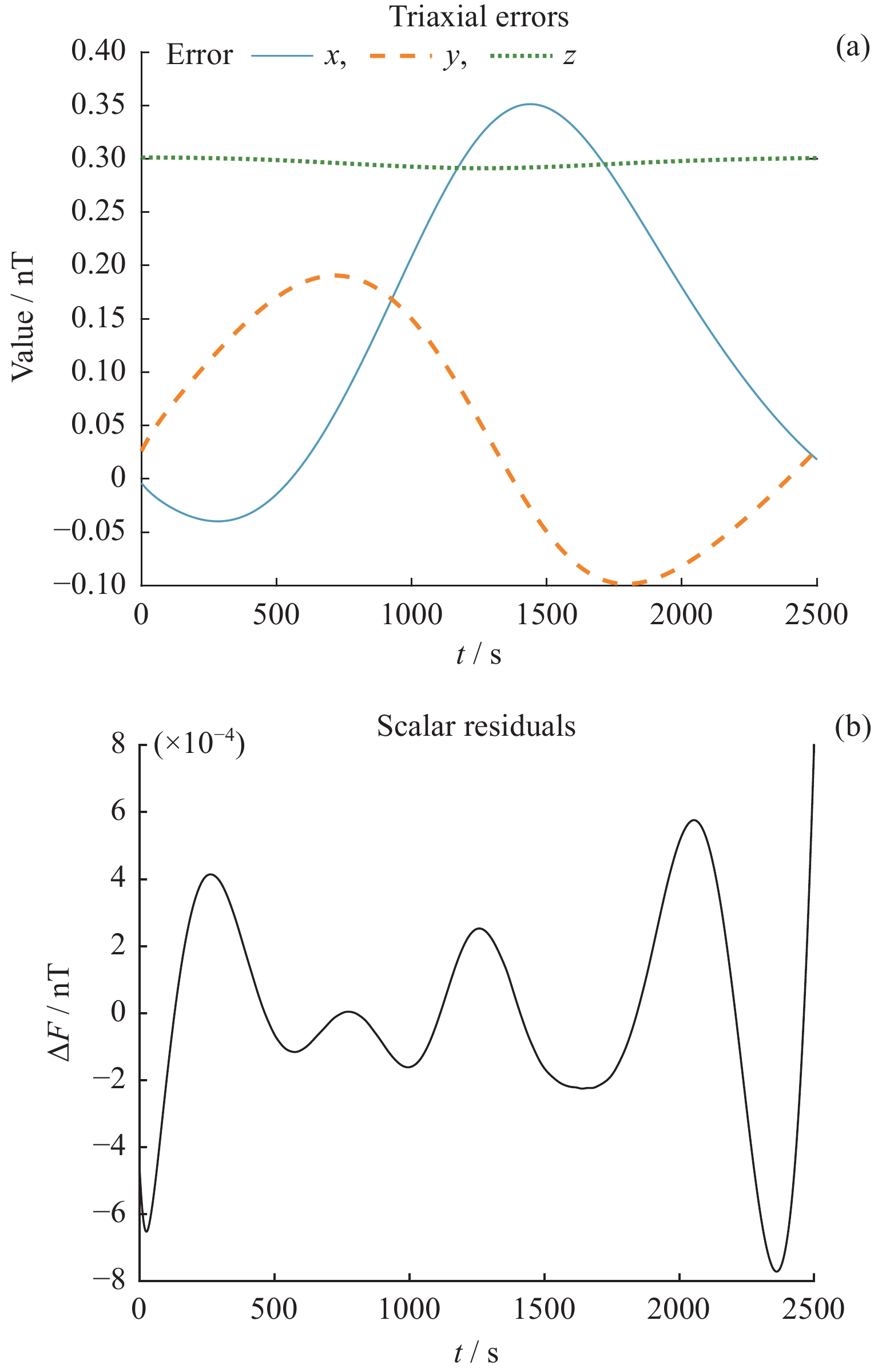
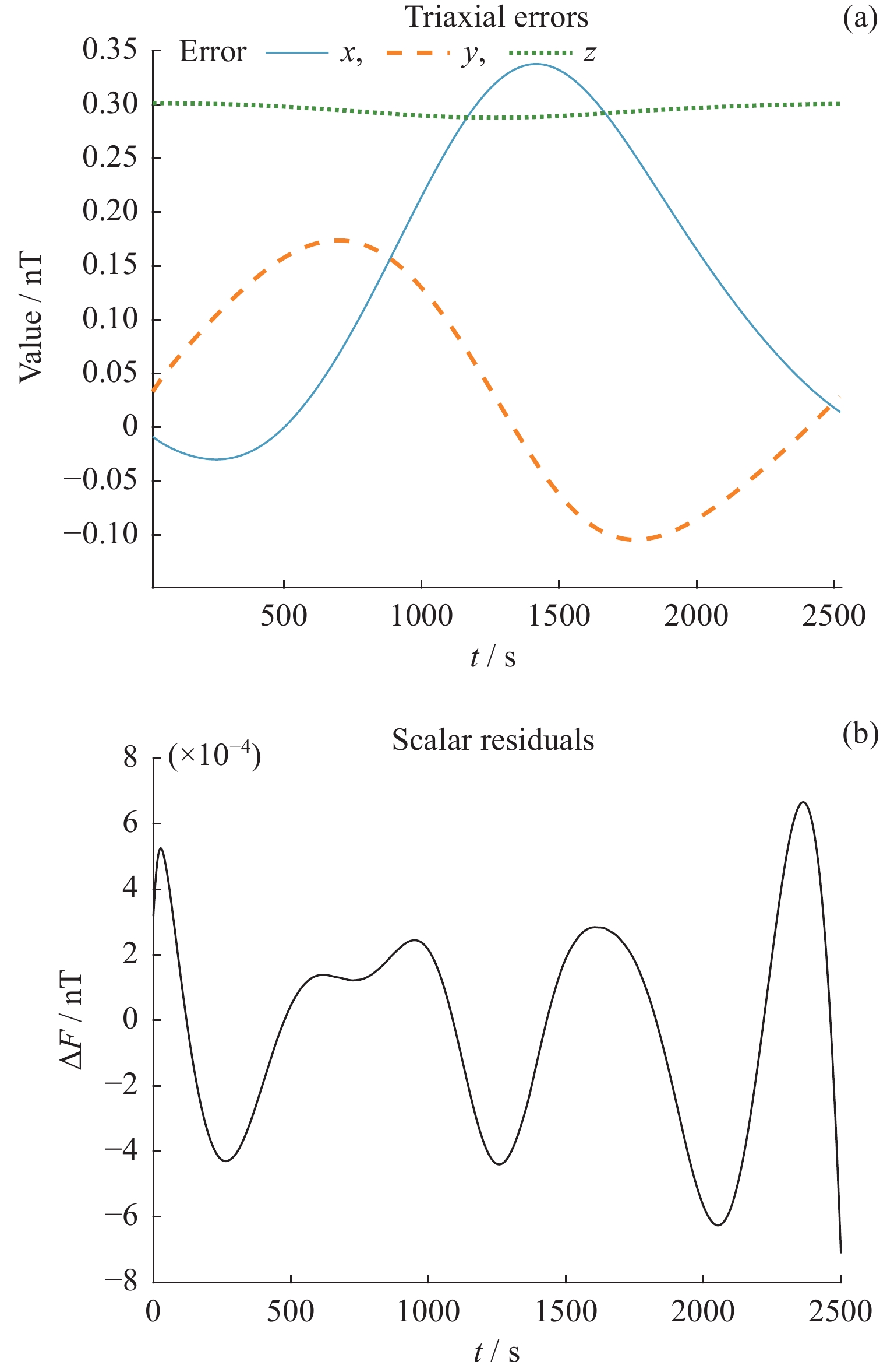
Venus Volcano Imaging and Climate Explorer (VOICE) is an orbiting mission to investigate the Venusian volcanic and thermal evolution history, water and plate tectonics, internal structure and dynamics, climate evolution, possible habitable environment and life information in the clouds. Three state-of-the-art scientific payloads, the Polarimetric Synthetic Aperture Radar (PolSAR), the Microwave Radiometric Sounder (MWRS) and the Ultraviolet-Visible-Near Infrared Multi-Spectral Imager (UVN-MSI), will be flown on a polar-circular orbit of about 350 km. The PolSAR with meter resolution surface imaging capability enables refined exploration of Venusian tectonic and volcanic activity and evolution history. The MWRS, with a combination of a nadir-looking module and a limb-looking module, has the capability to refine the thermal structure and composition of the Venusian atmosphere, including near surface, below-inside and above the clouds, and will reveal the exchange and interaction between the surface and lower atmosphere. The MWRS will also investigate biosignatures, such as PH3 and NH3, in the cloud to further the fundamental scientific questions on the habitable environment and life information in Venus' atmosphere. The UVN-MSI can map the global atmosphere and look through the atmosphere with NIR windows. With combined observations by MWRS and UVN-MSI, our understanding of the atmospheric composition and climate evolution of Venus can be greatly improved. The scientific objective of the VOICE mission is to advance the understanding of the geological and thermal history and evolution of Venus, the mechanisms of the global circulation of Venusian atmosphere, past and current habitable environments, and the possible existence of life in the clouds of Venus. Through the combination of the state of art of payloads and technologies, the mission goals are to search for evidence of water and plate tectonic activities, reveal the type of volcanic activity and thermal evolution history of Venus; establish the composition and thermal structure of middle and lower atmosphere of Venus, and break through the understanding of Venusian atmospheric and climatic evolution; reveal the mechanism of runaway greenhouse effect, and explore whether Venus has a habitable environment and whether life (once) existed.
Space Physics
Autoregressive Prediction Method of E10.7 Index
LEI Lei, ZHONG Qiuzhen, WANG Jingjing, SHI Liqin, MIAO Juan
2022, 42(6): 1060-1067. doi: 10.11728/cjss2022.06.211026107
Abstract:
In response to the demand for the new solar ultraviolet radiation index E10.7 in the operation of upper atmospheric density prediction and orbit prediction, this paper carries out the research on E10.7 index inversion and medium-term prediction based on the integrated solar irradiance from 0.1 to 105 nm provided by TIMED-SEE instrument. The E10.7 index is the radiation flux in the solar spectrum at wavelengths from 0.1 to 105 nm in the same unit as the F10.7 index (sfu, 1 sfu = 10–22 W·m–2·Hz–1). The integrated solar irradiance from 0.1 to 105 nm provided by the TIMED-SEE instrument has the advantages of high time resolution, short delay time, and easy availability. The quasi-real-time E10.7 can be retrieved by least square fitting, and the root mean square error is 5.445 sfu. The average relative error of the next 27 days prediction is 7.83% using the autoregressive model. Using the same method, the 27 days prediction test of the 81-day central moving average of E10.7 is also carried out. The average relative error of the next 27-day predictions of the 81-day central moving average of E10.7 is 3.63%.
Test Particle Simulation of Solar Wind Transport into the Magnetosphere during Northward IMF
ZHAO Mingxian
2022, 42(6): 1068-1078. doi: 10.11728/cjss2022.06.210721078
Abstract:
Using test particle method, with the background fields obtained from a global Magnetohydrodynamics (MHD) simulation driven by the ACE satellite observation data, the transport process of solar wind particles into the Earth’s magnetosphere was simulated during a long-term northward Interplanetary Magnetic Field (IMF) event on 22-24 October 2003. The particle density distribution in the magnetosphere and the time evolution characteristics of the particles were analyzed and discussed. During the northward IMF, the particle density in the dawn-side ring current region is higher than that on the dusk side, and the radial range on the dawn side is wider. The magnetosheath particles on the tail side can transport into magnetosphere through the low-latitude boundary layer, but they are difficult to enter into magnetosphere through the north and south magnetopause. The solar wind particles transported into the nightside magnetosphere gather to form a Cold Dense Plasma Sheet (CDPS). The spatial scale and particle density of the CDPS obtained from the simulation are consistent with observations. During the long-term northward IMF period, the total number of particles in the magnetotail showed a trend of increasing over time. At the same time, there exists a weak quasi-periodic variation with a period of about 20 min and a strong quasi-periodic variation with a period of about 5~6 h.
Parametric Study on Interaction between Superluminous L-O Mode Waves and Radiation Belt Electrons
LI Wentao, ZHANG Sai, HE Jiabei, DENG Zhoukun, YANG Qiwu, SHANG Xiongjun, ZHOU Qinghua
2022, 42(6): 1079-1088. doi: 10.11728/cjss2022.05.210421054
Abstract:
The parametric study focuses on the interaction between the superluminous Left-hand Ordinary (L-O) mode waves and radiation belt electrons. Bounce-averaged diffusion rates in pitch angle, momentum and cross are calculated by varying the peak wave frequency, the wave normal angle distribution, and the wave latitudinal distribution. Calculation results show that the momentum diffusion coefficients are generally greater by about 100 times than the pitch angle diffusion coefficients, which suggests that L-O mode waves have a potential for producing acceleration of electrons. With the varying normal angle range, the change of diffusion coefficients is not obvious, and the result indicates that diffusion coefficients of the interaction between L-O mode and electrons have little dependence on the normal angle range. In addition, diffusion coefficients are largely determined by the wave latitudinal distributions, which is consistent with the case of R-X mode waves. These results indicate that L-O mode can obviously affect the dynamic of radiation belt electrons under appropriate conditions.
Prediction of Global Ionospheric Map Using the Theory of Maximum Posterior Estimation
LIU Ang, WANG Ningbo, LI Zishen, ZHANG Yan, LI Ang
2022, 42(6): 1089-1099. doi: 10.11728/cjss2022.06.210812085
Abstract:
A method based on maximum posterior estimation is proposed for the prediction of global ionosphere. Using the rapid ionospheric products from the Chinese Academy of Sciences (CAS), the 1-, 2- and 5-day predicted Global Ionospheric Maps (GIM) are routinely generated with the proposed algorithm. The qualities of CAS predicted GIMs as well as those from the Center for Orbit Determination of Europe (CODE), European Space Agency (ESA) and the Polytechnic University of Catalonia (UPC), are evaluated during 2008-2017 using Total Electron Content (TEC) references derived from the final GIMs of the International GNSS Service (IGS), Jason altimetry and global GNSS reference stations. The consistency between CAS predicted GIMs and IGS final GIMs is 2.4~3.1 TECU during the test period. Compared to Jason derived TEC observables, the precision of CAS predicted GIMs is on the level of 5.1~6.6 TECU over global oceanic regions. Compared to the TECs derived by global reference stations, the ionospheric delay correction accuracy of CAS predicted GIMs is better than 80%. Overall, the quality of CAS predicted GIM performs at the same level with that from CODE, which is significantly better than ESA and UPC predicted ones.
An Algorithm for Retrieving Ionospheric Electron Density from Far Ultraviolet Remote Sensing Based on Maximum Likelihood Estimation
FENG Taojun, YU Qian, ZHANG Kai
2022, 42(6): 1100-1110. doi: 10.11728/cjss2022.06.211115118
Abstract:
The OI 135.6 nm nighttime emission is dominantly produced by radiative recombination of O+ ions and electrons. Many previous space-based Far Ultraviolet (FUV) remote sensing experiments have demonstrated that OI 135.6 nm nighttime intensity can be used to infer the ionospheric F region electron density. This paper firstly presents a forward model specifying the nonlinear relationship between electron density and 135.6 nm nightglow intensity. Then, we develop an algorithm to infer the altitude profile of electron density from the nighttime 135.6 nm limb intensity measurements using Discrete Inverse Theory (DIT). The algorithm applies maximum likelihood method to iteratively seek the most probable values of the ionospheric parameters. The viability of this algorithm is verified through performing the simulation of the synthetic 135.6 nm limb observation data generated from forward model using the TIMED/GUVI limb scan configuration. Finally, we invert the realistic GUVI limb observation measurements and obtain the retrieved Electron Density Profile (EDP). The comparison between retrieved ionospheric parameters and GUVI products suggests that the forward model tends to overestimate the NmF2 and underestimate the hmF2. The systematic error is within 10% for NmF2 and 5% for hmF2 for different level of solar activity. Determining ionosphere electron density with high precision could help improve the ionospheric model and forecast the space weather.
Event Analysis of the Influence of Strong Tropospheric Convection in Summer on Low-latitude Ionospheric Irregularities in East Asia
SHANG Sheping, SHI Jiankui, CHENG Zhengwei, WANG Guojun, WANG Zheng, WANG Xiao
2022, 42(6): 1111-1121. doi: 10.11728/cjss2022.06.211228135
Abstract:
Using various ground-based and space-based observation methods from the Hainan station and Southeast Asia, the spatiotemporal changes and physical processes of the irregularity events in the low-latitude F region of East Asia observed on the night of July 28, 2014 were analyzed. The main results are as follows. The Hainan station observed a rare occurrence of long-lasting ionospheric irregularities in the F region, and the ionospheric irregularities observed by different means have obvious morphological differences. There are obvious differences in the activities of ionospheric irregularities observed by different stations. The TEC fluctuation activities near the north-south anomalous peaks in the longitude area of Hainan increased significantly before midnight and weakened significantly after midnight. After midnight, the trajectory of the C/NOFS satellite gradually approached magnetic equator and was at a lower altitude. The occurrence of weak plasma disturbances/bubbles was almost always observed, which is obviously related to the activities of weak ionospheric irregularities observed on the ground in this region. The SWARM satellites still observed the strong two peaks of equatorial anomaly near dawn in the longitude region near Hainan station, and there were still the plasma density depletion/bubble structures near the anomalous peak area on the west side. The seed disturbance (gravity waves) excited by the MCC near the magnetic equator on the west side of the Hainan station (Indochina Peninsula) may play an important role in the generation of plasma bubbles and their quasi periodic structures in the low latitude region of East Asia.
Characteristics of Ionospheric Multiparameter Changes in Qujing Area
DAI Liandong, DING Zonghua, YANG Song, MIAO Jiansu, XU Zhengwen, WU Jian
2022, 42(6): 1122-1128. doi: 10.11728/cjss2022.06.211115117
Abstract:
The Qujing ionospheric vertical sounders 11 years data in network of radio environment observatories are processed. The correlations between ionosphere parameters and solar activity month local time are analyzed including fmin, f0Es, h'Es, f0E, f0F1, f0F2, h'F, MUF(3000)F2. Several interesting results are achieved. Firstly, the relationships between fmin, f0Es, h'Es and solar activity are not obvious, but f0E, f0F1, f0F2, h'F, MUF(3000)F2 have good correlation with solar activity. Secondly, the value of f0F2 parameter often enlarged on sunset, and both are independent. The f0F2, h'F, MUF(3000)F2 parameters variation trend of Lhasa and Urumqi are compared, it is found that the variation trend of local time and month are similar, but extreme values appeared in different positions. This phenomenon may have a relationship with topography and latitude and longitude. Thirdly, the daytime value of h'F is smaller than night, and rise abruptly at sunrise and sunset, and the winter h'F value is smaller than other seasons. Fourthly, the change trend of MUF(3000)F2 is similar with f0F2, the daytime value is higher than night, the equinox value is higher than summer and winter, and the MUF(3000)F2 value in high solar activity year is high till 03:00-04:00 LT on the morning.
Simulation of Solar Ultraviolet Radiation Environment in Near Space and Analysis of Topographic Difference
ZHANG Xuanyi
2022, 42(6): 1129-1136. doi: 10.11728/cjss2022.06.211208128
Abstract:
Solar ultraviolet radiation is one of the main sources of energy input into near space. The study of its radiation characteristics in the mid-atmosphere is an important basis for the study of atmospheric composition and density changes, photochemical reactions and dynamic processes in near space. This paper is based on the special project of HH, using MODTRAN5 radiation transfer model and satellite ozone data, the similarities and differences of the vertical distribution and seasonal evolution of ultraviolet radiation (200~400 nm) in the near space (20~50 km) over 11 major terrain areas in China were compared. The function between ozone content and radiation transmittance is calculated, and the influence of solar zenithal Angle and sun-earth distance on radiation intensity is analyzed. The results show that the vertical distribution profiles of radiative flux in each terrain area are consistent with the vertical distribution profiles of the annual difference, and the radiation characteristics and seasonal evolution in geographically adjacent regions are similar, but there are great differences between different bands of solar UV. The results provide data support for near-space exploration experiments, and provide reference for atmospheric inversion and other related fields.
Characteristics of Fair-weather Atmospheric Electric Field in Tibetan Ngari Prefecture
WANG Shihan, LI Lei, CHEN Tao, SONG Jiajun, TI Shuo, LI Wen, LUO Jing, SU Jianfeng, CAI Chunlin, LI Renkang, WU Han
2022, 42(6): 1137-1144. doi: 10.11728/cjss2022.06.211115116
Abstract:
Fair-weather atmospheric electric field is the benchmark field of atmospheric electric field variation in a region, and is the basis for studying the characteristics of the atmospheric electric field in the region. However, it is significantly different for different geological conditions, different geographical environments and topography. The research team of Meridian Project of National Space Science Center of Chinese Academy of Sciences has installed a mill-type atmospheric electric field meter at Tibetan Ngari Prefecture seismic station (80.12°E, 32.51°N), and this paper is mainly based on the atmospheric electric field observation data of this meter from 10 October 2021 to 10 November 2021, through the data modeling and analysis of the atmospheric electric field meter, combined with the analysis of meteorological conditions. The average Carnegie curves were obtained for 23 days of clear sky conditions in Tibetan Ngari Prefecture region. In order to obtain the standard Carnegie curve, the curve was smoothed to remove the fluctuation of the instrument noise, and then the characteristics of the fair-weather atmospheric electric field in Tibetan Ngari Prefecture region were summarized and compared with the fair-weather Carnegie curve of Beijing Changping District Ⅹ Ⅲ Ling Observatory (116.23°E, 40.25°N), and its characteristics and reasons were discussed. It has important reference value and scientific significance to study the characteristics of the electric field in the plateau region.
Influence Factors of GIC in Two Substations of Geomagnetic Storm on 11 October 2021
GAO He, ZHANG Qianran, LIU Lianguang, WANG Peng, JIANG Nan, ZHOU Lichao
2022, 42(6): 1145-1151. doi: 10.11728/cjss2022.06.211130127
Abstract:
In recent years, China has successively monitored the Geomagnetically Induced Current (GIC) data generated by geomagnetic storms against the power grid, railway track circuit as well as the oil and gas pipeline system, However, the measured GIC data are relatively few at present. According to the Geomagnetic Disturbance (GMD) data of geomagnetic storm with Kp index of 6 generated by CME on 9 October 2021, the parameters of 500 kV Alatan substation (48.7°N, 116.8°E), Shanghe substation (33.4°N, 119.2°E) and transmission system, the GIC data monitored in two substations during the geomagnetic storm on 11 October 2021, and the influence of transmission system parameters on the GIC value are analyzed. Results show that the GIC value produced by geomagnetic storm in 500 kV Shanghe substation is relatively larger than that in Alatan substation. The analysis results show that the conductor resistance of transmission line is the main factor affecting the GIC of substation in this magnetic storm event.
Microgravity and Space Life Science
Ground Experiment Investigation of PIV Unit for Combustion Science Experimental System of China Space Station
HE Lifang, ZHENG Huilong, WANG Xikun, YANG Xiaofang, ZHANG Xiaowu
2022, 42(6): 1152-1160. doi: 10.11728/cjss2022.06.211123121
Abstract:
The Combustion Science Experimental System of China Space Station is a comprehensive scientific platform for microgravity combustion experiment research, which is feasible for velocity measurement. In order to test the feasibility function of Particle Image Velocimetry (PIV), an experimental platform for laminar circular orifice jet, which has the same spatial layout of the laser and camera as that in-orbit operation, was built for reacting flow field and non-reacting flow field experiment. Al2O3, TiO2 and ZrO2 were selected as tracer particles. The experimental results indicate that the combustion science experimental system of PIV unit is feasible for low-speed combustion field measurement. Under the same conditions, the obtained velocities by using Al2O3 particles are closer to analytical values with velocity amplitude ratio nearest to 1, which suggests that Al2O3 particles are more suitable for low-speed field. The present study can provide the selection basis for particle species in ground-space comparison experiments.
Effects of Different Particle Sizes on the Bulk Density, Porosity Character, Water Suction of Substrates
TANG Yongkang, SHEN Yunze, AI Weidang, WU Zhiqiang, MAO Ruixin, WU Hao, HU Wei, FENG Hongqi
2022, 42(6): 1161-1170. doi: 10.11728/cjss2022.06.220125009
Abstract:
To study the effects of different particle sizes on the bulk density, porosity character, water suction of substrates and select suitable substrate combinations for higher plants cultivation in space. Four substrates including profile particle (P), black ceramic particle (B), white ceramic particle (W), and vermiculite (V) were selected, and 10 kinds of particle size combinations (volume percent) are set, in which basic physicochemical character, bulk density, porosity character and water suction were tested. The bulk density of P and B substrates was 0.70 g·cm–3 and there were many minerals in P substrate. The bulk density, Total Porosity (TP) and Water Holding Porosity (WHP) of different substrate combinations increased significantly (p < 0.05) with the increase of proportion of < 1 mm particle size of substrates, but not for Air Porosity (AP). In the 10 kinds of substrate combinations, there were the highest total porosity for P7 (40-60-0) , B8 (10-70-20) and W4 (10-60-30), the highest water air ratio for P8 (10-70-20), B1 (20-50-30) and W8 (10-70-20), the highest adsorption water volume for P3 (50-50-0), B3 (50-50-0) and W3 (50-50-0). The order of average total porosities of 4 kinds of substrates was V> P> B> W. There are moderate bulk density, good porosity character and higher water suction for the P3(50-50-0) and B7 (40-60-0) substrates, which are suitable for plants cultivation in space.
Space Exploration Technology
Development of High-energy Particle Detectors for Space Exploration
YANG Zhe, SHEN Guohong, JING Tao
2022, 42(6): 1171-1184. doi: 10.11728/cjss2022.05.210611068
Abstract:
Space environment exploration is a hot topic globally. The scope of space exploration ranges from near-Earth space to the moon, other planets in the solar system, and even the heliosphere and interplanetary space. It is used for various crucial applications, including aerospace technology development, space weather research, understanding the origin and evolution of the universe, searching for extraterrestrial life, and finding human livable places. Although China’s space environment exploration started late, its progress has been rapid. China is gradually narrowing the gap with advanced countries and may eventually lead the world in space research. This article briefly reviews the development history of China’s space environmental detectors.
Space Event and Outlier Detection Based on Expectation Maximization Algorithm
LIU Jinghong, WU Chenyun, XU Jin, DU Jianli, LEI Xiangxu
2022, 42(6): 1185-1192. doi: 10.11728/cjss2022.06.211124123
Abstract:
The United States provide Element Sets (ELSET) database in Two-Line Element (TLE) format for public use, which plays an important role in the inversion of atmospheric density in the thermosphere, ballistic coefficient estimation, early-warning and so on. Due to large uncertainties existing in the TLE generation process, space environment changes and space events, ELSET database contains a large number of abnormal TLE data to be filtered, such as corrected TLE, orbital element outlier and Bstar outlier. The existing methods to filter out the outliers lack general applicability and are very complicated, which are only applicable to a few space targets in certain orbit regions. To overcome the shortcomings of the existing methods, a filtering method is proposed based on Expectation Maximization (EM) algorithm employing a sliding window and polynomial fitting method, which can detect outliers for different orbital elements and space events. The research shows that the algorithm can effectively single out the outliers in TLE sequences and is suitable for all orbital debris.
Simulation of Vector Magnetic Field In-orbit Calibration Algorithm for Geomagnetic Survey Satellite
DU Wen, HUANG He, ZHOU Jun
2022, 42(6): 1193-1203. doi: 10.11728/cjss2022.06.211224131
Abstract:
The precision of geomagnetic survey satellites represented by SWARM is better than 0.5 nT for detection of the Earth’s magnetic field after calibration. The satellites obtain the geomagnetic information of inertial space attitude in measurement direction through the vector fluxgate magnetometer, scalar magnetometer and high-precision star tracker installed on the extension boom. The high-precision scalar magnetometer is mainly used to calibrate the fluxgate vector magnetometer. Calibration methods of in-orbit measurement error of vector magnetometer are proposed for geomagnetic survey satellite. Considering the non-orthogonal angles, scale factors and deviations of vector magnetometer, the linear output model of magnetic field vector is established. The linear correction algorithm based on small approximation and nonlinear correction algorithm based on parameters identification update are designed respectively combined with the measurement values of scalar magnetometer. The calibration accuracy of algorithms is verified, and the robustness of the algorithms is improved by Tukey weight function. Simulation results show that the correction results are similar, the triaxial errors of magnetic field can be corrected to less than 0.5 nT, and the algorithms still have a good correction effect when there is an outlier in scalar measurements.
Design and Realization of the Ultra-violet Imager Communication and Control System Based on Packet Utilization Standard
LIU Xiaohong, WANG Yongmei, WANG Tianfang
2022, 42(6): 1204-1209. doi: 10.11728/cjss2022.06.211108112
Abstract:
For conventional satellites in China, telemetry and tele-command system has limitations due to the format inconsistency. As the payload becomes more complex, the format of the communication system requires rebuiltion and many constraints in operation will be produced due to the lack of flexibility. For Ultra-violet Imager (UVI) instrument in SMILE mission, a new strategy for the communication system derived from PUS (Packet Utilization Standard) is used for the efficiency of data handling. In this paper, principle of the communication system and the description of PUS standard used are presented. Then each section of the communication system is described in detail. Finally, the integrated test of the completed system is carried out. The test results show that the system is stable and could meet the requirements. This system can be used as a reference for the engineering application of the PUS in other satellites in China.
Design of On-orbit Autonomous Control for Payload Management Software Based on Data Sheet
GE Fei, ZHANG Qiao, ZHANG Yajuan
2022, 42(6): 1210-1221. doi: 10.11728/cjss2022.05.210429057
Abstract:
With the continuous development of space technology, the structure of spacecraft has developed from simple configuration to large complex structure and small miniaturized structure, and the characteristics of the spacecraft task have changed from singularity to diversification and specialization. In order to better adapt to this variety of tasks, an autonomous control scheme for on-orbit work is designed. In this scheme, the requirements of multiple types of software are summarized and analyzed as a whole, and the autonomous control of on-orbit work is divided into modules and functions. It can control the working sequence, monitor and manage the working state of different loads in different working modes, and solve the diversification and customization problems caused by the difference of on-orbit work control requirements of multiple load management software. The configurable design idea is introduced, and the data sheet is established to configure the load workflow, which solves the problem of adaptability to the on-orbit workflow of specific load. This method has been used in many types of satellite load managers to meet the requirements of diversified work flow of load unit. The reuse of software not only greatly improves the time of software design and testing phase, shortens the software development cycle, but also reduces the software development cost, and improve the reliability of the software in the whole development stage.
High Performance Real-time Odd-even Channels Combination Algorithm for Transmission Baseband Data Using Dual-polarized Technology
ZHANG Xinyu, YANG Jiasen, ZHANG Xuefeng, XU Cong, CHEN Zhimin, ZHI Jia, CHEN Tuo
2022, 42(6): 1222-1229. doi: 10.11728/cjss2022.06.211125125
Abstract:
Odd-even frames real-time combination for transmission baseband data which used dual-polarized technology is the prerequisite and basis for timely monitoring of satellite equipment status when the satellite is in transit arc and early access to scientific exploration data by satellite ground application system. A high performance real-time odd-even channels combination algorithm for transmission baseband data which uses dual-polarized technology is proposed to meet the need of scientific satellite real-time high-speed data processing. This method makes full use of the naturally ordered frame counting feature of each virtual channel and applies the circular memory management design of circular queue. Therefore, this method effectively avoids the time-consuming sort and frequent memory moving operations compared to traditional algorithms. The space science satellites’ engineering practice shows that the speed of combination meets ASO-S’s 1 Gbit s–1 and CASEarth’s 1.6 Gbit s–1 real-time processing requirements.
Space System AI
Two-level Game Based Multi-arm On-orbit Servicing Spacecraft Path Planning
GAO Tian, WU Yunhua, ZHANG Xiao, YUE Chengfei
2022, 42(6): 1230-1238. doi: 10.11728/cjss2022.06.yg32
Abstract:
A two-level game strategy is proposed for the on-orbit servicing spacecraft multi-arm path planning and collision avoidance. The first-level game, i.e., end-effector game, is utilized to guarantee the capturing path planning of multi-manipulator while the second-level game, i.e., elbow joint game, is used to avoid self-collision during motion and govern a balanced distribution between multiple arms. The kinematics for the multi-manipulator is established and the game model of multi-manipulator is formulated on the basis of the game theory. Then the basic process of the proposed two-level game is given as well as the algorithm for obtaining the Nash equilibrium to solve the proposed two-level game strategy. Simultaneously, some simulation analyses are carried out under the scenario of multi-arm spacecraft round-up a moving target case to demonstrate the effectiveness and practicality of the proposed method. Simulation results verify the performance of the proposed two-level game in high precision end-effector planning and elbow joint collision avoidance in the capture process. The proposed method provides a new solution for intelligent path planning and control deployed multi-arm on-orbit servicing spacecraft.